📰 Trending Topics
Google News - Trending
Google News - Technology
A decade later, Pokémon Go finally made good on its original promise - The Verge
2026-07-10 19:51
- A decade later, Pokémon Go finally made good on its original promise The Verge
- More Than a Thousand ‘Pokémon Go’ Players Descend on Times Square to Defeat Mewtwo WIRED
- ‘Pokémon Go’ Exec Promises 1,000-Person Times Square Mewtwo Event Is Just the Start of 10th Anniversary: ‘My Personal Goal Is to Create Core Memories’ for All Players Variety
- 10 years later, ‘Pokémon Go’ is as popular as ever Fast Company
- Pokémon Go's big 10th anniversary Times Square stunt was stellar, but fans are still furious Polygon.com
These are my favorite new Messages features in iOS 27 [Video] - 9to5Mac
2026-07-10 15:28
- These are my favorite new Messages features in iOS 27 [Video] 9to5Mac
- 9 new features Apple added to iPhones Popular Science
- iOS 27: 13 Ways the Messages App is Smarter and Less Annoying MacRumors
- watchOS 27’s new Siri finally fixed my dumb timer problem Macworld
- iOS 27: What's New With the Mail App MacRumors
OpenAI is shutting down its Atlas web browser - Mashable
2026-07-10 17:41
- OpenAI is shutting down its Atlas web browser Mashable
- The ChatGPT "Super App" Sort of Super Sucks spyglass.org
- OpenAI is shutting down Atlas, but its AI browser ambitions are still growing TechCrunch
- OpenAI's Browser Isn't Dead, It Just Moved To The ChatGPT App Engadget
- OpenAI to Retire ChatGPT Atlas Browser Less Than a Year After Launch PCMag
iPhone Ultra battery capacity leaks - GSMArena.com news - GSMArena.com
2026-07-10 20:07
- iPhone Ultra battery capacity leaks - GSMArena.com news GSMArena.com
- Foldable iPhone Ultra Battery Capacity Allegedly Registered by Supplier MacRumors
- iPhone Fold battery now rumored to have less capacity than expected AppleInsider
- iPhone Fold To Feature A Dual-Battery Configuration, But If You Want Better Runtime, You’ll Have To Upgrade To The iPhone 18 Pro Max Instead Wccftech
- Foldable iPhone Ultra battery capacity leaks, and it seems Apple is playing it safe PhoneArena
NASA - Breaking News
Early Career Faculty (ECF) 2025 Awards
2026-07-10 19:23
1 min read
Preparations for Next Moonwalk Simulations Underway (and Underwater)
Advanced Diagnostics for High-Enthalpy Test Facilities Simulating Spacecraft Atmospheric Entry
- Damiano Baccarella
University of Tennessee, Knoxville
Application of Resonance Enhanced Multi-Photon Ionization Diagnostics to the Characterization of Arcjet Flows - Ciprian Dumitrache
Colorado State University
Ultrafast Laser Diagnostics for Nonequilibrium Flowfields Characterization in Atmospheric Entry Studies - Dan Fries
University of Kentucky, Lexington
Multiplexed Polarization Spectroscopy for Single-Shot Multi-Species Diagnostics in High-Enthalpy Flows - Yi Mazumdar
Georgia Institute of Technology
Simultaneous Temperature, Species, and Velocity Measurements using Ultrafast Laser Diagnostics for Ground Testing of Spacecraft Atmospheric Entry Systems
Planning for Autonomous Spacecraft Using Machine Learning Methods to Enable Onboard Guidance, Navigation, and Control
- Glen Chou
Georgia Institute of Technology
Robust Real-Time Hierarchical Neural Planning and Control with System-Level Guarantees - Roshan Eapen
Pennsylvania State University
Hamilton-Jacobi aided Planning and Reasoning for Intelligent Spacecraft Maneuvers (HJ-PRISM) - Bin Hu
University of Houston
Safety-Enabled and Efficient Onboard Planning for Autonomous Spacecraft via Physics-Informed Reinforcement Learning
NASA Volunteers Help Zooniverse Reach 1 Billion Classifications
2026-07-10 19:00

The Zooniverse, a NASA grantee that runs the world’s largest platform for online people-powered research, has reached an extraordinary milestone: 1 billion classifications contributed by volunteers around the world. This milestone is a celebration of everyone who has marked a dip in a light curve, confirmed the presence of a moving object in a short video, or identified species in a camera trap image. Each of these small contributions collectively advances our understanding of the universe.
A total of 31 NASA-sponsored citizen science projects have been hosted on Zooniverse, accounting for 120 million classifications by 324 thousand volunteers since 2020. Through projects like Planet Hunters TESS, Daily Minor Planet, Backyard Worlds: Planet 9, Space Umbrella, and Snapshot Wisconsin, volunteers help discover exoplanets, identify near-Earth objects and asteroids, search for brown dwarfs and planetary systems, analyze effects of the solar wind, and inform wildlife management decisions. These projects have led to 96 scientific publications, and 56 of these articles feature NASA citizen scientists as co-authors to recognize the significance of their research contributions. These efforts demonstrate how public participation can accelerate discovery by combining human curiosity and pattern recognition with data from NASA missions and observatories. Collaboration between volunteers, scientists, and computing technology will be even more important in the future as we tackle enormous and complex datasets, like those from NASA’s upcoming Nancy Grace Roman Space Telescope.
“One billion classifications represent far more than a number; it’s one billion moments of curiosity transformed into meaningful contributions to research,” said Laura Trouille, principal investigator of Zooniverse and vice president of Science Engagement at the Adler Planetarium. “Every classification on Zooniverse brings us one step closer to new discoveries and a deeper understanding of our universe, our world, and ourselves.”
Zooniverse is the world’s largest platform for people-powered research. Co-founded by the Adler Planetarium and the University of Oxford, with the University of Minnesota serving as a key institutional partner, Zooniverse enables anyone, anywhere to contribute directly to real scientific research. Through its six-year collaboration with NASA, Zooniverse provides science-enabling infrastructure to NASA researchers through tools and a community of more than 3 million registered volunteers.
NASA Photographer Captures Images from F-18 Over Washington
2026-07-10 16:36
2 min read
Preparations for Next Moonwalk Simulations Underway (and Underwater)

NASA flight photographers capture history from a perspective few ever experience, getting a rare bird’s-eye view of the agency’s missions in action. Their photos document key NASA research and give the public a front-row seat to the work happening behind the scenes.
Jim Ross, a photographer at NASA’s Armstrong Flight Research Center in Edwards, California, flew over Washington during the Fourth of July celebration to document a NASA flyover commemorating America’s 250th birthday. He’s captured some of the agency’s most exhilarating milestones, like early SR-71 flights, the delivery flight of Space Shuttle Endeavour to Los Angeles, and first flights of NASA’s X-59 quiet supersonic research aircraft.
“I grew up in Bozeman, Montana, when it was still considered a small town, so if someone told that little kid that he would be flying in a F-18 over the National Mall, he would have never believed it,” Ross said. “I love documenting history, and having the opportunity to capture flights and launches has kept me doing it for almost 37 years.”
Ross began his aviation photography career in 1989 when he joined the staff at NASA Armstrong (then Dryden). He became the photo lead in 1997, a title he retains.
Check out his images from the flyover here: https://www.nasa.gov/gallery/freedom-250/


Share
Related Terms
Explore More


Waxing Gibbous Moon
2026-07-10 15:08
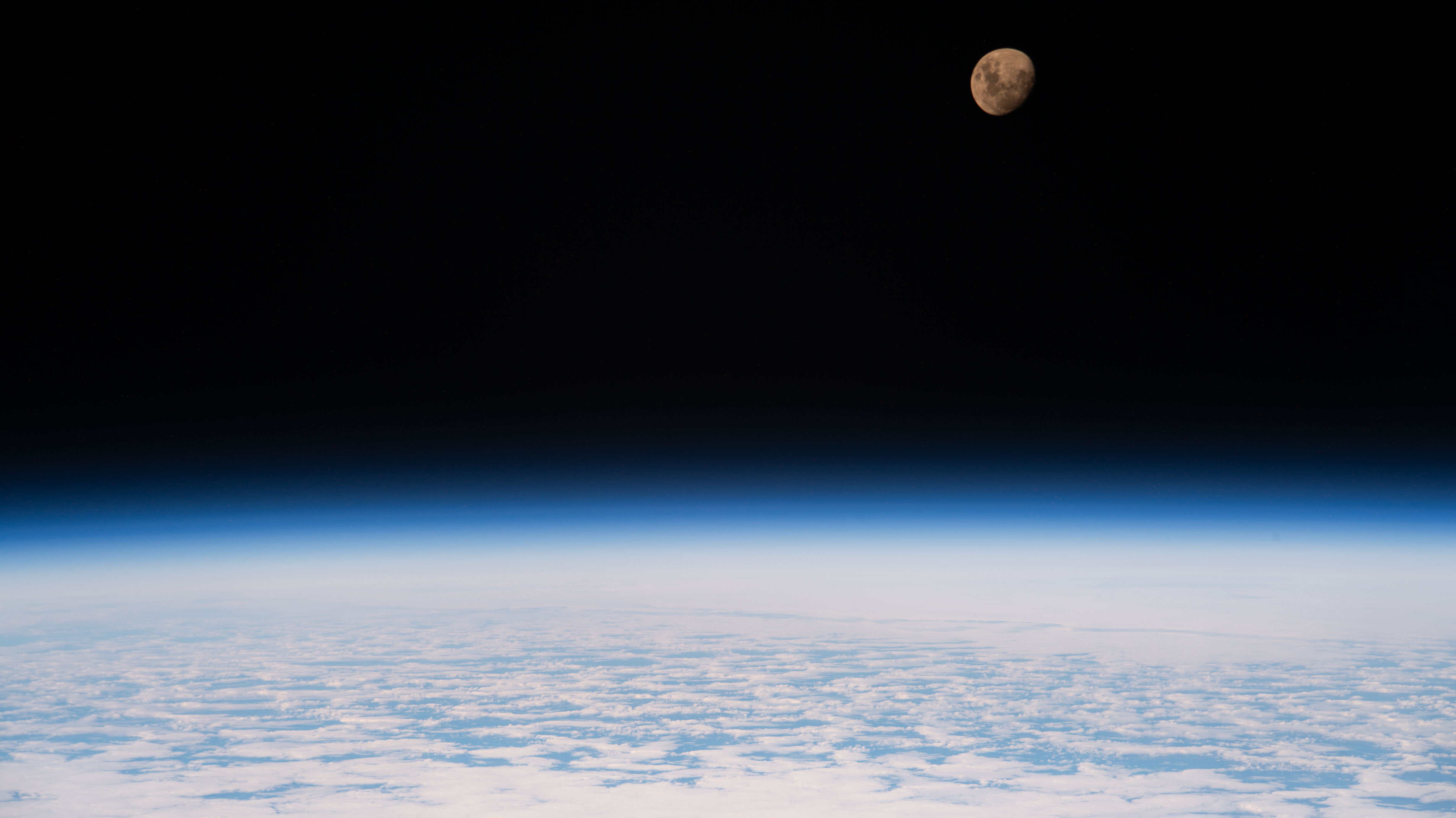
The waxing gibbous moon is nestled in the darkness of space in this June 26, 2026, image from the International Space Station. The space station was 264 miles above the Indian Ocean southeast of Madagascar at the time.
The waxing gibbous phase comes before the full moon phase. During this time, the Moon appears brighter in the night sky to viewers on Earth.
Image credit: NASA
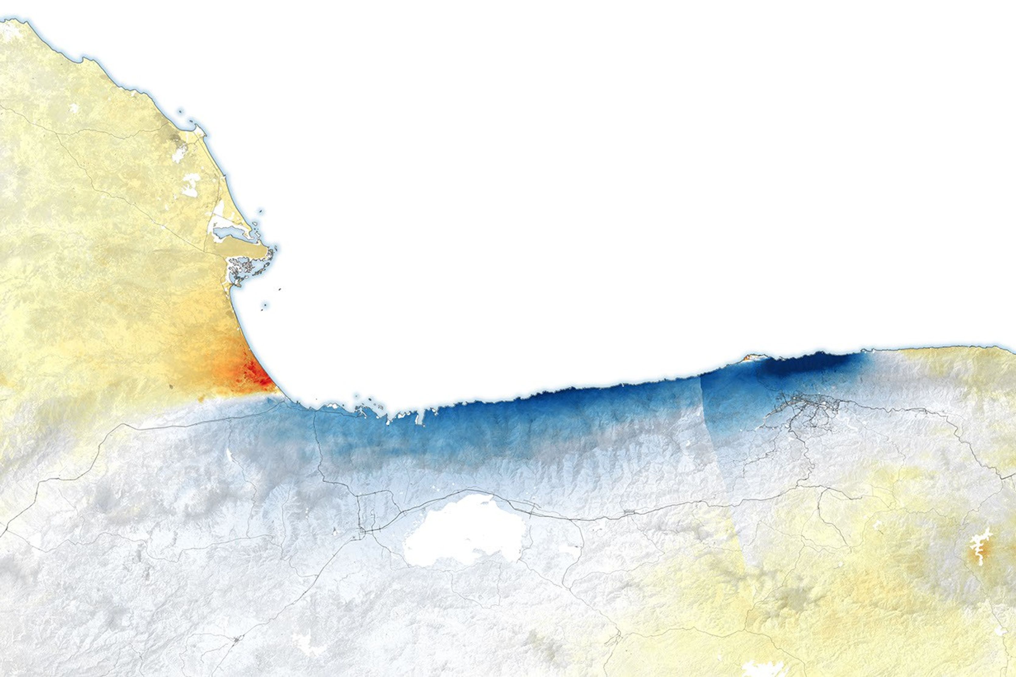
Where Venezuela’s Earthquakes Shifted the Ground
2026-07-10 04:00
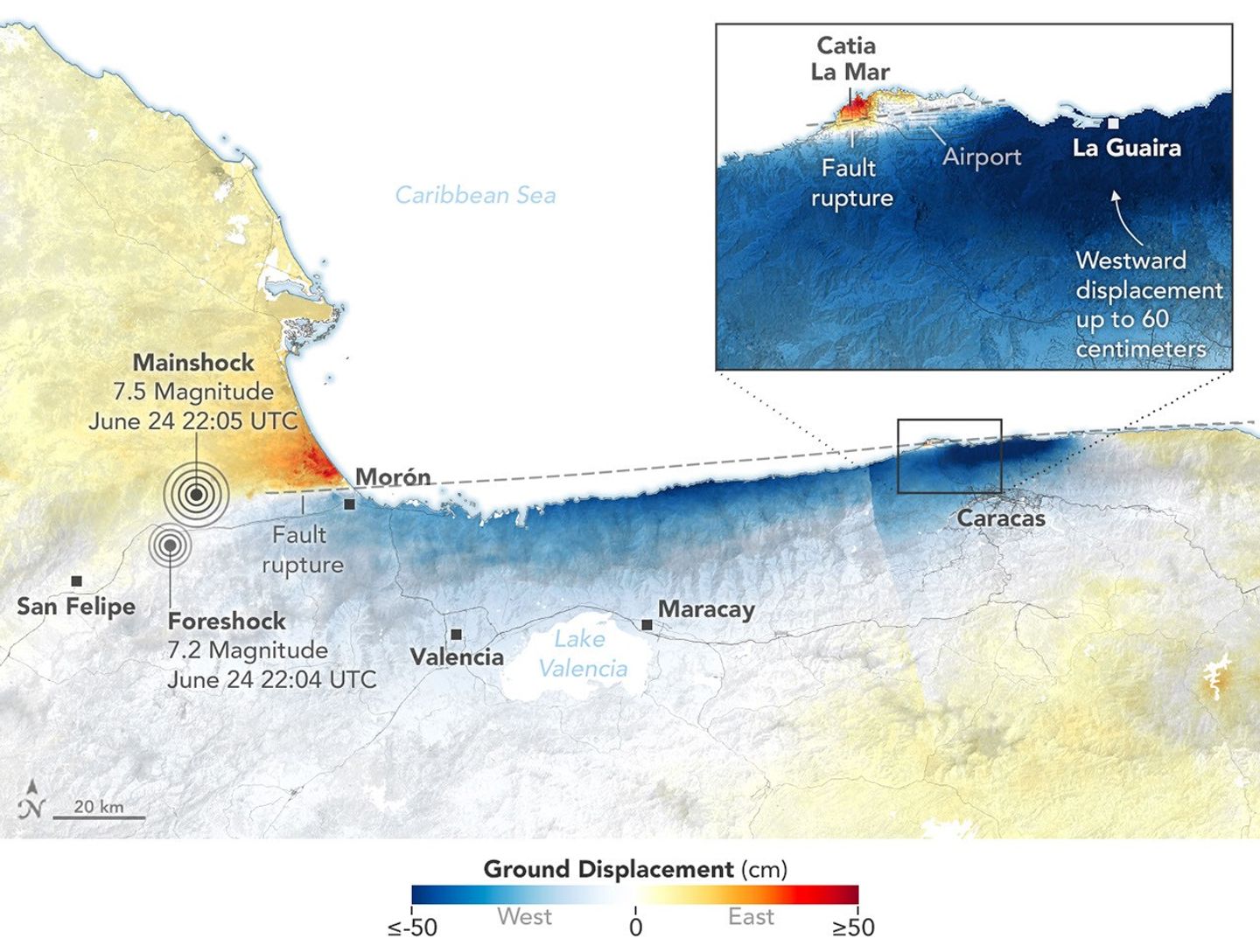
On June 24, 2026, a magnitude 7.2 earthquake struck northern Venezuela, followed under a minute later by a magnitude 7.5 mainshock. Together, the quakes left immense damage and loss of life across the region. In the days that followed, satellite-based maps of ground displacement revealed how the land surface moved, providing insight into the forces behind the severe destruction in locations such as La Guaira and other coastal cities in La Guaira state.
This map was produced using data from the NISAR (NASA-ISRO Synthetic Aperture Radar) satellite and processed by the NISAR science team at NASA’s Jet Propulsion Laboratory (JPL). Scientists used a technique called InSAR, which compares data from repeat passes to detect subtle changes in the distance between the satellite and the ground. Images acquired on June 25 and June 30, after the quakes, were compared with images from June 13 and June 18, before the quakes.
NISAR views Earth at an angle, about 40 degrees from straight down, allowing it to capture a mix of horizontal and vertical displacement. In this map, red areas show where the ground moved east and up; blue areas moved west and down. Because the earthquake occurred on a strike-slip fault, however, most of the displacement shown in this map was horizontal (east and west).
White areas indicate little to no land displacement, including a thin strip near the middle-left of the scene, close to Morón, marking roughly where the fault ruptured at depth. The fault is part of a network of fractures that lies along the boundary between the Caribbean plate to the north and the South American plate to the south. Scientists say faults along this plate boundary, including the San Sebastián fault system where these quakes likely occurred (and possibly part of the Boconó system), have long been accumulating strain.
The fault rupture propagated offshore, toward the east, and then back onshore near the international airport north of Caracas, marked by the narrow white band visible between westward and eastward displacement. Just south of this fault section, the deep blue color indicates that the westward surface displacement along this part of the fault was far greater than elsewhere, reaching as much as 60 centimeters (24 inches).
“These are reasons why the damage in Caracas and La Guaira was so extreme,” said Eric Fielding, a geophysicist at JPL who provided the maps. “InSAR tells us a lot about what happened during this earthquake.”
Using the NISAR data, the U.S. Geological Survey refined its fault-slip model, or “finite fault model,” to better constrain how the fault slipped at depth, including along the rupture’s eastern section. “That is extremely helpful for the people who need to understand why damage was so severe in that area,” Fielding said.
The displacement maps for this event were provided through NISAR’s Urgent Response (UR) system, a fast-track process that can deliver data within 12 to 24 hours to support disaster response. The rapid processing relies on predicted orbit information, so UR maps are preliminary until they are later reprocessed with precise orbit information, typically within a day or two. This marks the first time the NISAR UR system has been used to map surface displacement from a large earthquake.
NASA Earth Observatory map by Lauren Dauphin, using data provided Eric Fielding and processed by the NISAR science team at NASA’s Jet Propulsion Laboratory (JPL). Story by Kathryn Hansen.
References & Resources
- NASA (2025, July 23) Interferometry. Accessed July 9, 2026.
- NASA Earth Observatory, (2025, September 15) Mapping Kamchatka Earthquake Displacement. Accessed July 9, 2026.
- NASA Earth Observatory, (2025, April 15) Satellite Data Show Motion of Burma Earthquakes. Accessed July 9, 2026.
- NASA’s Disasters Mapping Portal (2026, July 9) Venezuela Earthquake June 2026. Accessed July 9, 2026.
- U.S. Geological Survey (2026, June 24) M 7.2 – 21 km ENE of San Felipe, Venezuela. Accessed July 9, 2026.
- U.S. Geological Survey (2026, June 24) M 7.5 – 20 km ESE of Yumare, Venezuela. Accessed July 9, 2026.
You may also be interested in:
Stay up-to-date with the latest content from NASA as we explore the universe and discover more about our home planet.

An astronaut’s photo, taken en route to the Moon, reveals our planet and its place in space in a novel…

Antarctic Iceberg A-23A’s journey ends in fragmentation in the South Atlantic Ocean, after a 40-year lifespan documented by satellites.

Over the years, astronauts aboard the International Space Station have photographed several of the cities hosting the 2026 FIFA World…


TechCrunch - Latest
US cybersecurity agency CISA had to build its incident playbook during the incident, agency reveals
2026-07-11 01:01
Phia accused of ‘cookie stuffing,’ taking affiliate credit on purchases it didn’t earn
2026-07-11 00:29
Meta removes controversial AI feature on Instagram after backlash
2026-07-10 23:55
Bluesky’s interim CEO, Toni Schneider, drops the ‘interim’
2026-07-10 21:51
Apple sues OpenAI over alleged trade secret theft
2026-07-10 21:00