📰 Trending Topics
Google News - Trending
Google News - Technology
Amazon Launches Prime Day Discounts on AirPods, iPad, MacBook Air, and More - MacRumors
2026-10-05 22:22
- Amazon Launches Prime Day Discounts on AirPods, iPad, MacBook Air, and More MacRumors
- I’m a devout AirPods user. Here are the best early Prime Day deals on them right now CNN
- Grab rare deals on Apple MacBooks, AirPods, Mac Minis, and Apple Watch during Amazon Prime Day Popular Science
- Amazon's Best Apple Deals Are Already Live Ahead of the Prime Big Deal Days Sale IGN
- These Are the Best Deals on Apple Tech From the October Prime Day Sale Lifehacker
Apple event is reportedly happening next week, per Mark Gurman - 9to5Mac
2026-10-05 13:51
- Apple event is reportedly happening next week, per Mark Gurman 9to5Mac
- Apple Is Finally Ready to Enter Its Next Big Category: the Smart Home Bloomberg.com
- Second October 'event' possible with new Macs as the focus AppleInsider
- Apple plans to launch new smart-home hub on Oct 13, Bloomberg News reports Reuters
- Apple’s next big thing may be even riskier than the iPhone Duo Macworld
Command-line tool quickly removes Apple Intelligence from macOS 27 - Ars Technica
2026-10-05 19:14
- Command-line tool quickly removes Apple Intelligence from macOS 27 Ars Technica
- Mac Users Reclaim 12GB+ of Storage With Apple Intelligence Removal Tool MacRumors
- An open-source tool lets you delete 12GB of Apple Intelligence data on macOS The Verge
- Get rid of Apple's AI bloatware and reclaim 12 GB of storage with this open source tool The Register
- Dumb down your Mac: Save 12GB by removing Apple Intelligence AppleInsider
Call of Duty: Modern Warfare 4's Ambitious Extraction Mode, DMZ, Gets Major Deep Dive - IGN
2026-10-05 20:52
- Call of Duty: Modern Warfare 4's Ambitious Extraction Mode, DMZ, Gets Major Deep Dive IGN
- DMZ Deep Dive, Part 1: Tour of Duty – Hajin Environments and Threats, Full Intel Guide Call of Duty® | Best-Selling Video Game Franchise
- Modern Warfare 4’s DMZ Mode Adds A Social Hangout With Plenty Of Perks GameSpot
- Everything you need to know about DMZ mode in Call of Duty: Modern Warfare 4 blog.playstation.com
- Recon the North Korean-Occupied DMZ: Call of Duty: Modern Warfare 4 Releases DMZ Lore Trailer Inven Global
NASA - Breaking News
APOD: 2026 October 6 – A Complete Auroral Oval from SMILE
2026-10-06 04:05
APOD
Astronomy Picture of the Day
Discover the cosmos! Each day a different image or photograph of our fascinating universe is featured, along with a brief explanation written by a professional astronomer.

A Complete Auroral Oval from SMILE
Explanation: Have you ever seen a complete auroral oval? You can’t see one from the ground because it makes too large a circle around one of Earth’s magnetic poles. But spacecraft high above the Earth can see them. The featured video from ESA and CAS‘s robotic SMILE spacecraft shows not only a full auroral oval, but using ultraviolet light, one that occurred during the day. The time-lapse covers about an hour in late July and shows visually how variable and turbulent auroras really are. The points of light on the sides are distant stars that appear to move only because SMILE’s camera view shifts as the spacecraft orbits the Earth. A goal of SMILE is to better understand how the Sun’s wind interacts with the Earth’s magnetosphere — and so better understand how to protect astronauts, spacecraft, and ground-based electrical grids from solar storms.
Tomorrow’s picture: a ghost
| Date: | October 6, 2026 |
|---|---|
| Credit: | ESA, CAS, SMILE, UVI |
| Authors & editors: | Robert Nemiroff, Jerry Bonnell, Cecilia Chirenti, Keighley Rockcliffe |
| A service of: |
ASD at NASA / GSFC, NASA Science Activation & Michigan Tech. U. |
The Beaver Brown Waters of Rupert Bay
2026-10-06 04:01

The Cree word pahtaaunaakun seems particularly apt for describing the distinctive brown hues of the waters that drain into Hannah Bay and Rupert Bay in Canada. Meaning the “color of singed beaver” in Southern East Cree, the word evokes the rich brown of the humic-substance-stained waters that were flowing into the two bays in late September 2026, as well as the role that beavers have long played in the mythology and history of the region.
As the rivers and streams that flow into the two bays—the southernmost extensions of James Bay—wind through the boreal forests and boggy wetlands of northern Quebec and Ontario, they often carry water stained brown by colored dissolved organic matter (CDOM), which absorbs light in the blue and ultraviolet parts of the electromagnetic spectrum and causes water to appear brown. CDOM, including organic substances derived from tannins and lignins, leaches from decaying leaves, roots, bark, and soils into streams and rivers. Similar substances are what stain tea water brown.
When the OLI (Operational Land Imager) on Landsat 9 captured this image on September 27, 2026, the Moose, Nottaway, and Harricanaw rivers were carrying tea-colored water across the broad mudflats of Hannah and Rupert bays and mingling with the darker blue waters of James Bay.
The mudflats, the light brown areas along the shore, are a product of the shallow, sloping bathymetry in the southernmost part of James Bay. Postglacial rebound is slowly lifting the entire landscape, and rivers continually deposit fine mud particles and other sediments that build up the flats. The comings and goings of tides and river currents often stir up the mud, producing the lighter brown plumes of suspended sediment that mix with the incoming river water.
Differences in moisture levels and vegetation patterns likely contribute to the green dendritic, veinlike patterns visible onshore. Denser, more forested growth along stream channels appears dark green, while the poorly drained landscapes in the surrounding peat bogs have less extensive tree cover and appear lighter green.
Beavers have long played a role in the history and mythology of the lake-dotted landscapes in this part of Canada. The Cree people, who have lived in the region for thousands of years, have traditionally hunted beaver for both meat and pelts. European traders arrived in Rupert Bay as early as the 1660s to pursue the animals as well, leading to the establishment of several trading posts along the bay’s shores and the founding of the Hudson’s Bay Company to cultivate the fur trade, especially in beaver pelts.
Beavers also feature prominently in the area’s Cree mythology and environmental history in other ways. For instance, one Cree myth about this area, recorded by the anthropologist Alanson Skinner, tells of a giant pursuing an enormous mythical beaver down the Nottaway River until the beaver escaped into Rupert Bay. According to the myth, the giant then picked up a huge rock and hurled it at the fleeing animal, missing the beaver but creating Stag Rock, the distinctive island found in the river’s mouth today.
In an early example of a managed beaver preserve in Canada, the Hudson’s Bay Company worked with local Cree people in the 1830s and again a century later to set up Charlton Island as a place to raise beavers for later trapping. After predators had been removed and several breeding pairs delivered to the island, its beaver population ballooned, according to historical accounts.
NASA Earth Observatory images by Lauren Dauphin, using Landsat data from the U.S. Geological Survey. Story by Adam Voiland.

References & Resources
- Alanson, S. (1911) Notes on the eastern Cree and northern Saulteaux. Accessed October 5, 2026.
- Canada’s History (2025, August 6) By the early 1900s beaver populations were dwindling… Accessed October 5, 2026.
- Canadian Geographic (2025, July 9) What does the fall of the Hudson’s Bay Company mean to the people of Waskaganish? Accessed October 5, 2026.
- Department of Trade and Commerce (1940) A Fact A Day About Canada. Accessed October 5, 2026.
- Fondriest What is Dissolved Organic Matter? Accessed October 5, 2026.
- Glaser, P., et al. (2004) Tectonic drivers for vegetation patterning and landscape evolution in the Albany River region of the Hudson Bay Lowlands. Journal of Ecology, 92(6), 1054-1070.
- Lewis, M. (2008) Maps, Mapmaking, and Map Use by Native North Americans. Encyclopaedia of the History of Science, Technology, and Medicine in Non-Western Cultures, (Springer, Dordrecht).
- NASA Earth Observatory (2026, March 26) Contours of the James Bay Lowlands. Accessed October 5, 2026.
- NASA Earth Observatory (2018, August 20) Filaments and Color in Rupert Bay. Accessed October 5, 2026.
- NASA Earth Observatory (2016, October 1) Some Tea With Your River? Accessed October 5, 2026.
- Natural Organic Matter Research (2026) What are humic substances? Accessed October 5, 2026.
- Ontario The ecosystems of Ontario – Part 1: ecozones and ecoregions. Accessed October 5, 2026.
You may also be interested in:
Stay up-to-date with the latest content from NASA as we explore the universe and discover more about our home planet.

Tidal and seasonal shifts leave their mark on this crescent-shaped, productive bay in Western Australia’s Kimberley region.

Differences in the underlying bedrock and how rivers distribute sediment make the coastlines west of Portland look unlike those northeast…

Urban development, green spaces, and maritime activity converge in this Northern California city.




Curiosity Blog, Sols 5029-5035: Back in the Lab
2026-10-06 01:04
2 min read
Curiosity Blog, Sols 5029-5035: Back in the Lab

Written by Michelle Minitti, MAHLI Deputy Principal Investigator
Earth planning date: Friday, Oct. 1, 2026
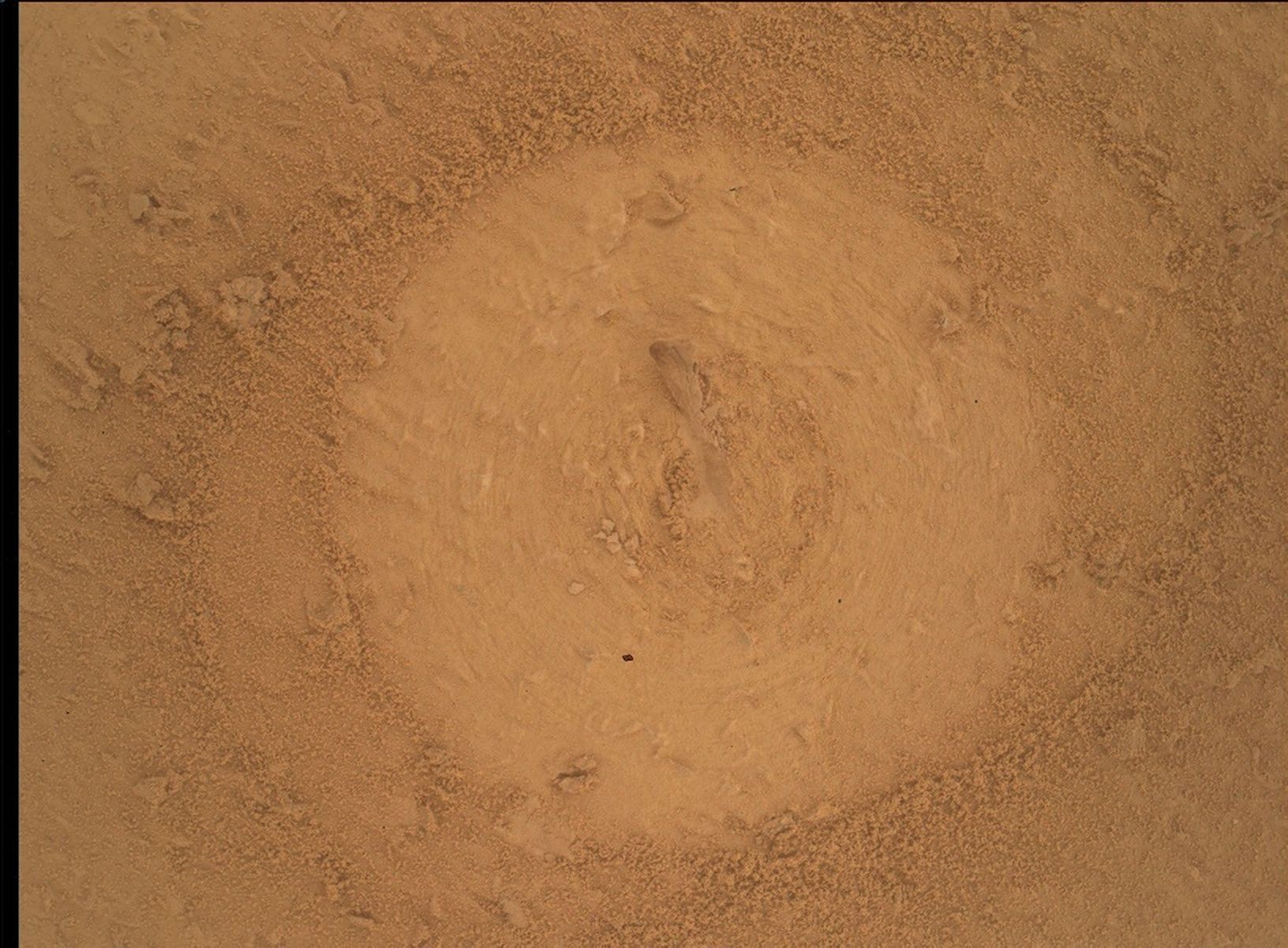
The majority of Curiosity plans involve mosaics from Mastcam and ChemCam, chemistry analyses from ChemCam and APXS, images from MAHLI and MARDI, and systematic measurements from REMS, RAD, and DAN. It is only when we stop to drill that we fully live up to our Mars Science Laboratory designation, using CheMin and SAM to analyze Martian rock. This was one such week, where our focus was wrapping up CheMin analysis of a sample from the “Basque Lakes” drill hole (pictured above), preparing SAM for its analysis, and analyzing the sample with the SAM tunable laser spectrometer (TLS). The CheMin data were key to SAM deciding to analyze the sample at all, and SAM will wait to receive the results from the TLS run (measurement of the volatiles present) to decide if they want to follow up with a separate mass spectrometry analysis next week.
The laboratory activities require a significant portion of the daily power budget of the rover so the rest of the payload largely takes a back seat during drill campaigns, a worthy trade for CheMin and SAM’s valuable data. However, using the power that was available, we gathered data to contextualize our drill location and continued our systematic environmental monitoring. Mastcam acquired a 360-degree mosaic of our surroundings to build a full picture of the geologic setting of the sample. Its color and improved resolution relative to Navcam also guided subsequent science requests, such as more focused Mastcam imaging of structures near the workspace, and ChemCam RMI imaging of the “Cordillera” butte. Mastcam, coupled with Navcam, also planned a series of seven photometry observations spread across fixed times of day. These observations evaluate how the observed spectral characteristics of targets change as the Sun angle on them changes. They help us better interpret images from the rover and from cameras in orbit. ChemCam gathered more chemistry data from the variety of materials in the workspace, from the Basque Lakes drill hole interior, to sand ripples (“French Creek”) covering the bedrock, to loose gray clasts of unknown origin (“Wooley” and “Fireside”) sprinkled across the workspace. Our environmental monitoring activities included regular REMS, RAD, and DAN measurements and Navcam and Mastcam monitoring of dust loading in the atmosphere, cloud activity, and dust-devil activity.

Share
Details
Related Terms
Explore More





A Journey to the Depths of Ancient Mars?
2026-10-06 00:48

Written by Alex Jones, Ph.D. candidate at Imperial College London
Sept. 29, 2026
After spending the last six months exploring “Lac de Charmes,” a region of ancient rock beyond Jezero crater’s western rim, Perseverance has stumbled upon a vast field of light-toned rocks peppering the Martian surface.
Light-colored rocks are a strange sight on Mars, a planet dominated by dark-colored basaltic rocks. This many light-colored rocks in one place piqued the Science Team’s interest… what are they? How did they get here?
To answer the first question, Perseverance has been investigating the composition and textures of these rocks. Data so far indicates that many of them are igneous rocks called gabbro, which are dominated by minerals rich in iron and magnesium. Such rocks typically form by slow cooling and crystallization of magma deep in the crust.
So how did these deep fragments of Mars find their way to the surface?
Perseverance has spent the last week trying to answer this question by investigating a patch of possible bedrock poking out between the light-toned boulders and loose regolith.
Initial images suggest that the rock is made up of light- and dark-colored, angular fragments of rock, forming what geologists call a breccia. One possibility the team is investigating is that the light-toned boulders scattered across the hillside have eroded out of this breccia.

Breccias often form through violent processes involving the fracturing and transport of rock to produce their angular shapes. Layers of breccia observed outside Jezero have previously been attributed to asteroid impacts on early Mars. Perhaps similar impacts (or the Jezero impact itself?) could be responsible for digging up these light-colored blocks.
Only time (and of course, Perseverance), will tell.

Explore More

NASA to Stream SpaceX Crew-12 Return, Splashdown Live
2026-10-05 21:44

NASA and SpaceX are targeting no earlier than 8:05 a.m. EDT, Wednesday, Oct. 7, for the undocking of the agency’s SpaceX Crew-12 mission from the International Space Station, pending weather conditions.
An Oct. 7 undock puts NASA astronauts Jessica Meir and Jack Hathaway, ESA (European Space Agency) astronaut Sophie Adenot, and Roscosmos cosmonaut Andrey Fedyaev on schedule to splash down off the coast of California at approximately 11:34 a.m. on Thursday, Oct. 8.
NASA’s live Crew-12 return coverage will stream through a variety of platforms. Learn where to watch online:
Mission managers continue monitoring conditions in the recovery area, as undocking of the SpaceX Dragon depends on spacecraft readiness, recovery team readiness, weather conditions in the Pacific off the coast of California, and other factors.
NASA’s coverage is as follows (all times Eastern and subject to change based on real-time operations):
Wednesday, Oct. 7
6 a.m.: Hatch closure coverage begins
6:20 a.m.: Hatch closing
7:45 a.m.: Undocking coverage begins
8:05 a.m.: Undocking
Following the conclusion of undocking coverage, NASA will provide audio-only communications between Crew-12, the space station, and flight controllers during Dragon’s transit away from the orbital complex.
Thursday, Oct. 8
10:20 a.m.: Return coverage begins
10:46 a.m.: Deorbit burn
11:34 a.m.: Splashdown
1:15 p.m.: International Space Station briefing for Crew-12 return and SpaceX Commercial Resupply Services-35 launch with the following participants:
- Bill Spetch, deputy manager of Commercial, NASA’s Low Earth Orbit Program
- Dr. Liz Warren, deputy chief scientist, NASA’s Low Earth Orbit Program
- Lee Echerd, senior mission manager, Customer Operations and Integration, SpaceX
- Andreas Mogensen, leader, Human Exploration Group, ESA
To participate virtually in the teleconference, media must contact the NASA Johnson newsroom for call details by 12 p.m., Oct. 8, at: jsccommu@mail.nasa.gov or 281-483-5111. To ask questions, media must dial in no later than 10 minutes before the start of the call. The agency’s media credentialing policy is available online.
For more information about the Crew-12 mission, visit:
https://www.nasa.gov/mission/nasas-spacex-crew-12
-end-
Joshua Finch / Jimi Russell
Headquarters, Washington
202-358-1100
joshua.a.finch@nasa.gov / james.j.russell@nasa.gov
Sandra Jones / Joseph Zakrzewski
Johnson Space Center, Houston
281-483-5111
sandra.p.jones@nasa.gov / joseph.a.zakrzewski@nasa.gov
Steve Siceloff
Kennedy Space Center, Fla.
321-867-2468
steven.p.siceloff@nasa.gov
TechCrunch - Latest
Lucid Motors’ EV output falls to lowest level in almost 2 years
2026-10-05 21:54
OpenAI will start watermarking ChatGPT’s text in the EU
2026-10-05 20:36
Etched fields funding offers at $40B+ valuation, sources say
2026-10-05 20:24
After Factory’s public spat with Khosla, Menlo proudly invests
2026-10-05 19:38
Reflection debuts Beam, an open-weight AI model to rival Chinese models at lower compute cost
2026-10-05 19:33