📰 Trending Topics
Google News - Trending
Google News - Technology
Why Samsung Gave Its Next Folding Phone a New Shape - WIRED
2026-07-22 13:00
- Why Samsung Gave Its Next Folding Phone a New Shape WIRED
- Samsung ups prices as it launches new foldable smartphones ahead of expected Apple debut CNBC
- Samsung’s wider Z Fold 8 feels just right The Verge
- Samsung debuts 3 new foldable phones as Apple readies its own Yahoo Finance
- Samsung Galaxy Z Fold8 Ultra, Fold8 and Flip8: Foldables, Perfected for Every Way of Living Samsung Global Newsroom
Microsoft is bringing original Xbox games to PC - The Verge
2026-07-22 15:00
- Microsoft is bringing original Xbox games to PC The Verge
- Play More of the Games You Love, Wherever You Play with XBOX Backward Compatibility on PC XBOX Wire
- Microsoft Announces Xbox Backward Compatibility on PC, With New Features and Achievements IGN
- Microsoft Is Officially Bringing Achievements To 'Select' Original Xbox Games Pure Xbox
- Xbox Brings OG Console Games to PC, and There’s a Good Reason Why Gizmodo
Apple Plans Overhaul of MacBooks, iMac in Push to Meet AI Demand - Bloomberg.com
2026-07-22 14:30
- Apple Plans Overhaul of MacBooks, iMac in Push to Meet AI Demand Bloomberg.com
- AAPL Plans Major MacBook, iMac Overhaul To Capitalize On AI-Fueled Demand For High-Performance Devices Yahoo Finance
- Apple's Rumored Upgrades To Its Mac Lineup Go Beyond Touchscreens Engadget
- Upgraded Mac Mini, Mac Studio, and OLED iMac are all in the pipeline AppleInsider
- Apple to Overhaul Mac Lineup With 11 New Models MacRumors
A week with the Samsung Galaxy Watch Ultra 2: Big, bright and sometimes helpful - Engadget
2026-07-22 13:00
- A week with the Samsung Galaxy Watch Ultra 2: Big, bright and sometimes helpful Engadget
- Samsung announces Galaxy Watch 9 and Ultra 2, with new AI features Mashable
- [Galaxy Unpacked July 2026] A First Look at Galaxy Watch Ultra2 and Galaxy Watch9 Samsung Global Newsroom
- Samsung’s Galaxy Watch 9 and Ultra 2 bet big on battery The Verge
- Samsung's Galaxy Watch Ultra 2 Is Both Slimmer And Tougher Than Its Predecessor Engadget
Google is making it easier to switch from iPhone to Android - TechCrunch
2026-07-22 17:08
- Google is making it easier to switch from iPhone to Android TechCrunch
- Switch to Android easily — and bring your data with you. blog.google
- Some Pixel phones will miss out on Android 17's new-and-improved iOS migration tool Android Authority
- Google upgrades Android's migration tool to transfer passwords and eSIM from iPhone Neowin
- Google Makes It Super Easy to Switch From iPhone to Galaxy Z Fold 8 Droid Life
NASA - Breaking News
NASA to Showcase Agency’s Newest Wind Tunnel in Virginia
2026-07-22 18:47
Media are invited to NASA’s Langley Research Center in Hampton, Virginia, on Friday, July 31, to attend a media tour and ribbon-cutting ceremony for the Flight Dynamics Research Facility, the agency’s first new wind tunnel in more than 40 years.
The event will include a brief media availability with:
- NASA Administrator Jared Isaacman
- Dr. Trina Dyal, center director, NASA Langley
- Administrator Edward C. Forst, U.S. General Services Administration
This event is in person only and open to members of the media who are United States citizens or lawful permanent residents. Information about timing will be shared closer to the event. NASA’s media accreditation policy is available online.
Media requesting to participate in person must RSVP no later than 5 p.m. EDT on Wednesday, July 29. Media RSVPs must be sent to Kimiko Booker, kimiko.s.booker@nasa.gov, and Brittny McGraw, brittny.v.mcgraw@nasa.gov, with the following information:
- Legal first and last names (must match government identification)
- Phone number
- Job title and organization
The wind tunnel opening marks a major milestone in the evolution of NASA and the nation’s aeronautics and space research capabilities. The state-of-the-art facility will support research and technology development that will advance NASA’s aeronautics, exploration, and science goals, including establishing a sustained human presence on the lunar surface through the Artemis program and the development of a Moon Base.
Learn more about the Flight Dynamics Research Facility at:
-end-
Camille Gallo / Rob Margetta
Headquarters, Washington
202-358-1600
camille.m.gallo@nasa.gov / robert.j.margetta@nasa.gov
Kimiko Booker / Brittny McGraw
NASA Langley, Hampton, Va.
757-506-5939 / 757-769-3763
kimiko.s.booker@nasa.gov / brittny.v.mcgraw@nasa.gov
Robotic Servicing Mission Launches with NASA Support
2026-07-22 18:04
Following its liftoff from Cape Canaveral on July 21 aboard a SpaceX Falcon 9 rocket, the Mission Robotic Vehicle (MRV) hosting the NASA-supported Robotic Servicing of Geosynchronous Satellites (RSGS) payload is now en route to geosynchronous Earth orbit, where it will use its advanced robotics to service spacecraft.
RSGS leverages in-space robotics expertise from NASA, aligned with the agency’s broader goals to advance U.S. capabilities for in-space servicing, assembly, and manufacturing that can be applied to space commerce and exploration.
Funded by the Defense Advanced Research Projects Agency (DARPA), the RSGS program uses twin dexterous robotic arms designed and developed by the U.S. Naval Research Laboratory. DARPA provided the robotic arm assembly for integration onto Northrop Grumman’s MRV, the nation’s first multi-mission robotic in-space servicer. The spacecraft will inspect and upgrade satellites in orbit by installing small propulsion modules – called mission extension pods – extending the operational life of existing spacecraft for years.
RSGS brings together government agencies and industry to test advanced robotic systems in space. NASA’s Goddard Space Flight Center in Greenbelt, Maryland, began supporting the RSGS mission in 2024 under an interagency agreement with DARPA.
NASA’s contributions to the mission leverage its legacy of servicing missions including the Hubble Space Telescope servicing missions and the Robotic Refueling Missions on the International Space Station. NASA support to RSGS program includes the development of dynamic simulation and analysis tools, software analysis for performance verification, and a team of flight robot operators who will support highly technical procedures in orbit. Hundreds of satellites are in geosynchronous orbit. Of those, fully functional satellites are often decommissioned early because they run out of fuel or their equipment becomes obsolete. RSGS establishes a critical U.S. capability to extend the lifetime of spacecraft in orbit, allowing for more innovative and cost-effective mission designs.
By Colleen Wouters
NASA’s Goddard Space Flight Center, Greenbelt, Md.
Share
Details
Related Terms
NASA Sets Coverage for Astronaut Chris Williams, Crewmates Return
2026-07-22 17:17
NASA astronaut Chris Williams and Roscosmos cosmonauts Sergey Kud-Sverchkov and Sergei Mikaev are wrapping up their 241‑day mission aboard the International Space Station.
The crew and its Soyuz MS-28 spacecraft will undock from the orbiting laboratory’s Rassvet module at 3:02 a.m. EDT Sunday, July 26, heading for a parachute-assisted landing at 6:26 a.m. (3:26 p.m. local time) on the steppe of Kazakhstan, southeast of Dzhezkazgan.
NASA’s live return coverage will stream through a variety of platforms. Learn where to watch online:
Williams and his crewmates will complete 3,856 orbits and travel more than 102 million miles before returning to Earth. The flight marks the first mission for Williams and Mikaev and the second for Kud‑Sverchkov.
After landing, the crew will fly by helicopter to Karaganda, Kazakhstan, where recovery teams are based. Williams then will return to NASA’s Johnson Space Center in Houston, while Kud‑Sverchkov and Mikaev head back to their training base in Star City, Russia.
NASA’s live return coverage is as follows (all times Eastern and subject to change based on real-time operations):
Saturday, July 25
9:40 a.m. – Coverage of the Space Station Expedition 74/75 change of command ceremony begins.
Kud‑Sverchkov will transfer command of the orbital complex to NASA astronaut Jessica Meir. Expedition 75 officially begins when Soyuz MS‑28 undocks.
11:10 p.m. – Coverage of crew farewells and hatch closing begins.
11:30 p.m. – Hatch closing
Sunday, July 26
2:30 a.m. – Coverage of undocking begins.
3:02 a.m. – Undocking
5:15 a.m. – Coverage of deorbit and landing begins.
5:32 a.m. – Deorbit burn
6:26 a.m. – Landing
For more than 25 years, people have lived and worked continuously aboard the International Space Station, advancing scientific knowledge and making research breakthroughs not possible on Earth. The space station helps NASA understand and overcome the challenges of human spaceflight, expand commercial opportunities in low Earth orbit, and build on the foundation for long-duration missions to the Moon, as part of the Artemis program, and to Mars.
To learn more about International Space Station research, operations, and its crews, visit:
-end-
Joshua Finch / Jimi Russell
Headquarters, Washington
202-358-1100
joshua.a.finch@nasa.gov / james.j.russell@nasa.gov
Leah Cheshier / Anna Schneider
Johnson Space Center, Houston
281-483-5111
leah.d.cheshier@nasa.gov / anna.c.schneider@nasa.gov
A New Look – and Sound – for Messier 94
2026-07-22 16:45
NASA’s Chandra X-ray Observatory unveiled this new look at the galaxy NGC 4736, also known as Messier 94, on June 30, 2026. Messier 94 is a spiral galaxy with a bright inner ring around it, called a starburst ring, where new stars are forming, perhaps fueled by gas driven in the unique oval-shaped structure seen here.
In this image, X-rays of different wavelengths from Chandra (red, orange, and blue) are layered with a visible light image from astrophotographers using their telescopes on the ground (red, green, and blue).
Experience this image through sound.
Image credit: X-ray: NASA/CXC/SAO; Optical:Brian Brennan and Remi Lacasse; Image Processing: NASA/CXC/SAO/L. Frattare and K. Arcand
Mapping Io’s Hidden Heat With NASA’s Juno
2026-07-22 15:00
Mapping Io’s Hidden Heat With NASA’s Juno
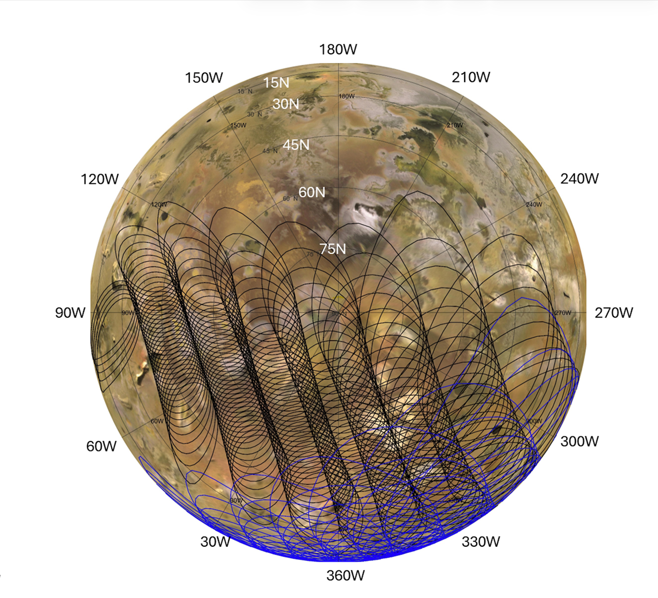
NASA/JPL-Caltech/SwRI/USGS
Description
This graphic illustrates the areas of Jupiter’s moon Io sampled by the Microwave Radiometer (MWR) instrument aboard NASA’s Juno spacecraft during two close flybys. The black overlapping lines show the instrument’s footprints during Perijove 57 on Dec. 30, 2023, when the spacecraft primarily mapped the northern hemisphere. The blue lines represent Perijove 58 on Feb. 3, 2024, which focused heavily on the moon’s mid-latitudes and equatorial regions.
Both passes mapped the side of Io that constantly faces Jupiter. The sweeping, overlapping patterns are a result of the spacecraft spinning at two revolutions per minute as it flew past the moon at a distance of roughly 930 miles (1,500 kilometers).
NASA’s Jet Propulsion Laboratory, a division of Caltech in Pasadena, California, manages the Juno mission for the principal investigator, Scott Bolton, of the Southwest Research Institute in San Antonio. Juno is part of NASA’s New Frontiers Program, which is managed at NASA’s Marshall Space Flight Center in Huntsville, Alabama, for the agency’s Science Mission Directorate in Washington. The MWR was built by JPL. Lockheed Martin Space in Denver built and operates the spacecraft.
More information about Juno is at: http://www.nasa.gov/juno and http://missionjuno.swri.edu


TechCrunch - Latest
Google justifies its massive AI spending with a booming cloud business
2026-07-22 22:01
Treasury threatens sanctions after White House claims Moonshot distilled Anthropic’s Fable
2026-07-22 20:49
Tesla spending skyrockets as Cybercab, Semi, Megapack production timeline slips
2026-07-22 20:43
Social media addiction lawsuit against Meta is dropped
2026-07-22 20:36
SoundCloud acquires decentralized music platform Nina Protocol months after its shutdown
2026-07-22 19:42