📰 Trending Topics
Google News - Trending
Google News - Technology
New Apple TV 4K, HomeView, and HomePod Mini: 16 Details Just Leaked - MacRumors
2026-10-11 19:56
- New Apple TV 4K, HomeView, and HomePod Mini: 16 Details Just Leaked MacRumors
- Apple Is About to Close the Biggest Hole In Its Ecosystem With HomeView Bloomberg.com
- Apple’s New Smart Home Hub Is Reportedly Called HomeView and Will Ship in November CNET
- What to expect from Apple's October 13 'Welcome home' releases AppleInsider
- ‘HomePad’ is coming next week, with three features I’ve long wanted 9to5Mac
Google TV Streamer’s sequel showcases a struggling smart home - 9to5Google
2026-10-11 13:00
- Google TV Streamer’s sequel showcases a struggling smart home 9to5Google
- Next-gen Google TV Streamer in the works with microphones, presence sensing, & new remote 9to5Google
- Google's next TV Streamer sounds like a massive upgrade — Apple should be worried Android Central
- Google is giving its TV box ears, better hardware, and a new bag of tricks Digital Trends
- Next Google TV Streamer to reportedly feature faster chip, built-in microphone FlatpanelsHD
The original Apple TV 4K from 2017 is now officially "vintage" - GSMArena.com news - GSMArena.com
2026-10-11 17:31
- The original Apple TV 4K from 2017 is now officially "vintage" - GSMArena.com news GSMArena.com
- The new Apple TV could have a built-in mic and a remote with a speaker The Verge
- New Apple TV 4K and HomePod Mini to Ship on October 30 MacRumors
- Apple testing two new features for upgraded Apple TV 4K, per report 9to5Mac
- New HomePod mini and Apple TV will debut during HomeView launch AppleInsider
Today's NYT Strands Hints (and Answer) for Sunday, October 11, 2026 - Lifehacker
2026-10-11 23:01
- Today's NYT Strands Hints (and Answer) for Sunday, October 11, 2026 Lifehacker
- NYT Strands Hints for October 12, 2026 The New York Times
- Today’s NYT Strands Hints, Spangram and Answers for Monday, Oct. 12, #953 CNET
- NYT Strands Hint Today: Sunday, October 11 Spangram And Answers Forbes
- Today’s NYT Strands answers, clues, and hints on October 10 (puzzle #951) PC Guide
Margaret Hamilton, computing pioneer who led software development for the Apollo program, dies at 90 - MIT News
2026-10-07 20:55
- Margaret Hamilton, computing pioneer who led software development for the Apollo program, dies at 90 MIT News
- Margaret Hamilton, Who Developed Software for First Moon Landing, Dies at 90 WSJ
- Margaret Hamilton, whose software helped land Apollo astronauts on the moon, has died CNN
- Before Computer Science Became a Boys’ Club, Margaret Hamilton Wrote the Code The New York Times
- Margaret Hamilton, who led a software team for NASA’s Apollo program, dies at 90 NBC News
NASA - Breaking News
APOD: 2026 October 12 – Jupiter and the Moons
2026-10-12 04:05
APOD
Astronomy Picture of the Day
Discover the cosmos! Each day a different image or photograph of our fascinating universe is featured, along with a brief explanation written by a professional astronomer.
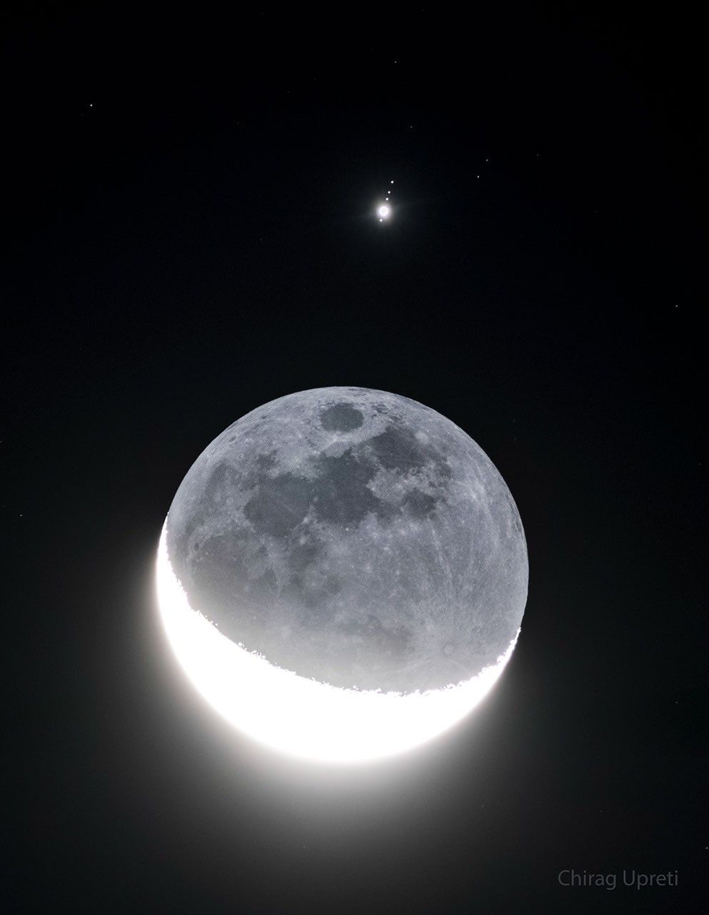
Jupiter and the Moons
Explanation: How many moons can you see? The best answer is five: four orbiting Jupiter and Luna orbiting Earth. This multi-moon picture was possible because Earth’s Moon moved directly in front of Jupiter last week. The featured image is a series of exposures near alignment taken from Westchester, New York, USA. The sunlit crescent of Earth’s Moon, on the lower left, is overexposed, while the Moon’s night side, on the upper right, is faintly illuminated by Earthshine. Lined up nearly vertically above our Moon, listed from bottom to top, are Jupiter’s bright Galilean satellites: Ganymede, Io, Callisto, and Europa. Callisto, Ganymede, and Io are larger than Earth’s Moon, while Europa is only slightly smaller. NASA’s robotic spacecraft Juno is currently orbiting Jupiter and has made close passes near three of these moons.
Tomorrow’s picture: stairway to heaven
| Date: | October 12, 2026 |
|---|---|
| Credit & Copyright: | Chirag Upreti |
| Authors & editors: | Robert Nemiroff, Jerry Bonnell, Cecilia Chirenti, Keighley Rockcliffe |
| A service of: |
ASD at NASA / GSFC, NASA Science Activation & Michigan Tech. U. |
Antarctic Sea Ice Grows to Its 2026 Maximum
2026-10-12 04:00
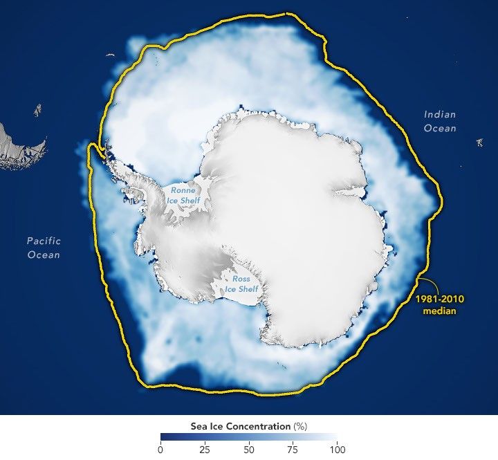
This story is an update to the Antarctic sea ice feature in our World of Change series tracking long-term change on Earth’s surface through satellite imagery.
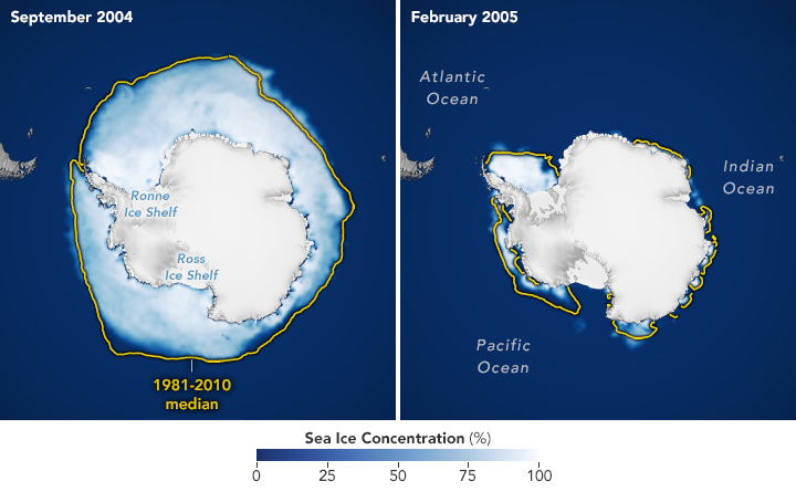
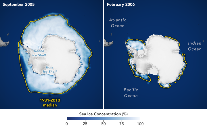
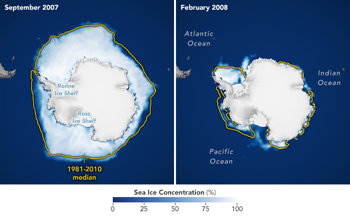
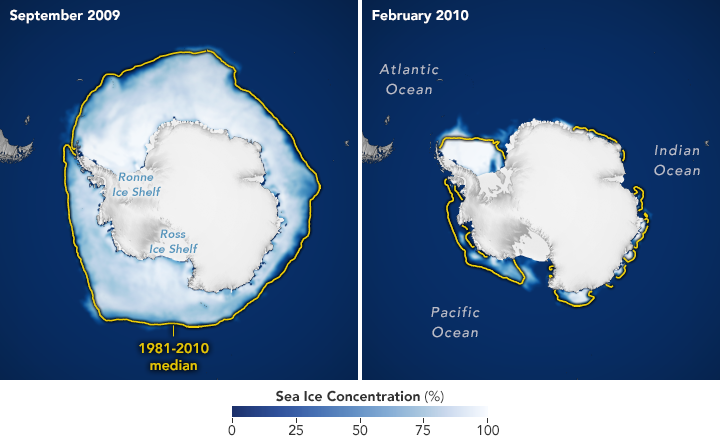
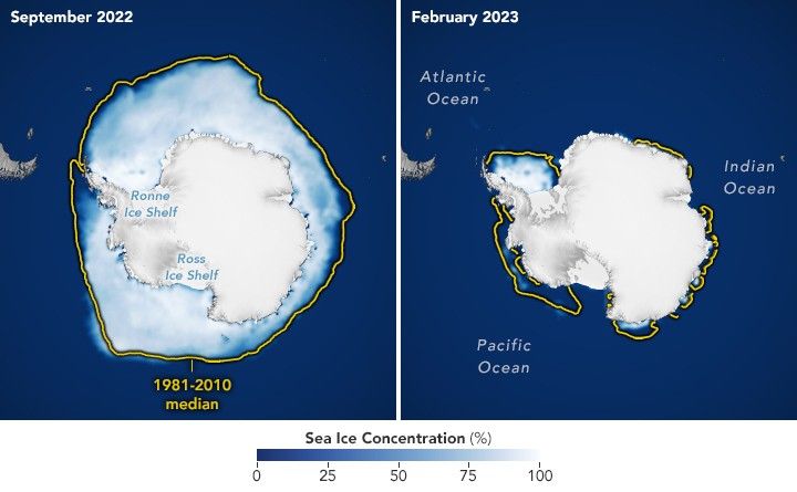
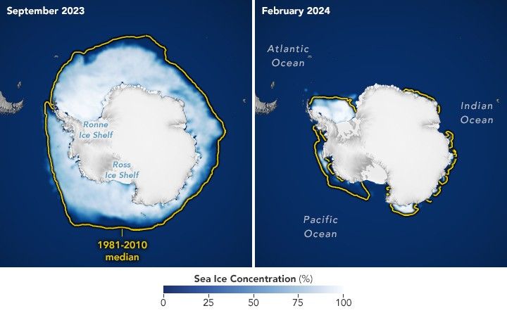
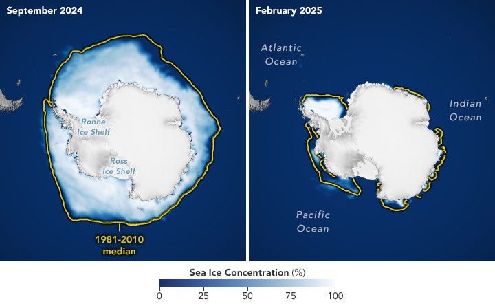
Unlike the Arctic—an ocean basin surrounded by land—the Antarctic is a large continent surrounded by an ocean. Because of this geography, sea ice has more room to expand during the winter. However, that ice also stretches into warmer latitudes, leading to more melting in the summer. Antarctic sea ice usually peaks in September, around the end of the Southern Hemisphere’s winter, and retreats to a minimum in February.
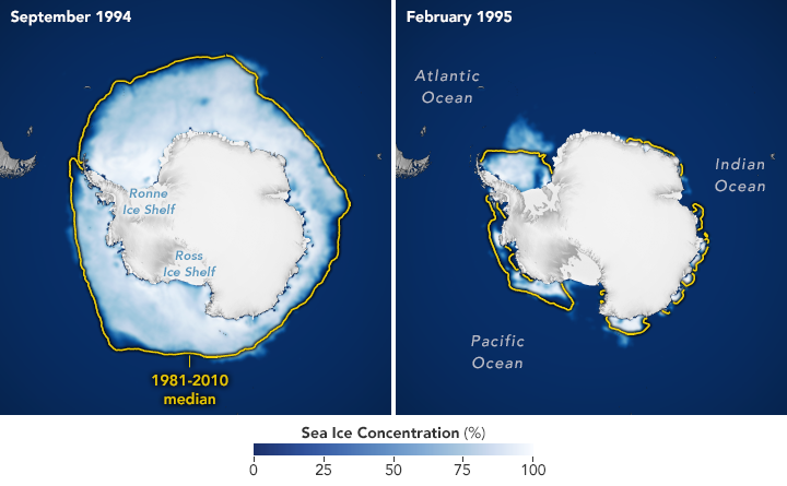
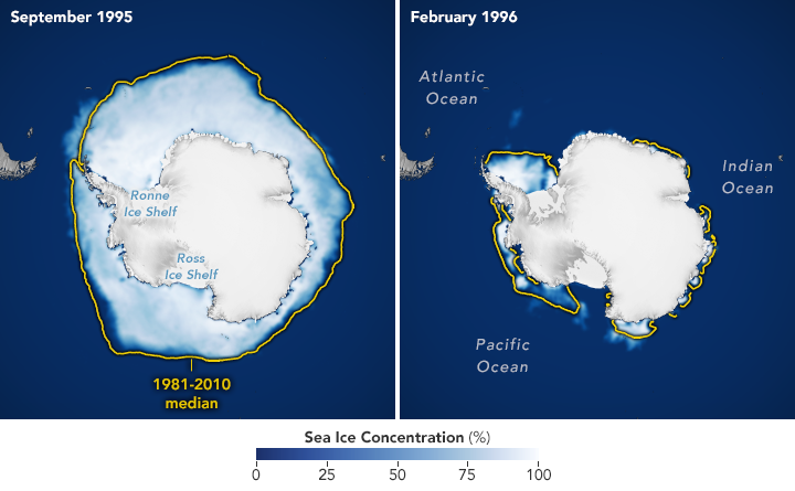
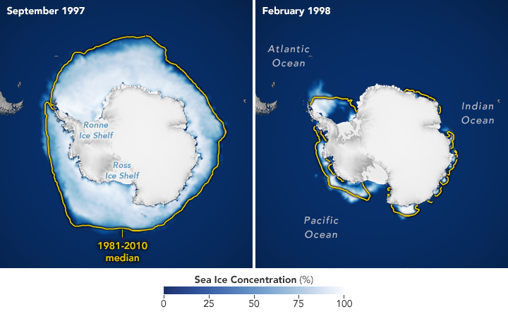
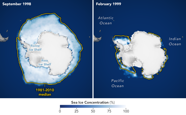
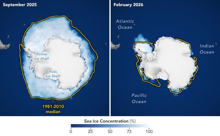
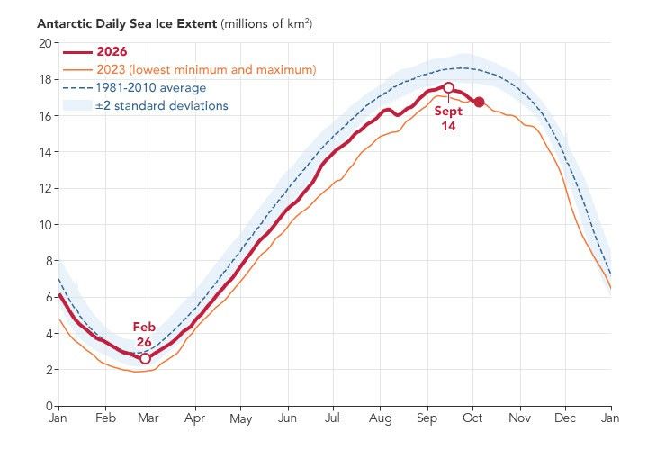
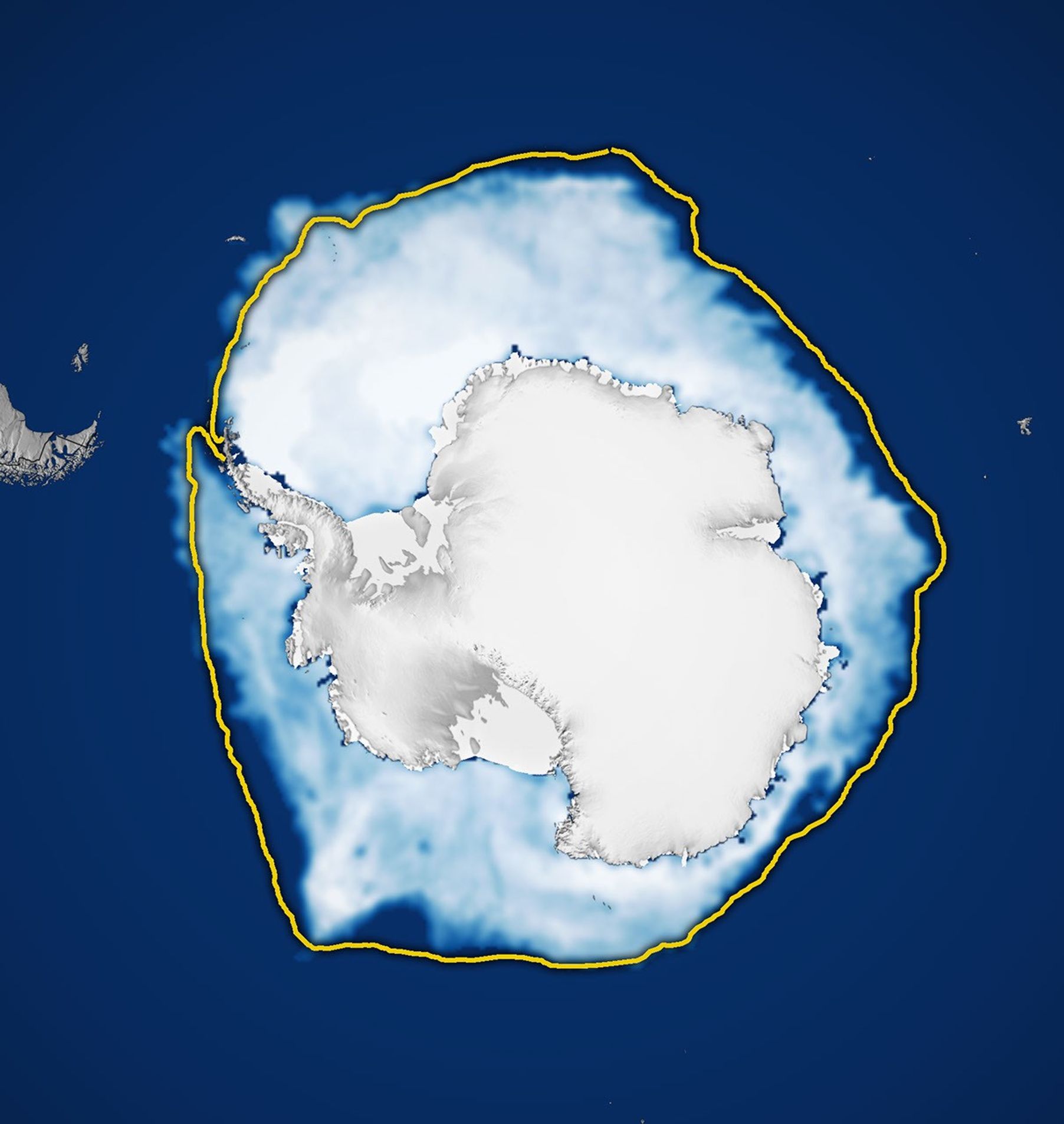
According to NASA and the National Snow and Ice Data Center (NSIDC), Antarctic sea ice in 2026 likely reached its annual maximum extent on September 14 (above). On that date, the ice covered an estimated 17.59 million square kilometers (6.79 million square miles), making it the third-lowest maximum on record.
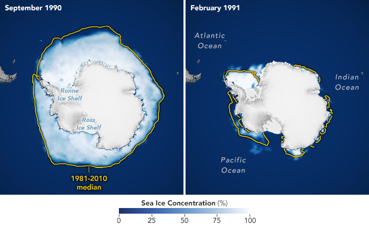
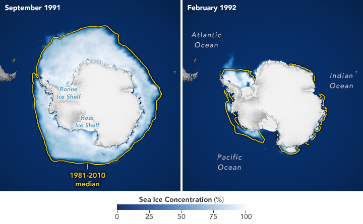
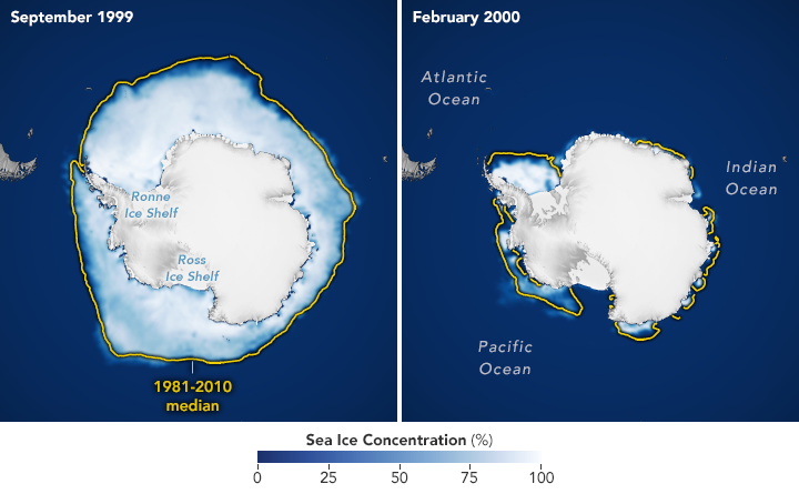
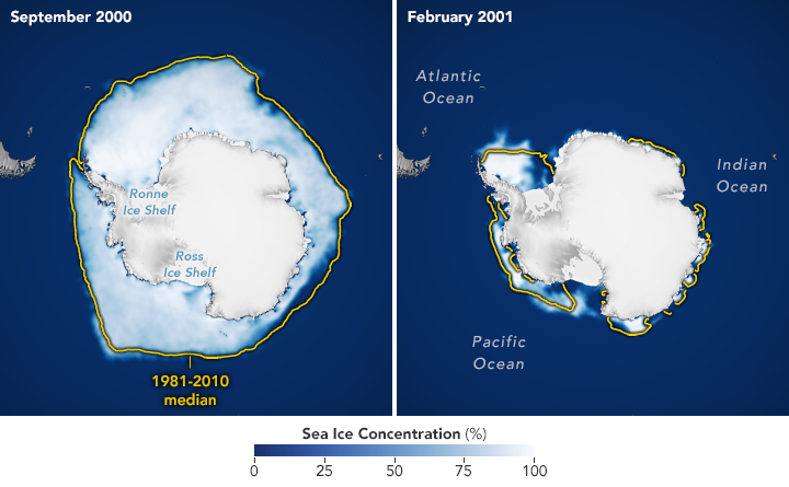
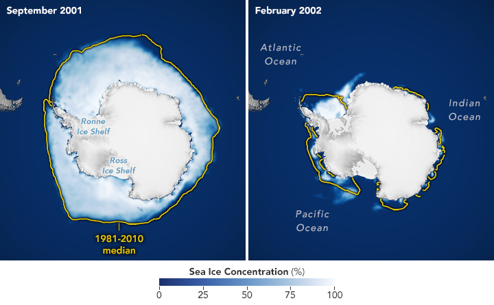
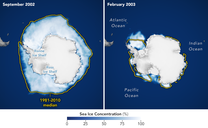
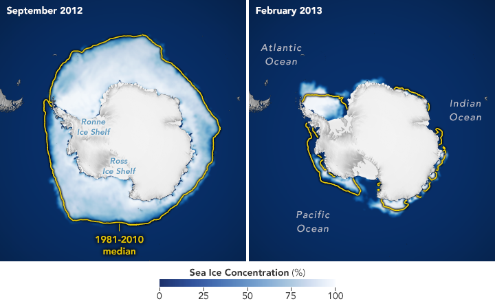
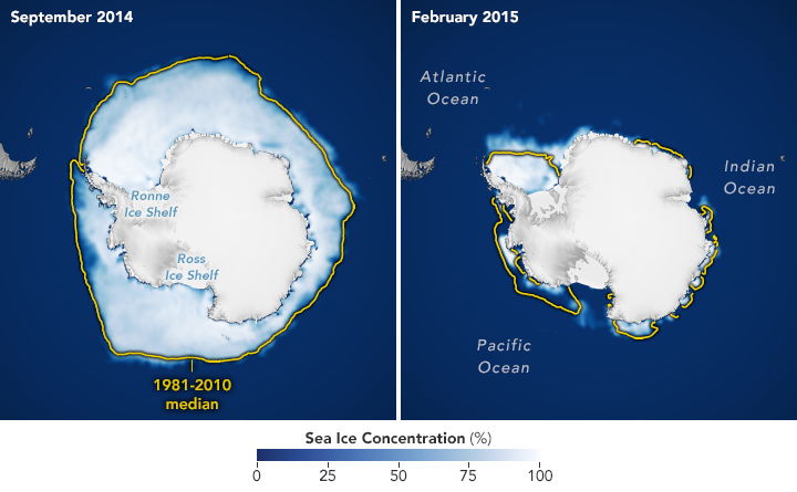
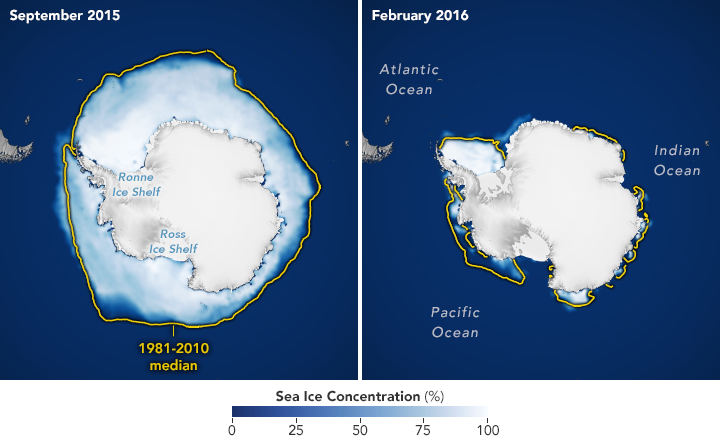
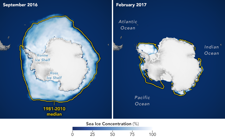
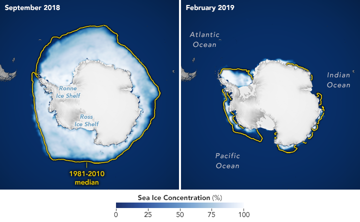
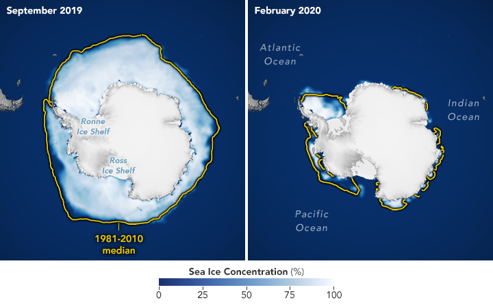
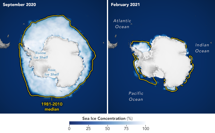
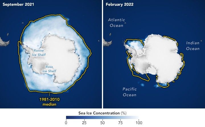
The maps below show the average concentration of Antarctic sea ice for the month of September (left) and the following February (right) from 1990 to 2026. Opaque white areas indicate the highest concentrations, and dark blue areas are open water. The images include only areas where ice concentration was at least 15 percent, a threshold scientists commonly use to count an area as ice-covered in satellite data. Scientists refer to the total area of these regions as the “sea ice extent.”










From Record Highs to Record Lows
From 1979 until 2014, total Antarctic sea ice increased by about 1 percent per decade. Whether the increase was a sign of meaningful change is uncertain because ice extents vary considerably from year to year around Antarctica. For three consecutive years, from 2012 to 2014, satellites observed new record highs for winter sea ice extent. These highs occurred while Arctic ice was in steep decline.
The climb came to an end in 2015, and significant decreases in sea ice around Antarctica started to occur in 2016. There have since been years with small rebounds, but overall, Antarctic sea ice coverage has largely remained lower than normal. Both the record low minimum and record low maximum occurred in 2023. Scientists will continue to observe the area each year to find out if the decline is part of a long-term change or a statistical fluctuation.
Seeing Through the Clouds
To determine sea ice extent, scientists rely on satellites with passive microwave sensors that measure the microwave energy Earth naturally emits. Sea ice emits more of this energy than open water, so it stands out in microwave images. Because microwaves pass through clouds, the satellites can observe sea ice regularly, regardless of weather.
The record began in late 1978 with data collected by NASA’s Nimbus-7, followed by Defense Meteorological Satellite Program (DMSP) satellites starting in 1987, and by NASA’s Aqua satellite between 2002 and 2011. In 2025, scientists began using observations from the Japan Aerospace Exploration Agency’s GCOM-W satellite.
NASA Earth Observatory images by Michala Garrison, using data from the National Snow and Ice Data Center.
References & Resources
- NASA Earthdata (2026, October) Sea Ice. Accessed October 8, 2026.
- NASA Earth Observatory (2026, October 6) World of Change: Antarctic Sea Ice. Accessed October 8, 2026.
- NASA Earth Observatory (2016, September 16) Sea Ice. Accessed October 8, 2026.
- NASA Earth Science (2026, September 23) Arctic Sea Ice Reaches 2026 Annual Minimum Extent. Accessed October 8, 2026.
- National Snow and Ice Data Center (2026, September 23) Arctic sea ice has reached minimum extent for 2026; Antarctic sea ice maximum most likely reached as well. Accessed October 8, 2026.
- National Snow and Ice Data Center (2026, March 9) Antarctic sea ice extent arrives at a near-average minimum. Accessed October 8, 2026.
You may also be interested in:
Stay up-to-date with the latest content from NASA as we explore the universe and discover more about our home planet.
Satellite records show Arctic sea ice covering less of the ocean in both winter and summer.

Experts are analyzing decades of images from Landsat satellites for clues about how the iconic birds have responded to sea…

The color of Adélie penguin droppings reveals what the birds are eating, offering scientists a way to track how sea…




APOD: 2026 October 11 – Ice Fishing for Cosmic Neutrinos
2026-10-11 04:05
APOD
Astronomy Picture of the Day
Discover the cosmos! Each day a different image or photograph of our fascinating universe is featured, along with a brief explanation written by a professional astronomer.
Ice Fishing for Cosmic Neutrinos
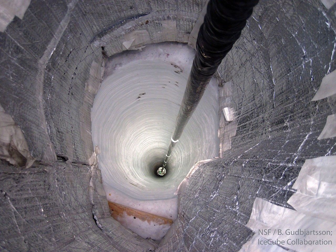
Explanation: Scientists are melting holes in the bottom of the world. In fact, almost 100 holes melted near the South Pole are now being used as an astronomical observatory. Astronomers with the IceCube Neutrino Observatory lowered a long string knotted with basketball-sized light detectors into each vertical lake. The water in each hole soon refreezes. The detectors attached to the strings are sensitive to blue light emitted in the surrounding clear ice. Such light results from fast-moving secondary particles liberated when high-energy neutrinos emitted by powerful processes out in the universe collide with ice molecules. IceCube has now detected many illuminating neutrinos. Pictured in 2010, one of the last of IceCube’s detector strings is lowered into the freezing abyss, making IceCube the largest neutrino detector ever created. In recognition of unprecedented discoveries, it was announced earlier this week that a founding leader of the IceCube Collaboration will be awarded the Nobel Prize in Physics.
Tomorrow’s picture: Moons Planet
| Date: | October 11, 2026 |
|---|---|
| Credit: | NSF, B. Gudbjartsson, IceCube Collaboration |
| Authors & editors: | Robert Nemiroff, Jerry Bonnell, Cecilia Chirenti, Keighley Rockcliffe |
| A service of: |
ASD at NASA / GSFC, NASA Science Activation & Michigan Tech. U. |
NASA to Conduct Flyover, Engage NFL Fans at MetLife Stadium
2026-10-10 14:18

As part of the agency’s Inspiration Tour flyover, NASA Administrator Jared Isaacman will pilot one of three F-5 fighter jets to kick off the New York Jets vs. Cleveland Browns game in East Rutherford, New Jersey, on Sunday, Oct. 11.
NASA team members will engage with fans at the agency’s Experience Zone, located at the Jets Tailgate Zone outside the stadium, from 10 a.m. to 1 p.m. EDT before the game. Fans can learn more about NASA’s return to the Moon under the agency’s Artemis dome, enjoy interactive games, and capture photos with a large, inflatable SLS (Space Launch System) rocket.
Isaacman will be available for limited media interviews during the game. To arrange interviews, please contact Camille Gallo at: camille.m.gallo@nasa.gov or 202-531-8057.
With stops across the nation, NASA’s Inspiration Tour convenes academic, industry, and public sector stakeholders to connect the agency with the people, technologies, and organizations that drive American leadership in space.
The tour will culminate in MAX POWER, a public exposition of American air and space innovation, Saturday, Nov. 7, and Sunday, Nov. 8, on and near the agency’s Kennedy Space Center in Florida. Held in honor of America’s historic 250th anniversary, the multi-day, family-friendly event will showcase the next-generation aircraft, spacecraft, autonomous vehicles, and technologies that will help define the future of transportation in air and space.
For more information about MAX POWER and the agency’s missions, visit:
-end-
Camille Gallo / Jessica Taveau
Headquarters, Washington
202-358-1600
camille.m.gallo@nasa.gov / jessica.c.taveau@nasa.gov
APOD: 2026 October 10 – Lunar Farside
2026-10-10 04:05
APOD
Astronomy Picture of the Day
Discover the cosmos! Each day a different image or photograph of our fascinating universe is featured, along with a brief explanation written by a professional astronomer.
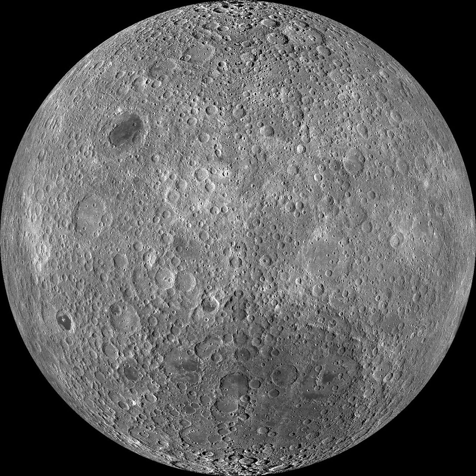
Lunar Farside
Explanation: Tidally locked in synchronous rotation, the Moon always presents its familiar nearside to denizens of planet Earth. From lunar orbit, the Moon’s farside can become familiar, though. In fact this sharp picture, a mosaic from the Lunar Reconnaissance Orbiter’s wide angle camera, is centered on the lunar farside. Part of a global mosaic of over 15,000 images acquired between November 2009 and February 2011, the highest resolution version shows features at a scale of 100 meters per pixel. Surprisingly, the rough and battered surface of the farside looks very different from the nearside covered with smooth dark lunar maria. A likely explanation is that the farside crust is thicker, making it harder for molten material from the interior to flow to the surface and form dark, smooth maria.
Tomorrow’s picture: Sunday’s Childe
| Date: | October 10, 2026 |
|---|---|
| Credit: | NASA / GSFC / Arizona State Univ. / Lunar Reconnaissance Orbiter |
| Authors & editors: | Jerry Bonnell, Cecilia Chirenti, Robert Nemiroff, Keighley Rockcliffe |
| A service of: |
ASD at NASA / GSFC, NASA Science Activation & Michigan Tech. U. |
TechCrunch - Latest
The founder’s guide to TechCrunch Disrupt 2026: Everything you need to know
2026-10-12 00:59
Will the HomeView be Apple’s first smart home success?
2026-10-11 21:14
Aaron Sorkin’s ‘Social Reckoning’ is off to a weak start
2026-10-11 20:51
48 hours to TechCrunch Disrupt 2026 — hear directly from the people building what’s next
2026-10-11 19:00
The investor’s guide to TechCrunch Disrupt 2026: Everything you need to know
2026-10-11 17:53