📰 Trending Topics
Google News - Trending
Google News - Technology
Major Windows 11 update will make 8GB RAM laptops much better to use - Windows Central
2026-07-31 16:46
- Major Windows 11 update will make 8GB RAM laptops much better to use Windows Central
- Windows quality: an update on the commitment we made in March Windows Blog
- Microsoft Promises Better Windows 11 Memory Efficiency TechPowerUp
- Windows 11’s next big priority: Making 8GB PCs less painful to use PCWorld
- Major Windows 11 update will soon make slow context menus a thing of the past Windows Central
See how Google Earth let people make fake scenes of bombings, riots and destruction - washingtonpost.com
2026-08-01 03:30
- See how Google Earth let people make fake scenes of bombings, riots and destruction washingtonpost.com
- Google Just Ruined One of Its Most Important Tools The Atlantic
- Google pauses AI satellite images, after fears of deepfakes in the sky NPR
- Alphabet rolls back AI image generation in Google Earth over policy violations Reuters
- Transform any place with Nano Banana in Google Earth blog.google
Sony Heard Backlash Over Dropping PlayStation Discs, Plans to Press Ahead - PCMag
2026-07-31 11:45
- Sony Heard Backlash Over Dropping PlayStation Discs, Plans to Press Ahead PCMag
- Sony acknowledges backlash, “cautiously” moves ahead with end of PlayStation discs Ars Technica
- "It's a sad decision." Clair Obscur: Expedition 33 developers on the end of physical disc production and why they pushed for a physical release despite the drawbacks AUTOMATON
- Minnesota gamers furious after PlayStation says it will stop making game discs MPR News
- Sony Says PlayStation Disc Backlash Not Making ‘Any Impact’ On Business Forbes
Three Recent Chrome Releases Fix 1,442 Flaws, More Than Prior 23 Updates Combined - thehackernews.com
2026-07-31 12:51
- Three Recent Chrome Releases Fix 1,442 Flaws, More Than Prior 23 Updates Combined thehackernews.com
- Stronger with every update: How we’re making Chrome and the web safer in the AI Era blog.google
- Chrome may get faster updates with no restart required Ars Technica
- Google Tests Doubling Chrome's Security Patch Cadence to Outpace Hackers PCMag
- Chrome Needs Twice-a-Week Patching Thanks to AI Bug Hunting WIRED
Marathon PvE Game Mode Beta Gets Extended for Further Testing - TechPowerUp
2026-07-30 05:29
- Marathon PvE Game Mode Beta Gets Extended for Further Testing TechPowerUp
- Marathon’s Vault Breaker disappoints, but there’s still hope for Season 3 TheSixthAxis
- Sony's financial report confirms renewed interest in Marathon GameGPU
- Marathon: Sony's wishful thinking meets reality PlayFront
- Sony thinks Season 2 of Marathon has been a success Instant Gaming News
NASA - Breaking News
APOD: 2026 August 1 – Buck Moon and Belt of Venus
2026-08-01 04:05
APOD
Astronomy Picture of the Day
Discover the cosmos! Each day a different image or photograph of our fascinating universe is featured, along with a brief explanation written by a professional astronomer.

Buck Moon and Belt of Venus
Explanation: The Buck Moon is a traditional name for the full moon of July. In this colorful Adriatic sea and skyscape captured on July 28 from Krk Island along the coast of Croatia, a full Buck Moon is just rising over distant mountains. Since a full moon rises as the Sun sets, Earth’s shadow also rises in the twilight scene, a diffuse gray band extending above the mountainous southeastern horizon. Above Earth’s shadow band is the pinkish antitwilight arch. That subtly tinted band of backscattered sunlight is more widely known as the Belt of Venus. But as it shares the eastern horizon with the atmospheric shadow of Earth and Belt of Venus, this full Buck Moon seems to set the stage for the New Moon to come. The New Moon of August 12 will cast its own shadow on planet Earth in a much anticipated total solar eclipse.
Tomorrow’s picture: fire and rainbow
| Date | August 1, 2026 |
|---|---|
| Credit | Image Credit & Copyright: Branko Nadj |
| Authors & editors: | Robert Nemiroff, Jerry Bonnell, Cecilia Chirenti, Keighley Rockcliffe |
| A service of: |
ASD at NASA / GSFC, NASA Science Activation & Michigan Tech. U. |
What’s Up: August 2026 Skywatching Tips from NASA
2026-07-31 22:35
A solar eclipse, the Perseids, bright Venus after sunset, and a deep partial lunar eclipse highlight August’s skywatching.
Skywatching Highlights
- Aug. 5: Last Quarter Moon
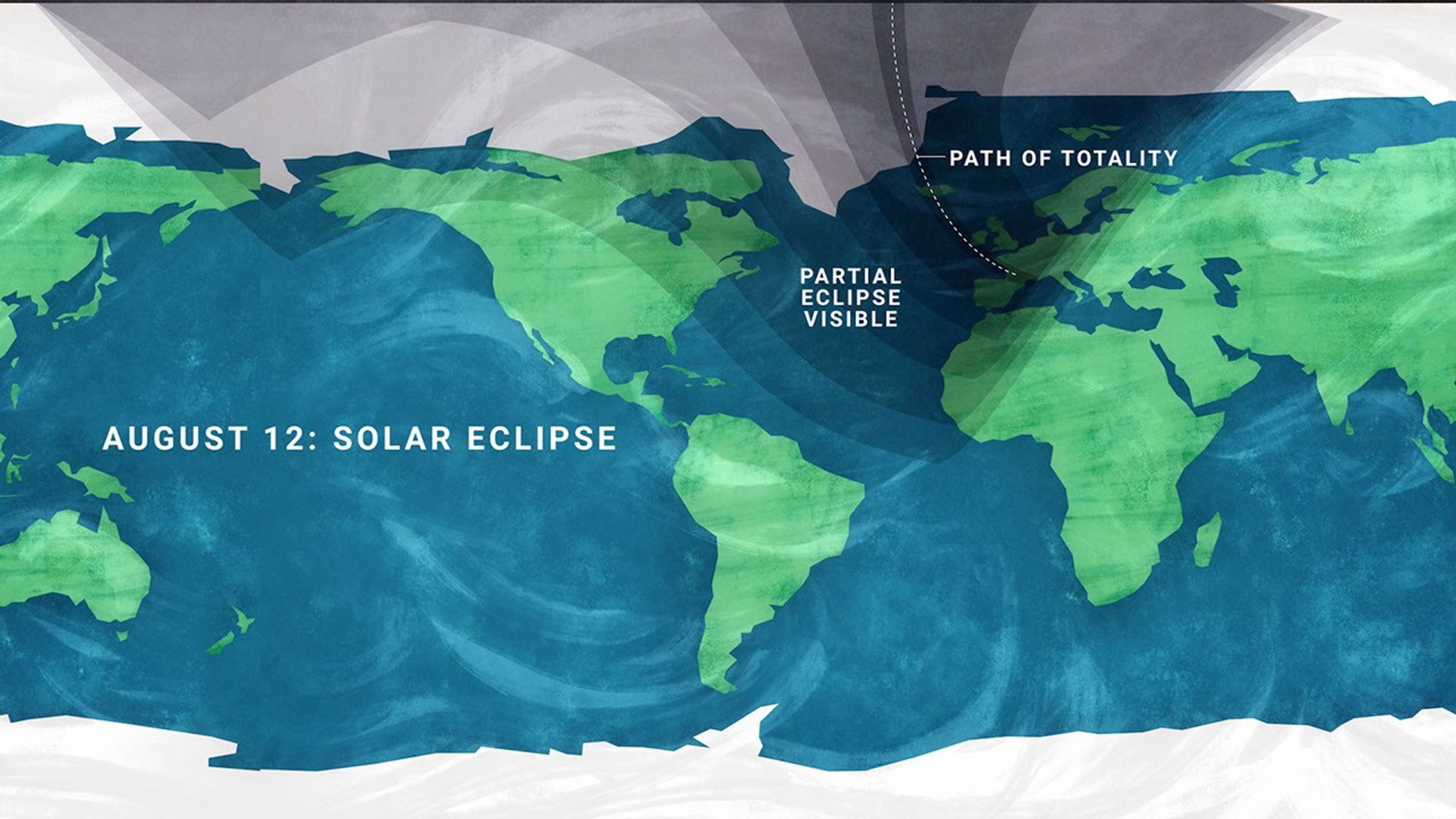
- Aug. 12: Total solar eclipse across northern Russia, Greenland, Iceland, northern Spain, and part of Portugal; partial eclipse in parts of the U.S.; New Moon
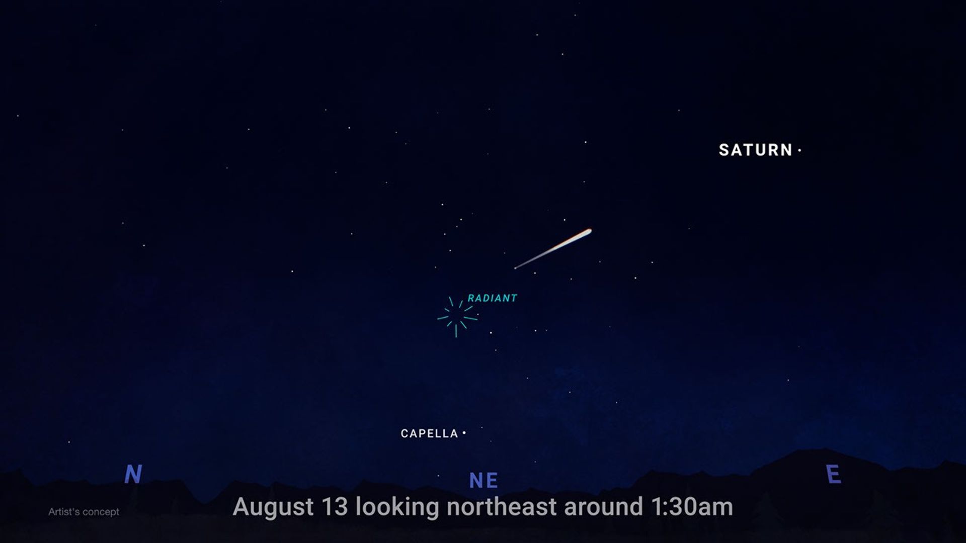
- Aug. 12-13: Perseid meteor shower peak under dark skies
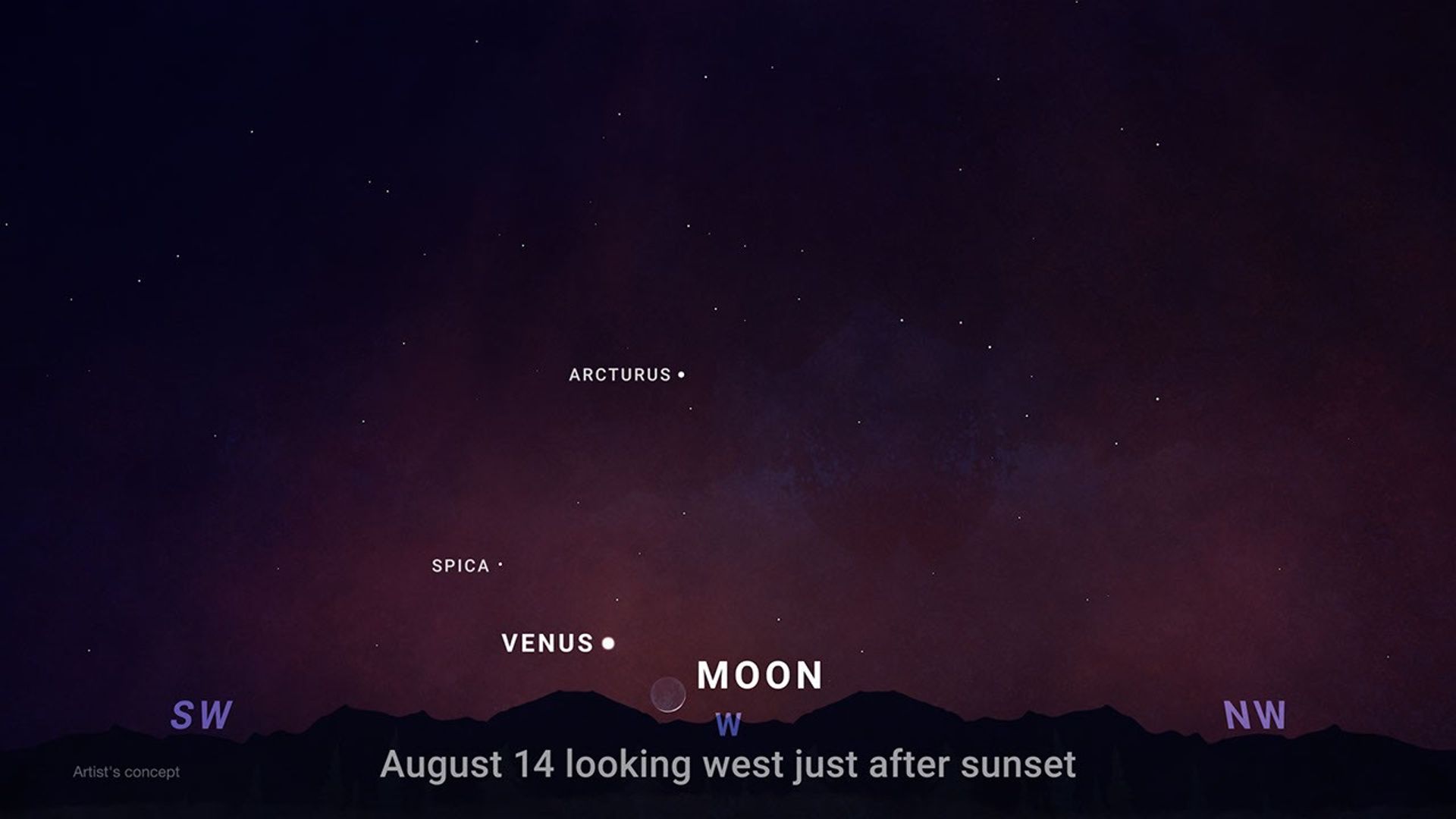
- Aug. 14-16: Venus reaches greatest eastern elongation and shines low in the west after sunset
- Aug. 27-28: Partial lunar eclipse visible from much of North and South America and parts of Europe and Africa
Transcript
A solar eclipse, one of the year’s best meteor showers, Venus at its brightest in the evening sky, and a lunar eclipse to close out the month.
That’s “What’s Up” for August.
On Aug. 12, a total solar eclipse crosses northern Russia, Greenland, Iceland, and northern Spain, with a small corner of Portugal inside the path of totality.
In parts of the United States, from Alaska to North Carolina, the eclipse is partial. The Moon will take only a small bite out of the Sun, and the amount of coverage will vary with location.
Remember to watch safely. Use certified eclipse glasses or a safe solar viewer any time any part of the Sun is visible. Regular sunglasses are not safe. And never use binoculars, a telescope, or a camera without a solar filter made for the front of the optics.
Later that same night, the Perseid meteor shower will light up the sky, peaking the evening of Aug. 12 into the early morning hours of the 13th. And with a New Moon arriving on the 12th, the skies will be ideally dark.
The Perseids happen every year when Earth passes through a debris stream left behind by Comet Swift-Tuttle. As those tiny bits of comet dust hit our atmosphere at high speed, they burn up as bright streaks of light.
To view this meteor shower, look toward the northeast once it’s fully dark and watch for the constellation Perseus to clear the horizon. This is where the meteors originate, but let your eyes wander, because they can flash across any part of the sky.
For the best view, stay out late as the stars climb higher, find a dark open spot, and give your eyes 30 minutes to adjust.
Aug. 14-16, Venus reaches its greatest eastern elongation, which is its widest apparent separation from the Sun during this evening appearance.
Look low in the western sky shortly after sunset for the bright object that will outshine every star around it. Through a telescope after sunset, Venus will look close to half lit, like a tiny lunar phase.
On the night of Aug. 27, continuing into Aug. 28 for some time zones, the Full Moon slips through Earth’s shadow, resulting in a partial lunar eclipse. It will be visible from much of North and South America and parts of Europe and Africa.
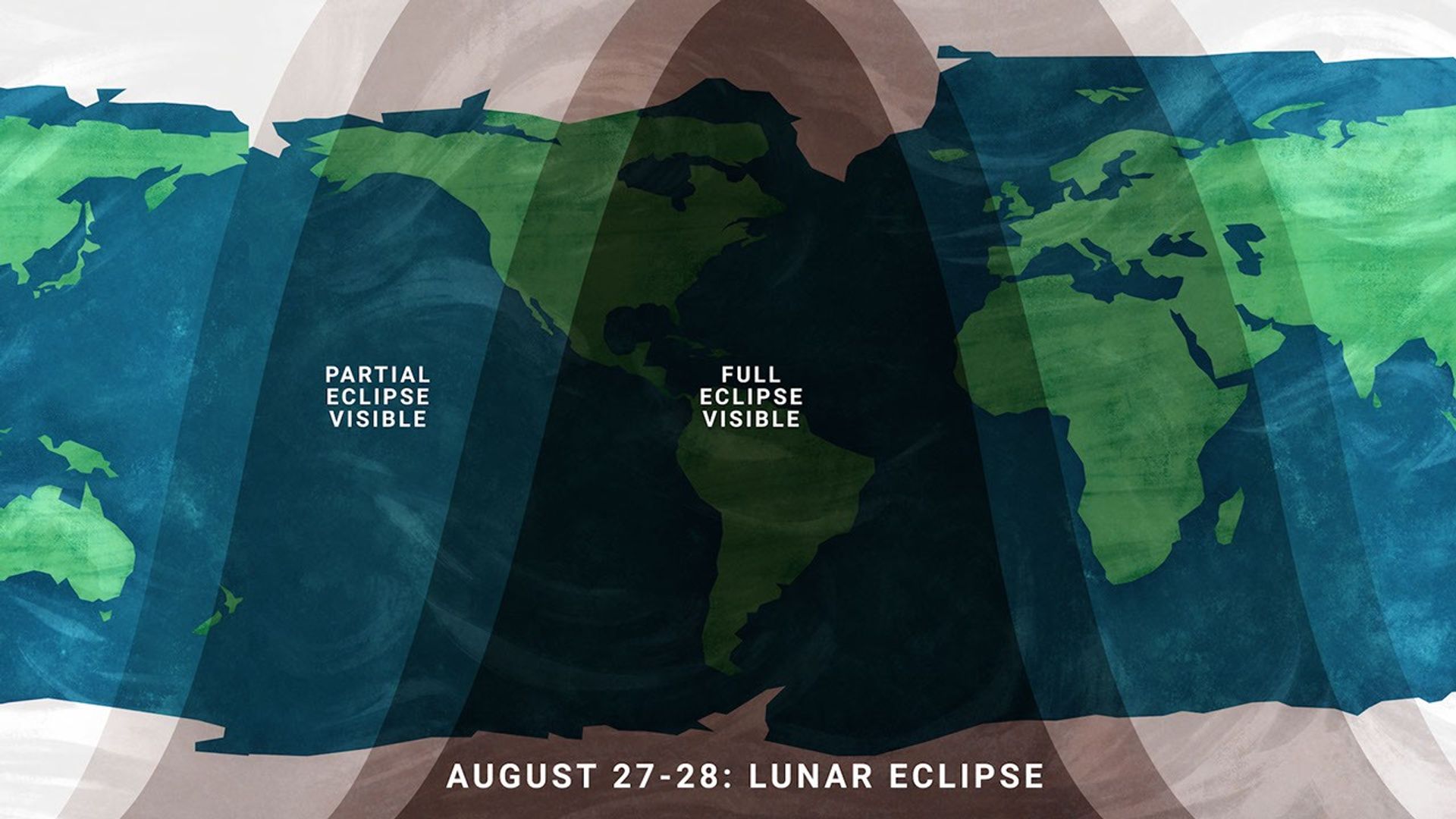
At maximum eclipse, about 93% of the Moon’s diameter will be inside Earth’s dark central shadow, called the umbra. The Moon will not be completely covered, but it can look dramatically darkened, with a rusty, coppery tint along the covered edge.
Unlike a solar eclipse, a lunar eclipse is safe to watch with just your eyes. Binoculars or a small telescope can give you a closer view of Earth’s curved shadow moving across the Moon.
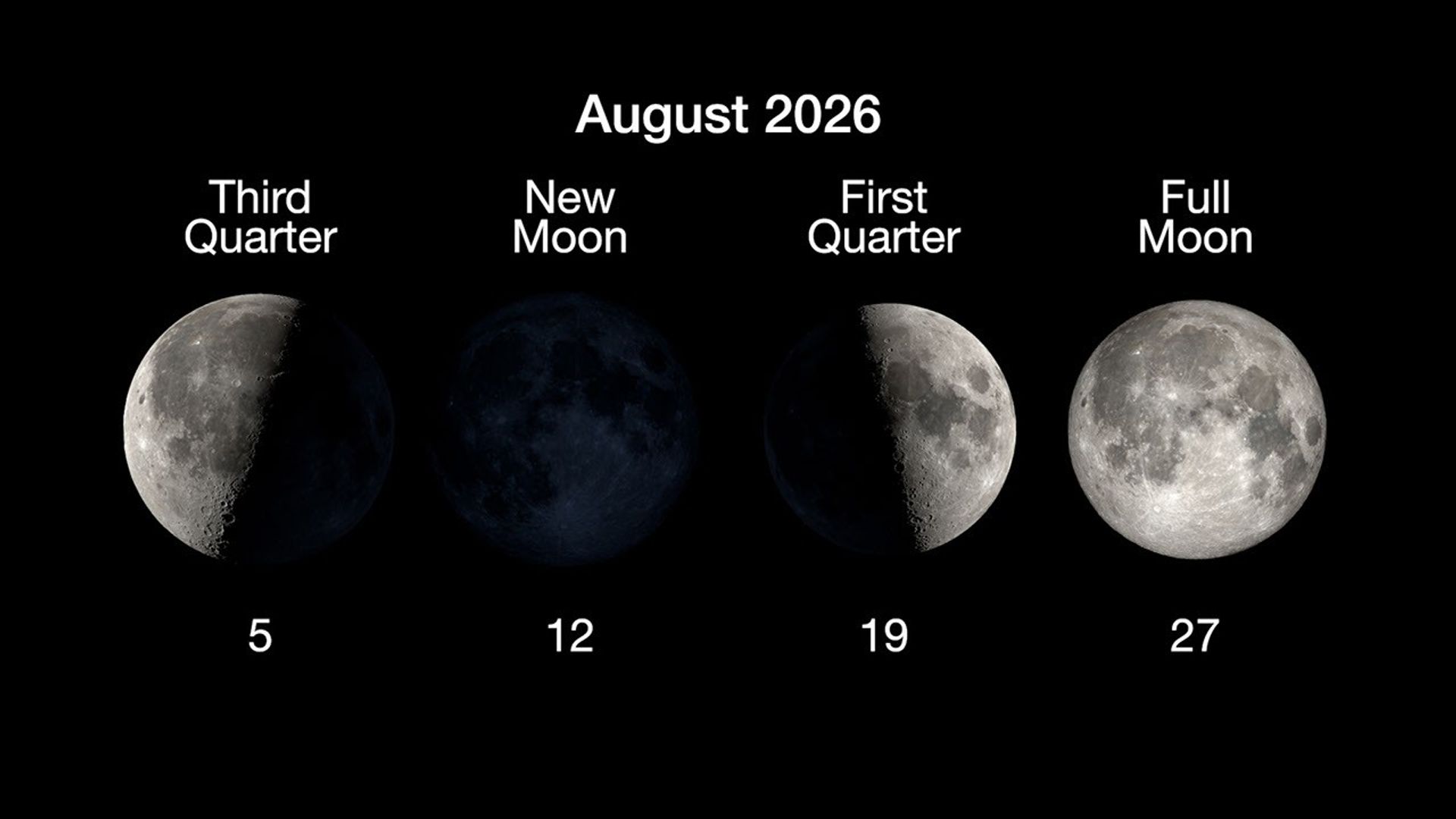
Here are the phases of the Moon for August.
You can stay up to date on all of NASA’s missions exploring the solar system and beyond at science.nasa.gov. I’m Raquel Villanueva from NASA’s Jet Propulsion Laboratory, and that’s What’s Up for this month.
Share
Details
Related Terms

NASA to Host Florida Event Celebrating American Air, Space Leadership
2026-07-31 21:08
NASA will hold a news conference at 2:30 p.m. EDT, Friday, Aug. 14, live from the agency’s Kennedy Space Center in Florida, and media and digital creators are invited to attend in person.
The announcement, held in the XLV Hangar at the Shuttle Landing Facility, will preview a new event at NASA Kennedy later this year tied to America’s 250th anniversary, showcasing American leadership in aviation, space exploration, and emerging technologies while bringing together the public, industry leaders, innovators, and the next generation of explorers.
Participants include:
- NASA Administrator Jared Isaacman
- NASA leadership
- Members of Congress
The agency will stream this news conference live through a variety of platforms:
This event is open to U.S. media and digital creators. The request to attend must be received no later than 12 p.m. on Thursday, Aug. 6, to the Kennedy newsroom at: https://media.ksc.nasa.gov. NASA’s media accreditation policy is available online.
For more information about NASA’s missions, visit:
-end-
George Alderman / Cheryl Warner
Headquarters, Washington
202-358-1600
george.a.alderman@nasa.gov / cheryl.m.warner@nasa.gov
Danielle Sempsrott
Kennedy Space Center, Fla.
321-298-8990
danielle.c.sempsrott@nasa.gov
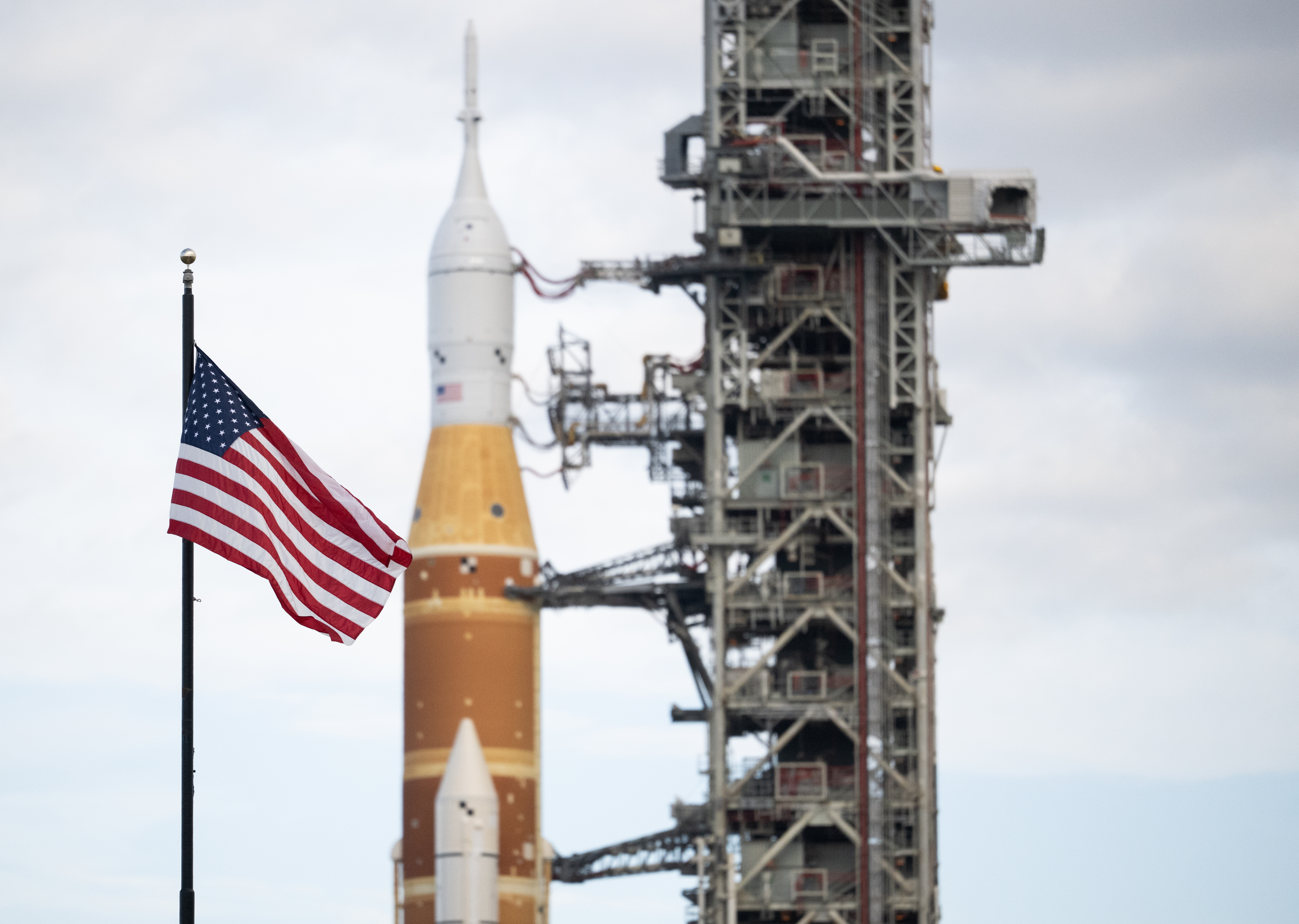
NASA’s Newest Wind Tunnel Opens at NASA Langley
2026-07-31 20:19
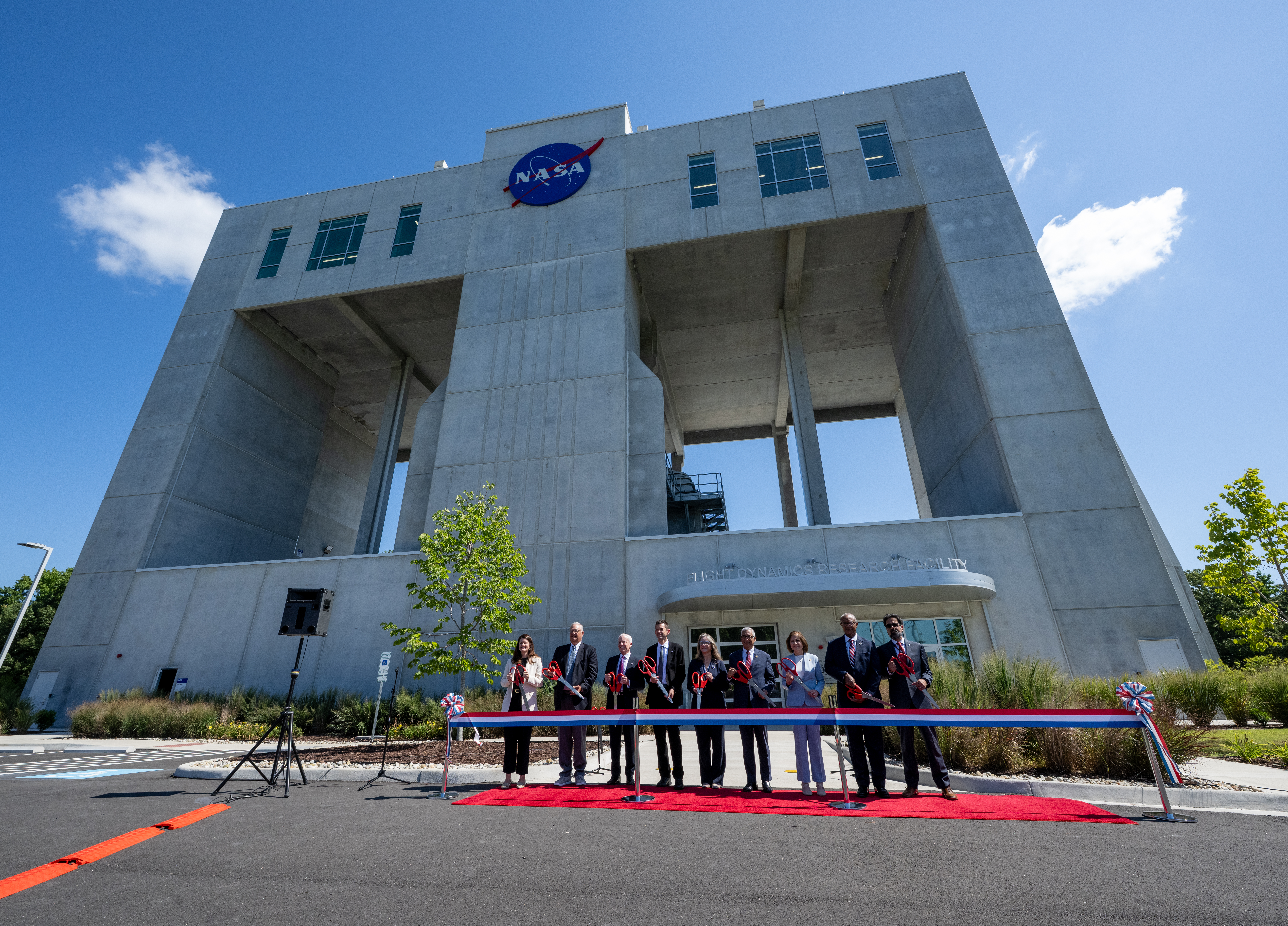
On Friday, July 31, 2026, NASA leadership and Virginia government officials opened NASA’s first major new wind tunnel in more than 40 years, the Flight Dynamics Research Facility at NASA’s Langley Research Center in Hampton, Virginia.
The state-of-the-art facility will support research and technology development that will advance the agency’s aeronautics, exploration, and science goals, including establishing a sustained human presence on the lunar surface through the Artemis program and the development of a Moon Base.
See more photos from the ribbon-cutting ceremony.
Image credit: NASA/Keegan Barber
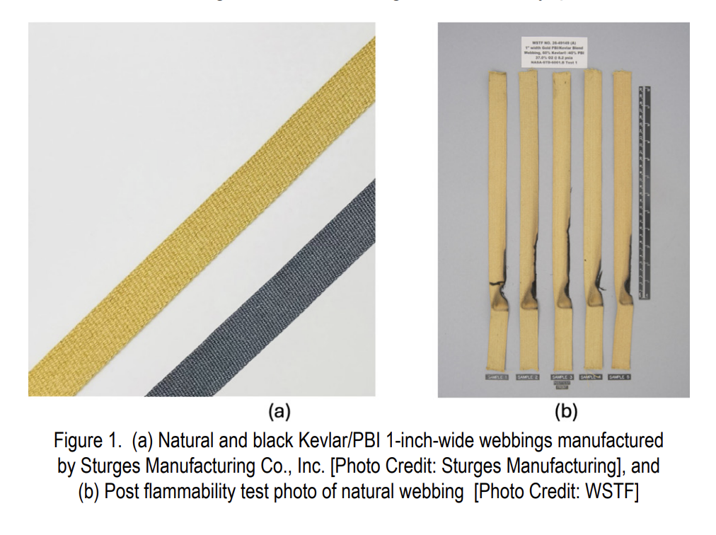
TB 26-04 Webbings for Use in Elevated Oxygen Environments
2026-07-31 19:05
Flammability test results for commercial-off-the-shelf webbings that meet NASA flammability requirements are reported for use in elevated oxygen environments anticipated for future lunar and Martian missions. Testing demonstrated that a webbing composed of 60% Kevlar®/40% polybenzimidazole (PBI) from Sturges Manufacturing Company, Inc., specifically the natural version, passed flammability testing per NASA-STD-6001B Test 1 using a surface ignition in J-configuration at 37% oxygen and 8.2 psia. Offgassing data are also provided for the natural webbing, which is gold colored. These findings support their potential use as suitable webbings
for softgoods applications, although final performance and wear characteristics must be validated in full configuration.
Background
An elevated oxygen environment is planned for future crewed missions to the Moon and Mars to reduce the prebreathe time before extravehicular activities. In this study, materials are being evaluated for use at 37% oxygen and 8.2 psia. An enriched oxygen environment increases the flammability risk and the need for improved fire-resistant materials. The NASA Engineering and Safety Center (NESC) developed a strategy to ensure textile materials that meet NASA flammability requirements in this environment are available to the aerospace community as the building blocks to softgoods flight hardware. The strategy is being implemented by the Mars Campaign Office and Johnson Space Center with support from the NESC. The first phase is testing commercial-off-the-shelf (COTS) textiles with high potential to meet flammability requirements.
Problem/Issue Description
Narrow woven fabrics, commonly referred to as webbing or woven tape, are used in multiple softgood applications, including crew mobility aids, restraint nets, and storage bag handles. The standard meta-aramid or nylon webbings do not meet the flammability requirements in elevated oxygen.
Test Methods/Data Collection
NASA-STD-6001B Test 1 was performed on the webbing candidates at White Sands Test Facility (WSTF) to determine the maximum oxygen concentration (MOC) at a pressure of 8.2 psia. The test was performed in an unshielded J configuration, where the cut edge of the webbing was not exposed to the flame and the igniter impinged on the front surface of the material, which included the lateral free edge of the webbing. Flammability performance after wear and tear was not assessed. The MOC test refers to the maximum oxygen concentration at which a minimum of five samples tested pass the NASA-STD-6001B criteria at a fixed pressure. One-inch-width natural and black webbings, composed of 60% Kevlar and 40% PBI produced by Sturges Manufacturing (see Figure 1), were tested. The available webbing widths range from ¼ to 8 inches.
Analysis and Results
Table 1 summarizes the webbing properties and test results. The webbings had MOCs of 37% and 35% oxygen for the natural and black webbing, respectively, at 8.2 psia. In addition, offgas testing was performed on natural webbing per NASA-STD-6001B Test Detailed test results can be found in MAPTIS links listed in the reference section.
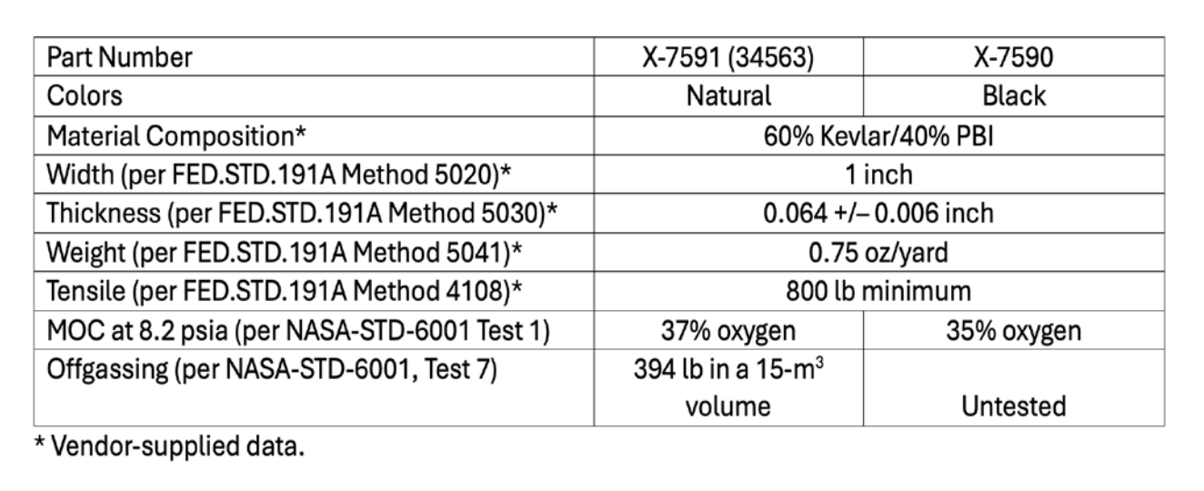
These results should be used to select materials for incorporation into a final softgood product. The final flammability result will depend on the other components of the end item and must be tested in configuration to ensure the final product meets requirements. Individual textile results do not guarantee the performance of the finished assembly. Variations on this webbing (i.e., including but not limited to dimensions, weave type and yarn size, density, treatments, color, fiber blend, edge finish technique, the addition of features like hook and loop fasteners, and wear and tear) may affect flammability characteristics and should be evaluated before use.
References
- Black color webbing: Flammability Report WSTF 26-49145,
https://maptis.ndc.nasa.gov/matsel/app/material/73441?sender=global-search - Natural color webbing: Flammability and Offgassing Report WSTF 26-49149,
https://maptis.ndc.nasa.gov/matsel/app/material/73442?sender=global-search - HEO-DM-1006 Updated Exploration Atmospheres
- Manufacturer website: https://www.sturgesmfgco.com/
- Manufacturer contact: Mike Allen (mallen@sturgesmfgco.com 315-880-0937)
- NASA-STD-6001B Flammability, Offgassing, and Compatibility Requirements
and Test Procedures
TechCrunch - Latest
OpenAI reportedly finds evidence that more of its agents ran amok
2026-07-31 22:47
Rivian spinoff Also to start delivering e-bikes after months of delays
2026-07-31 22:00
Silicon Valley loves young founders. Until it doesn’t.
2026-07-31 22:00
India is starting to pay for apps, not just download them
2026-07-31 21:07
Google nixes its Earth AI feature one day after launch, amid criticism it would spread misinformation
2026-07-31 19:47