📰 Trending Topics
Google News - Trending
Austin Reaves Trending Toward Game 5 Return? - hoopsrumors.com
2026-04-28 13:43
Google News - Technology
YouTube's Picture-In-Picture Mode Is Rolling Out To All Users Worldwide - Engadget
2026-04-30 09:00
- YouTube's Picture-In-Picture Mode Is Rolling Out To All Users Worldwide Engadget
- YouTube starts rolling out free picture-in-picture (PiP) globally on Android, iOS 9to5Google
- YouTube Bringing Free Picture-in-Picture to iPhone Users Outside the U.S. MacRumors
- YouTube Gives Everyone One of Its Best Features for Free Droid Life
- YouTube wants to stay on your screen — even when you leave the app Gulf News
Motorola has a 200MP camera-packing Moto G87 and a glorious new Signature color in the pipeline - PhoneArena
2026-04-29 07:43
- Motorola has a 200MP camera-packing Moto G87 and a glorious new Signature color in the pipeline PhoneArena
- Motorola’s best moto g camera yet arrives with the new moto g87 Motorola News
- Motorola Moto G47 announced with a 108MP camera and a 120Hz screen - GSMArena.com news GSMArena.com
- Moto G87 Tipped to Feature 200-Megapixel Camera; Leaked Renders Hint at Familiar Design Again Gadgets 360
- Motorola debuts high-end Edge Pro 70 and mid-range Moto G87 handsets Telecompaper
Apple Has Likely Abandoned 'iPad Ultra' Plans - MacRumors
2026-04-29 17:30
Samsung might finally redesign Galaxy S phones, unless RAMageddon ruins it - 9to5Google
2026-04-28 17:55
- Samsung might finally redesign Galaxy S phones, unless RAMageddon ruins it 9to5Google
- Samsung Galaxy S27 Camera Redesign Tipped to Enable Native Qi2 Gadget Hacks
- Galaxy S27 Ultra may not feature a 3x telephoto camera SamMobile
- The Samsung Galaxy S27 series could look radically different, with a redesigned rear panel that leaves space for magnets — here's what that might look like TechRadar
- 'Finally something different': Leaker teases Samsung Galaxy S27 Ultra concept with a new camera bar design Tom's Guide
NASA - Breaking News
Winter’s End Is Written in the Clouds
2026-04-30 04:00

Winter 2026 roared to an end in southern Alaska as parts of the coast saw below-normal temperatures and bouts of moderate to heavy snow. Viewed from above, the region’s atmospheric instability was apparent in the striking display of cloud formations just offshore.
A NASA satellite captured this image of the clouds on March 19, 2026, the final day of astronomical winter. According to a NOAA weather briefing, low pressure over the Gulf of Alaska that day combined with high pressure over eastern Russia and northern Alaska, causing cold Arctic air to pour southeast over the Alaska Peninsula.
The setup led to the formation of cloud streets, visible in the middle of the scene, oriented in line with the direction of the wind. These parallel bands can occur when frigid, dry air moves over comparatively warm ocean water and gains moisture. Where the warm, moist air rises, water vapor condenses to form clouds. Where cooled air sinks adjacent to the clouds, skies are clear.
But the transformation does not happen right away; it takes the air mass some time over the sea surface to pick up heat and moisture, which is why the region close to shore is mostly cloud-free. (Note that the hazy area close to shore might be stratus or sea fog.) As the air moves farther over the gulf, the cloud streets continue to mature and change into open-cell clouds—a type of cloud that appears as thin wisps surrounding empty pockets.
Another compelling cloud type is visible toward the bottom-left on the lee side of Unimak Island, the easternmost of the Aleutian Islands. These trails of staggered, counterrotating swirls are von Kármán vortex streets. The cloud patterns can form when winds are diverted around elevated areas, often islands, rising from the ocean.
Finally, an especially striking feature in this scene is the larger cloud vortex about 180 miles (300 kilometers) southwest of Anchorage. According to a post from meteorologist Matthew Cappucci, the feature was a polar low—a small cyclonic formation that forms in cold polar air over relatively warm water. This instance, Cappucci wrote, carried tropical storm-force winds and produced snow and thunderstorms around its center.
Outside of March 19, the month overall brought persistent cold and bouts of storminess to the state. The weather had warmed by the end of April, but news reports indicated more unsettled, wet weather was on the way across Southcentral and Southeast Alaska as an atmospheric river approached the region.
NASA Earth Observatory image by Michala Garrison, using MODIS data from NASA EOSDIS LANCE and GIBS/Worldview. Story by Kathryn Hansen.

References & Resources
- EUMeTrain (2014) Cloud Streets. Accessed April 29, 2026.
- KTUU (2026, April 27) April showers just won’t quit. Accessed April 29, 2026.
- KTUU (2026, April 27) April ends on a wet and breezy note; heavy rain for coastal Southcentral. Accessed April 29, 2026.
- Matthew Cappucci and MyRadar Weather Radar via Facebook (2026, March 19) If you looked at satellite on Wednesday, you probably saw what looked like a tropical storm making landfall in Alaska. Accessed April 29, 2026.
- NWS Alaska Region (2026, March 19) March 19, 2026 – Marine Weather. Accessed April 29, 2026.
- NWS Anchorage (2026, March 19) March 19, 2026 Alaska Weather Daily Briefing. Accessed April 29, 2026.
- University of Alaska Fairbanks (2026, April 21) Alaska climate report: March 2026 saw dangerous weather. Accessed April 29, 2026.
You may also be interested in:
Stay up-to-date with the latest content from NASA as we explore the universe and discover more about our home planet.

A blanket of snow spanned Michigan and much of the Great Lakes region following a potent cold snap.

A collection of fish-shaped clouds hovered above the glacial lake in Patagonia in December 2025.

Following a significant winter storm, frigid temperatures lingered in late January 2026 across a vast swath of the U.S.


I Am Artemis: Ryan Schulte
2026-04-29 21:45
I Am Artemis: Ryan Schulte

Listen to this audio excerpt from Ryan Schulte, Orion flywheel project manager:
0:00 / 0:00
As the four Artemis II astronauts traveled on a 694,481-mile journey around the Moon and back, the Orion spacecraft provided them with all the essentials for deep space life, including daily exercise. The crew used an exercise device called the flywheel throughout their mission to maintain their physical and mental health, and Ryan Schulte, Orion flywheel project manager, led the team responsible for developing the flywheel for the historic flight.
At NASA’s Johnson Space Center in Houston, Schulte oversees the team that designed, built, tested, and flew the flywheel used on Artemis II, and currently develops a fleet of more reusable exercise devices for future Artemis missions.
What we’re doing with this exercise device has a direct impact on the crew’s safety, health, and their mission success. I feel lucky to work on hardware that the crew is physically using, interacting with, and benefiting from on a daily basis.

Ryan Schulte
Orion Flywheel Project Manager
The flywheel is a compact, multi-functional device about the size of a large shoebox that provides the crew with a range of aerobic and resistive workouts without requiring any electrical power from the spacecraft.
“It works kind of like an inertial yo-yo,” said Schulte.
The user can select different gear ratios for different resistance modes, and the flywheel can provide ultimately up to 500 pounds of resistance.
“It’s really all dependent upon how much effort you put in. The crew can do squats, deadlifts, bent rows, high-pulls, curls, heel raises, and aerobic rowing all in one device.”
Developing the flywheel for Orion posed unique challenges for Schulte’s team, ranging from limited space and crew mobility to reducing noise generation for easy crew communication during workouts.
“One of the biggest challenges was trying to fit everything into this compact box, and also to be able to have enough space inside the rest of the capsule for someone to fully stand up and fully extend at high rates of speed and repetitions,” said Schulte.
The team’s successful response to these challenges was displayed during the approximately 10-day Artemis II mission, where the crew members exercised for roughly 30 minutes per day with the flywheel. The sessions helped to counteract both the physical and mental effects induced by a microgravity environment, which on future, longer-duration Artemis missions, will become an increasingly important component for astronauts.

“Without Earth’s gravity, the crew’s muscles, bones, and stamina all begin to atrophy, or weaken,” Schulte said. “Exercise will help prevent injury as crews need to perform long lunar spacewalks on the surface or for emergency egress out of the capsule.”
Exercise with the flywheel also supports the crew’s mental health, providing psychological benefits while living in a compact space inside Orion.
“It’s a great form of stress relief,” Schulte said. “It improves their mental clarity by getting their fluids and their blood flowing, which can stagnate in your head in zero gravity. We’ve talked to some of the crew about how much clearer their minds feel after exercise in flight.”
Schulte began his career as a co-op at Johnson in 2007, then joined NASA full-time as a test engineer for pyrotechnics, propulsion, and power systems. He later transitioned to NASA’s Human Health and Performance Directorate and began working in the Human Research Program, where his interest in human interfaces with engineering grew, eventually leading him to his current role as the flywheel project manager.
With the success of Artemis II and the promise of future missions ahead, Schulte’s work on the flywheel and next generation exercise devices will play a vital role in keeping astronauts safe, healthy, and mission ready on the lunar surface and beyond.
I feel incredibly lucky to be doing what I get to do. There’s not a lot of people out there that get to do this type of work. It is really just an honor and a privilege to be able to serve my country in this way.
Ryan Schulte
Orion Flywheel Project Manager
About the Author
Penelope Lauren Garcia-Galan
Share
Details
Related Terms
Explore More


US-Indian Spacecraft Captures Mexico City Subsidence
2026-04-29 21:12
US-Indian Spacecraft Captures Mexico City Subsidence

NASA/JPL-Caltech/David Bekaert
Description
A scientist produced this map of land subsidence (sinking) in Mexico City using data from the NISAR (NASA-ISRO Synthetic Aperture Radar) mission captured between Oct. 25, 2025, and Jan. 17, 2026. The region has been a well-known hot spot of subsidence for decades, and images like this help confirm that NISAR is performing as expected in its first year of operation.
The dark blue color indicates areas found to be subsiding by more than half an inch (more than 2 centimeters) per month, due in large part to groundwater pumping, which has led to compaction of the dry, ancient lakebed on which the city was built. The yellow and red areas are likely residual noise signals that are expected to decrease as NISAR collects more data and refines its measurements.
Two marshy ecosystems with ties to the country’s past can be seen in the image. The dark green oblong to the northeast of the airport is Nabor Carrillo, an artificial lake constructed over the now-extinct Lake Texcoco. Chalco Lake, a wetland located in a historically fertile region to the south, shares its name with a major body of water that was drained over a period of centuries to reduce flooding in the city. The ancient lake was a primary natural habitat of the Mexican Axolotl, an endangered species of salamander with the ability to regrow limbs.
Another landmark pinpointed in the image — the Angel of Independence along the Paseo de la Reforma — was built in 1910 to commemorate 100 years of Mexico’s independence. Standing over 100 feet (30 meters) tall, the monument has had 14 steps added to its base over the years as the land around it has gradually sunk.

Figure A is a version of the image extending further south and with no labels, scale, or compass.
The images were created with data from NISAR’s L-band radar instrument, which uses a 9-inch (24-centimeter) wavelength that enables its signal to penetrate dense vegetation such as forest canopies.
The satellite’s S-band radar, provided by the Indian Space Research Organisation’s Space Applications Centre, uses a 4-inch (10-centimeter) microwave signal that’s more sensitive to small vegetation, which makes it effective at monitoring certain types of agriculture and grassland ecosystems. Launched in 2025, NISAR is the first satellite to carry two SAR instruments at different wavelengths.
Data from NISAR will benefit humanity by helping researchers around the world better understand changes across our planet’s surface, from cities to forests and glaciers. The global and rapid coverage from NISAR will also provide unprecedented support for disaster response, producing data to assist in mitigating and assessing damage, with observations before and after catastrophic events available in short time frames.
Find more information about NISAR here: https://science.nasa.gov/mission/nisar/


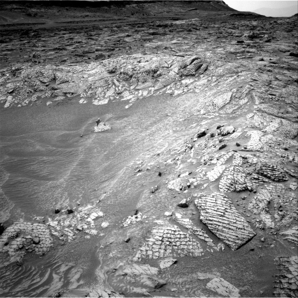
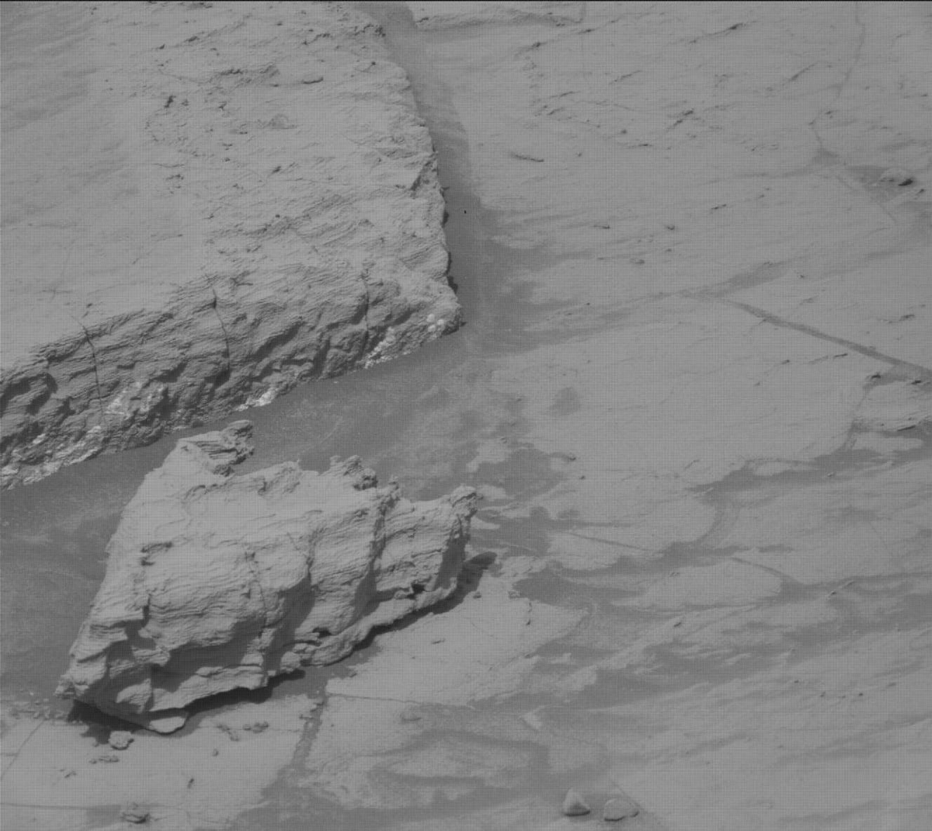
Curiosity Blog, Sols 4873-4878: Welcome to the Atacama Drill Target
2026-04-29 20:38
2 min read
Curiosity Blog, Sols 4873-4878: Welcome to the Atacama Drill Target

Written by Sharon Wilson Purdy, Planetary Geologist at the Smithsonian National Air and Space Museum
Earth planning date: Friday, April 24, 2026
There was excitement in the air as the Curiosity Science Team kicked off a drill campaign at the Atacama site to characterize the first Mount Sharp layered-sulfate bedrock since leaving the boxwork terrain.
Monday was a three-sol plan (4873-4875) where we focused on “drill sol 1” activities that included a pre-load test on our drill target as well as triage contact science. APXS assembled a set of repeated observations on the Atacama drill target, and the coordinated MAHLI images taken with different lighting will provide an opportunity to detect possible changes between the datasets. Mastcam assembled stereo mosaics to document the Atacama drill site, investigate variations in the bedrock at “Kimsa Chata,” and characterize the layering within Paniri butte.
Planning resumed Friday with another three-sol plan (4876-4878) that included the full drill and portion characterization related to “drill sols 2 and 3” activities. Mastcam planned stereo mosaics of rocks in the workspace including a laminated rock with an exposed edge named “Queen of the Andes,” a rock with polygonal fractures that was broken when the rover drove over it named “Curaco,” and more coverage of the “El Almendrillo” target.
Rounding out the plans this week, the Environmental theme group continues to monitor dust in the atmosphere, study cloud movements, and document the presence of dust devils. The rover will also autonomously select two targets to be analyzed by the ChemCam instrument.
Next week we look forward to continuing our drill campaign, where the next step will be delivering a portion of the Atacama target to the ChemMin instrument for analysis. The science team is looking forward to seeing how the mineralogy of the layered sulfate unit here compares to our last drill of the same unit at the Mineral King site, which is nearly 160 meters (525 feet) below our current location!

Share
Details
Related Terms
Explore More


US-Indian Space Mission Maps Extreme Subsidence in Mexico City
2026-04-29 20:23

One of the most powerful radar systems ever launched into space has mapped the ground moving beneath one of fastest subsiding capitals in the world: Mexico City. The findings show how quickly and reliably the NISAR (NASA-ISRO Synthetic Aperture Radar) satellite can track real-time changes across Earth’s surface from orbit, unhindered by clouds or vegetation that impede optical sensors and higher-frequency radars.
Home to some 20 million people, the Mexico City area is built atop an aquifer. Extensive groundwater pumping, combined with the weight of urban development, has resulted in the compaction of the ancient lakebed beneath the city for more than a century. An engineer first documented the issue in 1925, and by the 1990s and 2000s, parts of the metropolitan area were sinking by around 14 inches (35 centimeters) per year, damaging infrastructure including the Metro, one of the largest rapid transit systems in the Americas.
Several generations of space-based radar have tracked Mexico City on the move. The NISAR mission, launched in July 2025, is now advancing these efforts, analyzing fast-changing areas that are challenging to survey from space. Capable of working day and night, rain or shine, NISAR’s L-band synthetic aperture radar is designed to track subtle motions such as land sinking and rising, glaciers sliding, and croplands growing, as it passes overhead multiple times a month.
“Images like this confirm that NISAR’s measurements align with expectations,” said Craig Ferguson, deputy project manager at NASA Headquarters in Washington. “NISAR’s long wavelength L-band radar will make it possible to detect and track land subsidence in more challenging and densely vegetated regions such as coastal communities where they may have the compounding effects of both land subsidence and sea level rise.”
The new analysis is based on preliminary measurements taken by NISAR between October 2025 and January 2026, during Mexico City’s dry season. Parts of the region found to be subsiding by more than half an inch (more than 2 centimeters) per month are shown in dark blue. The yellow and red areas are likely residual noise signals that are expected to decrease as NISAR collects more data. The structure near the center of the image is Benito Juarez International Airport, with Lake Nabor Carrillo visible as a dark green oblong to the northeast.
One area landmark — the Angel of Independence along the Paseo de la Reforma — is a visible indicator of subsidence. Built in 1910 to commemorate 100 years of Mexico’s independence, the towering monument stands 114 feet (36 meters) high and has had 14 steps added to its base as the land around it gradually sinks.
“Mexico City is a well-known hot spot when it comes to subsidence, and images like this are just the beginning for NISAR,” said David Bekaert, a project manager at the Flemish Institute for Technological Research and a member of the NISAR science team. “We’re going to see an influx of new discoveries from all over the world, given the unique sensing capabilities of NISAR and its consistent global coverage.”
A joint mission developed by NASA and the Indian Space Research Organisation (ISRO), NISAR launched from Satish Dhawan Space Centre on India’s southeastern coast. Managed by Caltech, NASA’s Jet Propulsion Laboratory in Southern California leads the United States component of the project and provided the satellite’s L-band SAR and antenna reflector. The spacecraft bus and its S-band SAR were provided by ISRO.
The NISAR satellite is the first to carry two SAR instruments at different wavelengths and is monitoring Earth’s land and ice surfaces twice every 12 days, collecting data using the spacecraft’s giant drum-shaped reflector, which measures 39 feet (12 meters) wide — the largest radar antenna reflector NASA has ever sent into space.
To learn more about NISAR, visit:
https://science.nasa.gov/mission/nisar/
Media Contacts
Andrew Wang / Andrew Good
Jet Propulsion Laboratory, Pasadena, Calif.
626-379-6874 / 818-393-2433
andrew.wang@jpl.nasa.gov / andrew.c.good@jpl.nasa.gov
Written by Sally Younger
2026-027
Explore More


TechCrunch - Latest
Meta says its business AI now facilitates 10 million conversations a week
2026-04-30 12:08
Instagram cracks down on content aggregators
2026-04-30 12:00
SoftBank is creating a robotics company that builds data centers — and already eyeing a $100B IPO
2026-04-30 03:58
Amazon, Meta join fight to end Google Pay, PhonePe dominance in India
2026-04-30 01:00
Amazon’s cloud business is surging — and so is its capital spending
2026-04-30 00:14