📰 Trending Topics
Google News - Trending
Google News - Technology
Apple Releases iOS 26.6 and iPadOS 26.6 With iOS 27 Optimizations - MacRumors
2026-07-27 17:27
- Apple Releases iOS 26.6 and iPadOS 26.6 With iOS 27 Optimizations MacRumors
- iOS 26.6 fixes over 75 security issues with your iPhone, update now 9to5Mac
- Apple rolls out watchOS 26.6 update for Apple Watch AppleInsider
- iOS 26.6 Update Now Available With 3 New Features bgr.com
- iOS 26.6 Release: Next iPhone Update Is Almost Here, Here’s The Target Date Forbes
Tons of Peoples’ Claude Chats and Creations are Exposed on Google - 404 Media
2026-07-27 13:51
- Tons of Peoples’ Claude Chats and Creations are Exposed on Google 404 Media
- A Whole Bunch of People's Claude Chats Are Publicly Accessible Online, and There's Some Wildly Private Stuff in There Futurism
- Claude AI shared chats indexed by Google - see if your conversations were exposed ZDNET
- Uh-oh: Some Claude shared conversations and Artifacts appear to be indexed and publicly accessible on Google Search VentureBeat
- People Found Crypto Wallet Data in Claude Chats Indexed by Google Yahoo Tech
Framework Laptop 13 Pro review: Much better battery, much worse price - Ars Technica
2026-07-27 15:02
- Framework Laptop 13 Pro review: Much better battery, much worse price Ars Technica
- This is oh-so close to my perfect MacBook Pro alternative — then RAMageddon struck The Verge
- Framework says current memory prices are 'far beyond anything we're able to absorb' TweakTown
- Framework Laptop 13 Pro: Aiming To Be One Of The Best Upgradeable Linux Laptops Review Phoronix
- Framework’s Laptop 13 Pro Is Arriving With Less RAM Than Customers Ordered Gadget Review
Apple is reportedly worried about smart glasses, too - Yahoo Tech
2026-07-27 13:57
- Apple is reportedly worried about smart glasses, too Yahoo Tech
- Apple’s Smart Glasses Will Need to Overcome Meta’s Privacy Reputation Bloomberg.com
- Can Apple make smart glasses that aren’t a constant privacy threat? TechCrunch
- Apple is banking on privacy to set its smart glasses apart The Verge
- Apple Is Reportedly Worried About Its Non-Creepy Reputation as It Prepares to Enter a Creepy Product Category Gizmodo
NASA - Breaking News
NASA Science Soars During August Total Solar Eclipse
2026-07-27 18:01
5 min read
NASA Science Soars During August Total Solar Eclipse
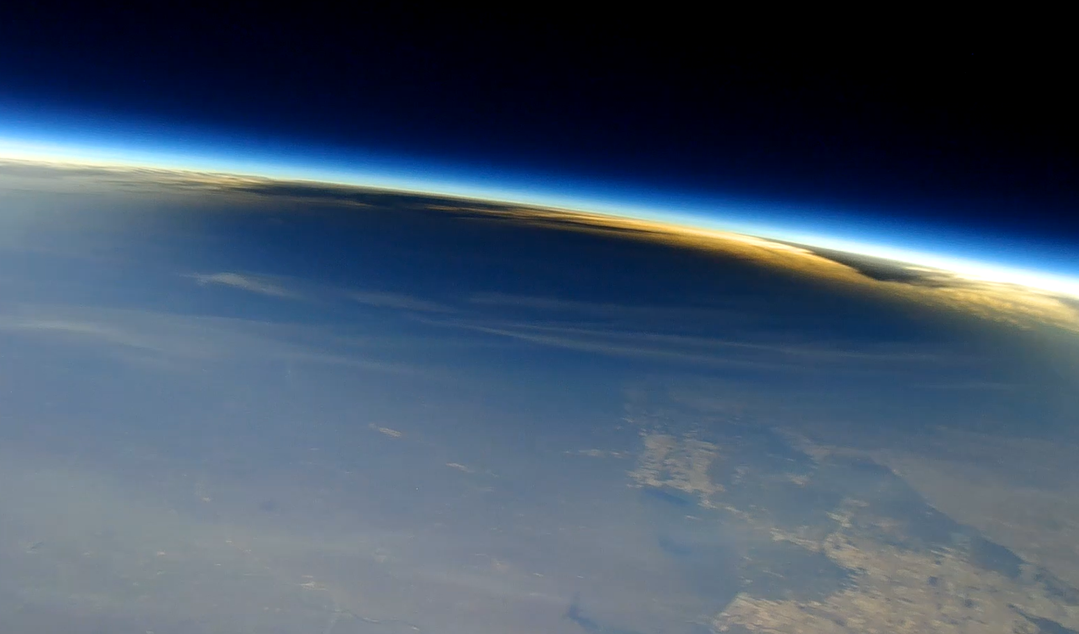
Each time the Moon covers the Sun during a total solar eclipse — darkening daytime skies and briefly revealing the Sun’s ethereal outer atmosphere, the corona — it presents new opportunities to better understand our star and its influence on Earth.
On Wednesday, Aug. 12, as the next total solar eclipse sweeps over Greenland, Iceland, and Spain, NASA-funded science teams will be chasing the Moon’s shadow with a high-altitude jet and scientific balloons to investigate the Sun’s dynamics and how the temporary darkening of our skies affects our atmosphere.
“From our unique perspective on Earth during a total solar eclipse, scientists can study the Sun’s corona in a way we can’t from anywhere else in the solar system,” said Kelly Korreck, eclipse program manager at NASA Headquarters in Washington. “The Sun impacts our daily life, satellites, and astronauts in space, and we can take advantage of this moment to advance our understanding of that influence.”
High-flying jet to record solar dynamics
Soaring in the nose cone of NASA’s WB-57 high-altitude research aircraft is a suite of four cameras to take high-resolution images of the corona in several different wavelengths of visible and infrared light. Part of an instrument developed by the NASA Scientifically Calibrated In-Flight Imagery (SCIFLI) team at NASA’s Langley Research Center in Hampton, Virginia, the cameras will capture at least 20 images per second, recording structures, outflows, and rapid changes in the corona during the total solar eclipse.
With these images, scientists hope to learn more about the formation of prominences (solar material that gets suspended above the Sun’s surface), better understand the corona and how it gets heated to nearly a million degrees, and investigate how material in the corona and the solar wind are related, which flows out from the Sun across the solar system.

By chasing the Moon’s shadow, the jet will extend how long the cameras can observe the corona. On the ground, the longest anyone will be able to see the corona is two minutes and 18 seconds. But flying along the eclipse path at 460 miles per hour, the jet’s view of the corona will last nearly three minutes.
NASA’s WB-57 will fly at 50,000 feet, above any clouds that might obscure the view of the corona from the ground. The altitude also allows the cameras to observe some infrared wavelengths that get absorbed by the lower atmosphere before reaching the ground, and the corona only has been observed in those wavelengths a few times before.

The instrument, called SCIFLI Multispectral Airborne Imager, or SAMI, also flew on a WB-57 during the total solar eclipse on April 8, 2024, providing valuable imagery and information about the corona. However, the study’s principal investigator, Amir Caspi of the Southwest Research Institute in Boulder, Colorado, says each total solar eclipse provides new opportunities to learn more about the corona.
“The Sun is always changing,” Caspi said. “Every eclipse is different. So we could see things we didn’t see before. And we learn from each eclipse how to better observe the next one.”
Caspi’s team also is making some enhancements for the 2026 campaign based on lessons learned in 2024. For example, the team will adjust exposure times to better capture bright features that were overexposed in 2024 imagery. They will also leverage software developed since 2024 to process and analyze the data sooner than before.
The experiment is funded by NASA’s Heliophysics Low Cost Access to Space Program.
Balloons to watch atmospheric changes
When a total solar eclipse suddenly turns daytime skies dark, our atmosphere changes in ways we don’t yet fully understand.
The NASA-supported Nationwide Eclipse Ballooning Project, led by Angela Des Jardins at Montana State University, is sending students from several U.S. universities to Iceland and Spain to launch scientific balloons before, during, and after the eclipse to better understand those changes.

In Iceland, two teams will launch a total of 80 balloons starting 18 hours before the eclipse until eight hours afterward to study how the eclipse affects Earth’s “boundary layer,” the part of the atmosphere that touches the ground. The thickness of the boundary layer changes depending on factors such as surface temperature and moisture in the air.
Previous balloon flights during solar eclipses in October 2023 and April 2024 showed that the boundary layer collapsed, or decreased in thickness, in locations with clear skies but not where there were cloudy skies. Scientists wonder whether that will be different in Iceland in 2026. Changes in the boundary layer are driven by the day-night cycle. However, in Iceland in August, the days are long and nights are short, so the nighttime influences might not be as strong as in 2023 or 2024.
“Will this eclipse be able to collapse the boundary layer?” said Matthew Bernards, a chemical engineering professor at the University of Idaho, who leads one of the Iceland teams.
In Spain, three balloon teams will launch a total of six balloons with 360-degree cameras to image the eclipse shadow from above. These balloons also will include instruments designed to measure levels of ozone in the atmosphere, which requires sunlight to form. Similar balloon experiments showed that ozone decreased during totality in April 2024. Scientists wonder whether there will be differences with this eclipse, particularly since it happens at a later time of day and during a different season.
Follow along
While the total solar eclipse won’t be visible in the U.S., some parts of the country will be able to see a partial solar eclipse. Learn more about where to see the eclipse and how to view it safely.
by Vanessa Thomas
NASA’s Goddard Space Flight Center, Greenbelt, Md.
Share
Details
Related Terms
Explore More


NASA Astronaut Chris Williams Returns to Earth
2026-07-27 16:48
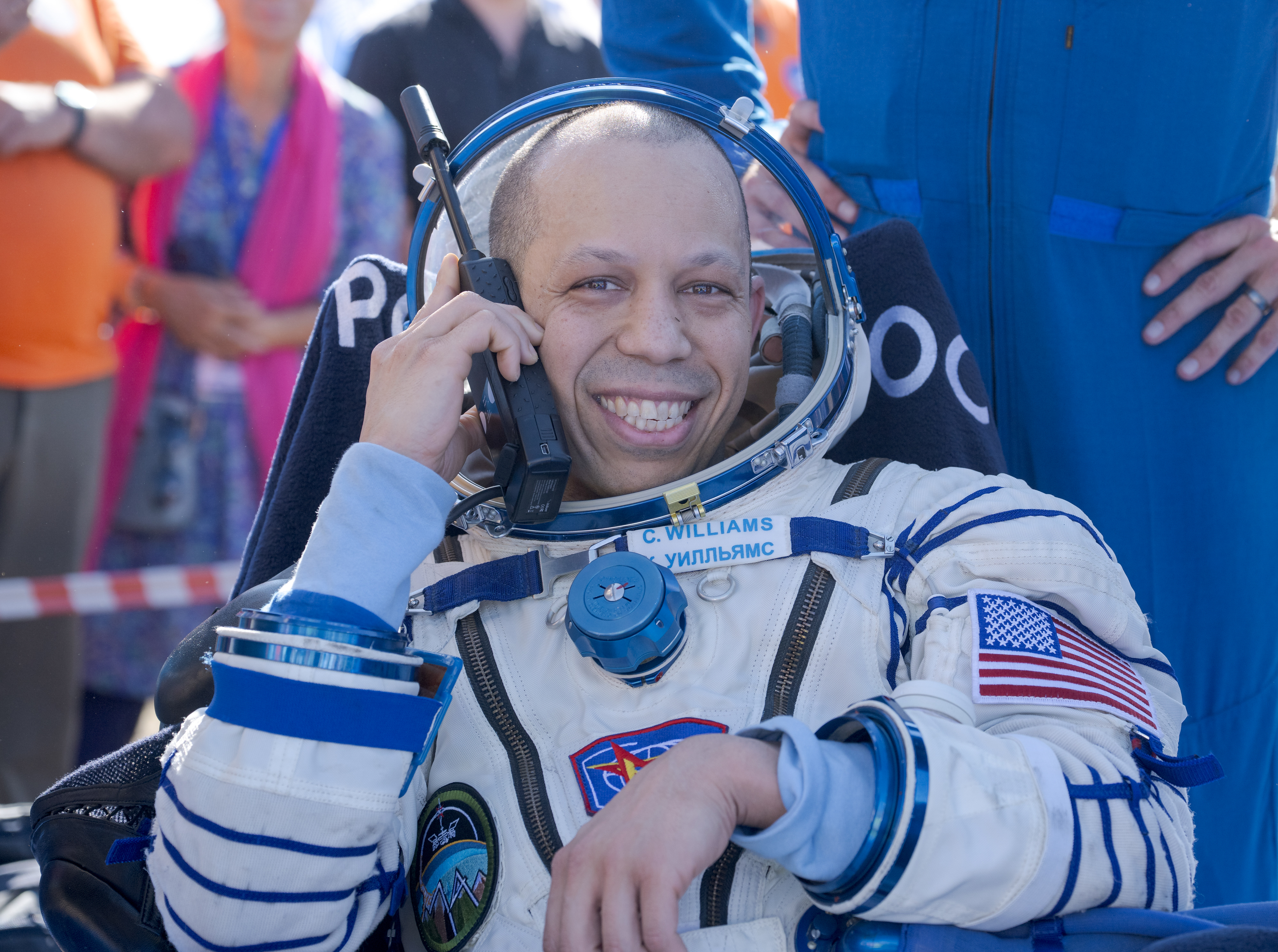
NASA astronaut Chris Williams is all smiles in this July 26, 2026, photo taken shortly after he landed with Expedition 74 Roscosmos cosmonauts Sergey Kud-Sverchkov, and Sergei Mikaev in Kazakhstan. This was Williams’ first mission.
Williams spent eight months aboard the International Space Station, where he supported a wide range of scientific investigations and technology demonstrations. He also completed two spacewalks to prep for space station power system upgrades and to replace a faulty joint on the Canadarm2 robotic arm.
Image credit: NASA/Bill Ingalls
NASA’s Swift Sees ‘Wandering’ Mega Black Hole Shredding Star
2026-07-27 16:06
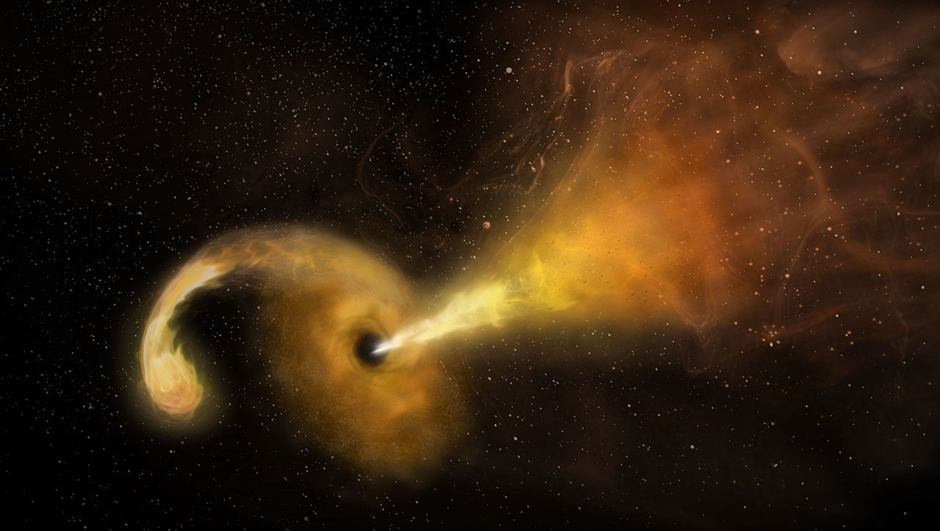
NASA’s Neil Gehrels Swift Observatory captured an “orphan” black hole lighting up as it devoured a star on the outskirts of a faraway galaxy. These phenomena are rare to begin with, and none had ever before been seen so far outside of a galaxy’s core.
“We were looking for these star-shredding events as a way to find otherwise invisible supermassive black holes wandering away from the galactic cores where they usually reside,” said Robert Stein, a research fellow at The University of Maryland, College Park and NASA’s Goddard Space Flight Center in Greenbelt, Maryland. “With this discovery, which is one of just a couple that have been confirmed so far, we’ve validated a new technique and can use it to hunt for more.”
A paper describing the results, led by Stein, was published Monday in The Astrophysical Journal Letters.
Researchers saw an ultrabright flare unleashed by a star being torn apart by extreme gravitational forces after drifting too close to a monster black hole — a phenomenon called a tidal disruption event. The black hole behind the blast weighs in at about a million times the Sun’s mass. Its existence was first flagged in November 2025 as an unusual brightening in a galaxy about 750 million light-years away by ZTF (Zwicky Transient Facility), a survey conducted by the Palomar Observatory in Southern California.
“Out of the half million flashes ZTF detects each night, our new artificial intelligence algorithm automatically recognized a flare that looked a lot like a tidal disruption event, despite its unusual location in the outskirts of a galaxy,” Stein said. For a few months, the tidal disruption event outshone its entire host galaxy in ultraviolet wavelengths, temporarily radiating with the light of about 10 billion suns.
Other telescopes, including the SOAR (Southern Astrophysical Research) telescope in Chile, followed up on the ZTF source to look at the event’s spectrum, which revealed features supporting that it was likely a tidal disruption event. Astronomers then used NASA’s Swift to look at wavelengths they can’t detect with ground-based telescopes to uncover new information. For example, Swift’s UVOT (Ultraviolet/Optical Telescope) took the blip’s temperature and found that it had quite a fever at about 54,000 degrees Fahrenheit (30,000 degrees Celsius).
“The combination of all this data helped us rule out other explanations and confidently say it’s a tidal disruption event, despite its strange location,” said Jonathan Carney, a doctoral student at the University of North Carolina at Chapel Hill, who took the first spectra that supported the flare’s interpretation as a tidal disruption event.
Hidden heavyweights
Nearly every galaxy in the universe is anchored by a supermassive black hole sitting right in the center. About once every 100,000 years, a star will drift too close to this invisible heavyweight and trigger a tidal disruption event.
While they’re rather rare in any given galaxy, scientists scour millions of galaxies for them. Each year, astronomical surveys typically spot about 30 tidal disruption events occurring somewhere in the universe.
Prior to 2024, they’d only been seen in galaxy cores. That’s partly because astronomers mainly looked for them there; after all, it’s where all the known supermassive black holes were, and you can’t get a tidal disruption event without one (the gravitational pull of lighter black holes isn’t strong enough).
Then scientists saw the telltale signs of a star being shredded 2,600 light-years from the center of its host galaxy. That inspired more astronomers to look beyond galaxy cores for similar events, and now a team has identified one more than 30,000 light-years away from a galaxy’s center.
Oddball origin story
So how did the newfound black hole become so off-kilter?
“It must have originated in a galaxy’s center, but not the one it’s in the outskirts of now,” Stein said. “We think the host galaxy’s supermassive black hole is still at its core, but the one eating the star could have started off in a small galaxy that merged with the big one we see today.”
The researchers have outlined two possibilities. Three or more galaxies may have merged together, and the gravitational tug-of-war between their central supermassive black holes may have flung the lightest black hole out to the galaxy’s edge.
Or a dwarf galaxy could be midway through a merger. As the dwarf’s stars fell into the larger galaxy, one may have passed too close to the dwarf’s supermassive black hole.
“Further discoveries could reveal the origin of this apparent ‘orphan’ black hole,” Stein said. “The key science question we want to answer is: How common are wandering black holes?”
The answer may soon be within reach. “Pointed science observations with Swift’s UVOT and XRT (X-Ray Telescope) instruments are temporarily suspended as the mission awaits an orbit boost, which is planned for this summer,” said co-author S. Bradley Cenko, Swift’s principal investigator at NASA Goddard. The spacecraft, whose primary mission ran from 2004 to 2006, is slowly sinking toward Earth due to atmospheric drag after more than 20 years of observations of the changing universe. Nudging it to a higher orbit could extend its lifetime even longer. “Once it resumes normal operations, Swift could continue searching for more examples of out-of-place black holes.”
In the coming years, scientists will use the new technique to search for disintegrating stars in observations from the newly operational Vera C. Rubin Observatory, jointly funded by the U.S. Department of Energy and National Science Foundation, in Chile and NASA’s upcoming Nancy Grace Roman Space Telescope.
“Rubin’s wide, deep surveys will reveal a much larger sample of tidal disruption events than current observatories are capable of collecting, including ones that are off-center,” Carney said. “And Roman’s space-based surveys will extend the current search zone by seeing ones that are farther away, looking back through 9 billion years of cosmic history.” Adding their observations to Swift’s and those from ground-based observatories will bring astronomers closer than ever before to completing a census of the universe’s behemoth black holes.
To learn more about the Swift mission, visit:
By Ashley Balzer
NASA’s Goddard Space Flight Center, Greenbelt, Md.
Media contact:
Claire Andreoli
NASA’s Goddard Space Flight Center, Greenbelt, Md.
301-286-1940
Share
Details
Related Terms
NASA to Cover Three US Spacewalks, Host Preview News Conference
2026-07-27 14:35
NASA will provide coverage as astronauts venture outside the International Space Station during three spacewalks in August to continue upgrading solar arrays, replace a communications antenna, and connect power and data cables in support of space station operations.
Experts will preview the upcoming spacewalks during a news conference at 2 p.m. EDT, Thursday, July 30, from NASA’s Johnson Space Center in Houston.
NASA will stream these events through a variety of platforms. Learn where to watch online:
NASA participants in the news conference include:
- Bill Spetch, deputy manager of Commercial, Low Earth Orbit Program
- Chris Dobbins, spacewalk flight director
- Chloe Mehring, spacewalk flight director
United States-based media interested in attending in person must contact the Johnson newsroom no later than 3 p.m., Wednesday, July 29, at jsccommu@mail.nasa.gov. Media joining by phone should request dial-in details by the same deadline. To ask a question, media must dial in no later than 15 minutes before the start of the news conference.
Thursday, Aug. 6
NASA astronauts Jessica Meir and Anil Menon will exit the Quest airlock to install hardware that will modify the station’s 3B power channel and prepare it for the future installation of an International Space Station Roll-Out Solar Array (IROSA). The solar array, scheduled for delivery later this year, will be the seventh IROSA and will provide additional power to support critical station operations, including its safe and controlled deorbit.
Watch NASA’s live coverage of U.S. spacewalk 96 beginning at 6:30 a.m. The spacewalk is expected to start at 8 a.m. and last about six and a half hours.
This spacewalk will be the sixth for Meir and the first for Menon. Meir will serve as spacewalk crew member 1 and will wear a suit with red stripes. Menon will serve as crew member 2 and will wear an unmarked suit.
Thursday, Aug. 13
During U.S. spacewalk 97, two astronauts will replace a Space-to-Ground antenna on the orbital complex. The antenna is a critical communication system NASA uses to transmit data and high‑speed communication between the Mission Control Center in Houston and the space station.
Tuesday, Aug. 25
The U.S. spacewalk 98 crew members will connect power channel cables and data relay systems as part of ongoing maintenance, including preparations for the space station’s future deorbit. The astronauts also will replace a navigational aid used for spacecraft docking on the Harmony module’s forward port.
NASA will share additional details about U.S. spacewalks 97 and 98, including timing, assigned crew members, and coverage information, closer to each operation.
The spacewalks will be the 281st, 282nd, and 283rd conducted in support of space station assembly, maintenance, and upgrades.
To learn more about International Space Station research, operations, and its crews, visit:
-end-
Joshua Finch / Jimi Russell
Headquarters, Washington
202-358-1100
joshua.a.finch@nasa.gov / james.j.russell@nasa.gov
Sandra Jones / Anna Schneider
Johnson Space Center, Houston
281-483-5111
sandra.p.jones@nasa.gov / anna.c.schneider@nasa.gov
NASA’s Hubble Shows Star Formation in Andromeda Galaxy Winding Down
2026-07-27 14:00
NASA’s Hubble Shows Star Formation in Andromeda Galaxy Winding Down
Image: NASA, ESA, Benjamin Williams (UWashington), Zhuo Chen (UWashington), L. Clifton Johnson (Northwestern); Image Processing: Joseph DePasquale (STScI)
A new study using data from NASA’s Hubble Space Telescope finds that star formation in the nearby Andromeda galaxy has undergone a 500-million-year decline, with an even steeper drop in the last 40 million years. Andromeda, a spiral galaxy comparable in size to our Milky Way, is close enough to be seen with the unaided eye from areas with dark skies. Located about 2.5 million light-years from Earth, practically our cosmic backyard, Andromeda offers an opportunity for astronomers to examine its stellar populations in detail, leading to better understanding of the past of galaxies like our own.
The results published Monday in The Astrophysical Journal.
To reach this conclusion, the researchers combined data from two Hubble surveys: the Panchromatic Hubble Andromeda Treasury and the Panchromatic Hubble Andromeda Southern Treasury. Together, these two surveys mapped two-thirds of the disk of Andromeda in ultra-sharp detail. In total, the team measured about 200 million individual stars across the galaxy, giving them a detailed picture of Andromeda’s past activity.
“We need to measure the individual stars because they are the fossil record of the galaxy’s formation. Hubble is the only telescope that can give you high enough spatial resolution over a large enough area to be able to do that in Andromeda,” said Ben Williams, astronomer at the University of Washington and a co-author on the study.
Massive stars are bluer and short-lived, while less massive stars are redder and longer-lived. As a result, areas that have experienced recent star formation tend to have a larger fraction of blue stars, while areas with less recent star formation typically have a redder population. The team divided the Andromeda images into thousands of squares, spanning 300 light-years on each side of the square, and determined the history of star formation within each parcel to gain a comprehensive view of the galaxy’s past.
Steady decline
Previous research showed the Andromeda galaxy experienced a dramatic burst of star formation about 2 billion years ago, likely due to a past interaction or merger with another galaxy. Since that time, star formation has been steadily declining.
Astronomers measure the rate of star formation in terms of the mass, or amount of gas and dust, converted into stars per year. The researchers calculated that, 500 million years ago, Andromeda formed stars at a rate of about one solar mass per year. However, the formation rate dropped to about half that by 40 million years ago. The current rate has plummeted even farther, to about one-fifth the mass of our Sun per year.
The team also examined whether that decline was consistent across the galaxy or concentrated in certain areas. They found that much of the recent star formation has occurred in a star-forming ring located about 32,000 light-years from the galaxy’s center. As a result, much of the decline they measure is driven by decreasing activity within that ring.
Rather than being the result of reduced material from which new stars can form, the decline is more likely to be a natural winding down from its previous, more active state.
“It’s just like after running a marathon, sometimes you’ve got to take a bit of a breather,” said Tobin Wainer, lead author, University of Washington.
Likely suspect
The team also investigated whether there was any connection between the decrease of activity in Andromeda and its proximity to satellite galaxy M32 (Messier 32). The M32 galaxy is separated from Andromeda by about 16,000 light-years in the plane of the sky; however, its 3D location in space is uncertain. As a result, astronomers are unsure if or when it might have interacted with Andromeda in the past.
“One of the major motivations for this program was to probe potential interactions between M32 and Andromeda’s disk,” said Zhuo Chen, co-author, University of Washington.
Survey data from the Panchromatic Hubble Andromeda Southern Treasury allowed the team to study the history of star formation in Andromeda near M32. They found that this area showed signs of decreased star formation compared with other regions. The timing of this decrease, which this study finds began roughly 60 million years ago, could help constrain when the M32 galaxy interacted with Andromeda’s disk.
“We can’t explicitly say that we are seeing a decrease in star formation because of M32. But it’s right there, and it’s definitely the most likely suspect,” said Wainer.
The team plans to continue analyzing the Hubble data and combine it with data from ground-based observatories to gain additional insights into the history of Andromeda.
“There’s a strong scientific value to this archival data. Andromeda is important because it’s a neighbor that is close enough that we can see it in great detail while also getting a global perspective,” said Raja GuhaThakurta, co-author, University of California Santa Cruz.
An even greater global perspective is likely to come from NASA’s Nancy Grace Roman Space Telescope after it launches as early as Sunday, Aug. 30. Roman’s gigantic field of view can cover at least 100 times as much area as Hubble at near-infrared wavelengths in a single observation. A newly approved Roman observing program will image the entirety of Andromeda’s disk and areas of its surrounding halo, allowing astronomers to measure hundreds of millions of stars and enabling groundbreaking new science.
The Hubble Space Telescope has been operating for more than three decades and continues to make ground-breaking discoveries that shape our fundamental understanding of the universe. Hubble is a project of international cooperation between NASA and ESA (European Space Agency). NASA’s Goddard Space Flight Center in Greenbelt, Maryland, manages the telescope and mission operations. Lockheed Martin Space also supports mission operations at Goddard. The Space Telescope Science Institute in Baltimore, which is operated by the Association of Universities for Research in Astronomy, conducts Hubble science operations for NASA.
Related Images & Videos

Share
Details
Claire Andreoli
NASA’s Goddard Space Flight Center
Greenbelt, Maryland
claire.andreoli@nasa.gov
Christine Pulliam
Space Telescope Science Institute
Baltimore, Maryland
Related Terms
Related Links and Documents
TechCrunch - Latest
Microsoft launches its first cybersecurity model, plus a new agentic cybersecurity system
2026-07-27 18:32
Apple sued after alleged App Store crypto scam cost users $1.8M
2026-07-27 18:28
Amazon’s new satellite network for mobile phones could turn up the heat on SpaceX
2026-07-27 18:08
Antares raises $470M to build nuclear reactors for the US military
2026-07-27 17:49
OpenAI’s Hugging Face breach has reignited the debate over alignment and control
2026-07-27 17:28


