📰 Trending Topics
Google News - Trending
Google News - Technology
Apple’s AirPods with cameras for AI are apparently close to production - The Verge
2026-05-07 19:39
- Apple’s AirPods with cameras for AI are apparently close to production The Verge
- Apple’s Camera-Equipped AirPods Reach Late Testing in AI Device Push Bloomberg.com
- Apple is putting cameras in AirPods. What could possibly go wrong? SoundGuys
- Apple’s Incoming CEO Declares The Company Is “About To Change The World” As The Camera-Equipped AirPods Pro Take Shape Wccftech
- Apple hits milestone in development of AirPods with cameras: report 9to5Mac
Apple May Drop Base $599 MacBook Neo as Chip, DRAM Costs Climb - MacRumors
2026-05-07 11:55
- Apple May Drop Base $599 MacBook Neo as Chip, DRAM Costs Climb MacRumors
- Are the $599 MacBook Neo's Days Numbered? CNET
- Report: Apple kicks off new run of A18 Pro chips as MacBook Neo demand exceeds expectations 9to5Mac
- Apple’s $599 MacBook Neo could be at risk from rising RAM prices The Verge
- MacBook Neo shortages force new A18 Pro run & doubled production to keep up AppleInsider
OpenAI Debuts A Codex Plugin For Chrome - Engadget
2026-05-07 21:57
- OpenAI Debuts A Codex Plugin For Chrome Engadget
- OpenAI's Codex Now Works in Chrome With New Extension MacRumors
- Codex Now Works in Chrome via New Plugin on Windows & macOS Windows Report
- OpenAI Launches Codex Chrome Extension for Browsers Let's Data Science
- OpenAI Codex can now work directly in Chrome on macOS and Windows Neowin
Anthropic introduces "dreaming," a system that lets AI agents learn from their own mistakes - Venturebeat
2026-05-08 00:10
- Anthropic introduces "dreaming," a system that lets AI agents learn from their own mistakes Venturebeat
- Claude Just Gained an "Infinite" Context Window : Here is What It Means for Your Workflows Geeky Gadgets
- Anthropic’s Claude Managed Agents can now “dream,” sort of Ars Technica
- I Am Begging AI Companies to Stop Naming Features After Human Processes WIRED
- Anthropic updates Claude Managed Agents with three new features 9to5Mac
Google’s Screenless Fitbit Air Relies on Gemini to Be Your Personal Health Coach - Gizmodo
2026-05-07 14:00
- Google’s Screenless Fitbit Air Relies on Gemini to Be Your Personal Health Coach Gizmodo
- Introducing the all-new Fitbit Air blog.google
- Google’s plan to win the AI health race? Play nice with Apple and other rivals CNN
- Google Launches $100 Fitbit Air Without a Screen to Rival Whoop Bloomberg.com
- Google's Biggest Health Announcements: New Fitbit Air, Goodbye Fitbit App and Hello 'Coach' CNET
NASA - Breaking News
Tracy Arm’s Post-Tsunami Landscape
2026-05-08 04:00


July 26, 2025
August 19, 2025
Carved over millennia by the pressure and motion of glacial ice, the valley walls cradling the Tracy Arm fjord in southeast Alaska continue to be reshaped. In summer 2025, following the rapid retreat of South Sawyer Glacier, a large landslide sent rock careening into the fjord, altering the wider landscape in a matter of minutes.
The slide culminated on the morning of August 10, 2025, when at least 64 million cubic meters of rock slid downslope. Material entering the fjord induced a tsunami that stripped trees and other vegetation from the opposing fjord wall up to 1,578 feet (481 meters) above sea level. While this peak was the highest “runup” reached by the tsunami, shores and islands down the fjord also saw substantial destruction.
NASA-USGS Landsat satellites captured these images on July 26 (left) and August 19 (right), before and after the event, respectively. “The bright landslide scar on the north side of the fjord is striking, as is the ‘bathtub’ ring around the fjord showing the areas where the forest was leveled by the tsunami,” said Dan Shugar, a geomorphologist at the University of Calgary.
Note that Sawyer Island, about 6 miles (9 kilometers) from the landslide, also turned from green to brown. Only a few trees still stood at the island’s higher elevations.

In the months following the slide, Shugar and colleagues combined satellite, airborne, and ground-based observations with eyewitness reports and simulations to build a more complete picture of how the event unfolded. Their analysis, detailing the event from its lead-up through its aftermath, was published May 6, 2026, in the journal Science.
In addition to the details outlined above, the researchers showed that water continued to slosh around the fjord—a phenomenon known as a “seiche”—for more than a day. Both the landslide and seiche produced seismic signals detected around the world, the former equivalent to a magnitude 5.4 earthquake.
The Landsat images also reveal significant retreat at the front of South Sawyer Glacier in less than a month. “Part of that occurred between the date of the first image and the date of the landslide,” Shugar said. “But part of it is from the landslide itself, which broke off a big chunk of the terminus of South Sawyer Glacier, resulting in a slurry of icebergs in the fjord.”
The exact mechanisms that caused the landslide remain uncertain and could have involved a combination of factors. Rainfall, which was moderate prior to the event, and the rapid retreat of glaciers can both destabilize a slope. What is clear, however, is that the glacier’s retreat exposed a new area of open water, leaving it vulnerable to a landscape-reorganizing tsunami.

No one was injured in the event, though it did catch some by surprise. Kayakers camping on Harbor Island near the fjord’s mouth had their gear swept away, and passengers aboard a small cruise vessel in neighboring Endicott Arm reported swings in water levels and a strong current associated with the tsunami. Brentwood Higman of Ground Truth Alaska, a co-author of the paper, noted that a glacier’s shift from relative stability to renewed retreat, visible in satellite images, could serve as an important indicator that an area has become more susceptible to landslide and tsunami hazards.
NASA Earth Observatory images by Michala Garrison, using Landsat data from the U.S. Geological Survey. Photograph by John Lyons/U.S. Geological Survey. Story by Kathryn Hansen.


References & Resources
- Alaska Public Media (2025, August 12) ‘Pure chaos out of nowhere’: Mega-landslide and tsunami rip through Tracy Arm south of Juneau. Accessed May 7, 2026.
- AP News (2026, April 12) Cruise companies to Alaska are avoiding a popular excursion to Tracy Arm after a massive landslide. Accessed May 7, 2026.
- NASA Earth Observatory (2024, November 12) Sizing Up a Greenland Tsunami. Accessed May 7, 2026.
- Shugar, D. H., et al. (2026) A 481-meter-high landslide-tsunami in a cruise ship–frequented Alaska fjord. Science, 392 (6798).
- University of Alaska Fairbanks (2025, August 12) Tsunami-causing slide was largest in decade, earthquake center finds. Accessed May 7, 2026.
- U.S. Geological Survey (2025, August 13) 2025 Tracy Arm Landslide Before and After Satellite Imagery. Accessed May 7, 2026.
You may also be interested in:
Stay up-to-date with the latest content from NASA as we explore the universe and discover more about our home planet.

Satellite-based radar images show where a powerful earthquake in the Yukon, Canada, sent rock, snow, and ice spilling across the…

Heavy rains from Tropical Cyclone Maila triggered a deadly landslide in the mountains of East New Britain.

Scientists relied on satellite data to understand how the Antarctic glacier lost so much ice so rapidly.


Meet the Fleet: NASA Armstrong Continues Legacy of Flight Research
2026-05-07 23:45
3 min read
Preparations for Next Moonwalk Simulations Underway (and Underwater)
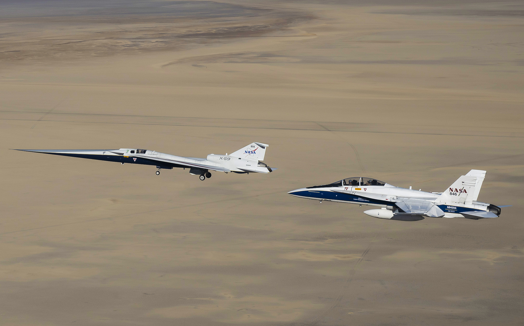
NASA’s home for experimental flight is welcoming more flyers to its already high-performing fleet as it continues to support science and aeronautics test missions – continuing the legacy of pioneers like Neil Armstrong.
NASA’s Armstrong Flight Research Center in Edwards, California, added multiple aircraft this year: two F-15s supersonic jets, a Pilatus PC-12 utility plane, and a T-34 turboprop trainer, which the center will use to support the agency’s advancement of aerospace research.
Throughout the center’s history, pilots have flown everything from large aircraft like the 747 Shuttle Carrier Aircraft and rocket-powered airplanes like the X-15 to high-speed repurposed fighter jets like the F-18. And after almost 80 years, flight research is still going strong in the desert today.
“Armstrong has a rich history of flight research, but it’s the multidimensional skills of the people we have here, and the knowledge they’ve built to handle very unique aircraft maintenance and modifications, that stands out,” said Darren Cole, capabilities manager for the Flight Demonstrations and Capabilities project at NASA Armstrong.
Armstrong has a rich history of flight research, but it’s the multidimensional skills of the people we have here … that stands out.

Darren Cole
Capabilities Manager at NASA Armstrong
The center plays a pivotal role in worldwide airborne science missions, flying scientists and equipment from NASA, other government agencies, industry, and academia to collect measurements such as air pollution levels, glacier melt trends, and wildland fire mapping.
Scientists can manage experiments in real time aboard flying laboratories like the NASA ER-2, to collect important data with the help of Armstrong’s pilots and airborne science team.
“We all come together to make the science happen,” said Matt Berry, airborne research platforms branch chief at NASA Armstrong. “It is the agility of the Armstrong team that allows us to collaborate with scientists, get their equipment onboard, and to fly them to areas where they need to collect data.”
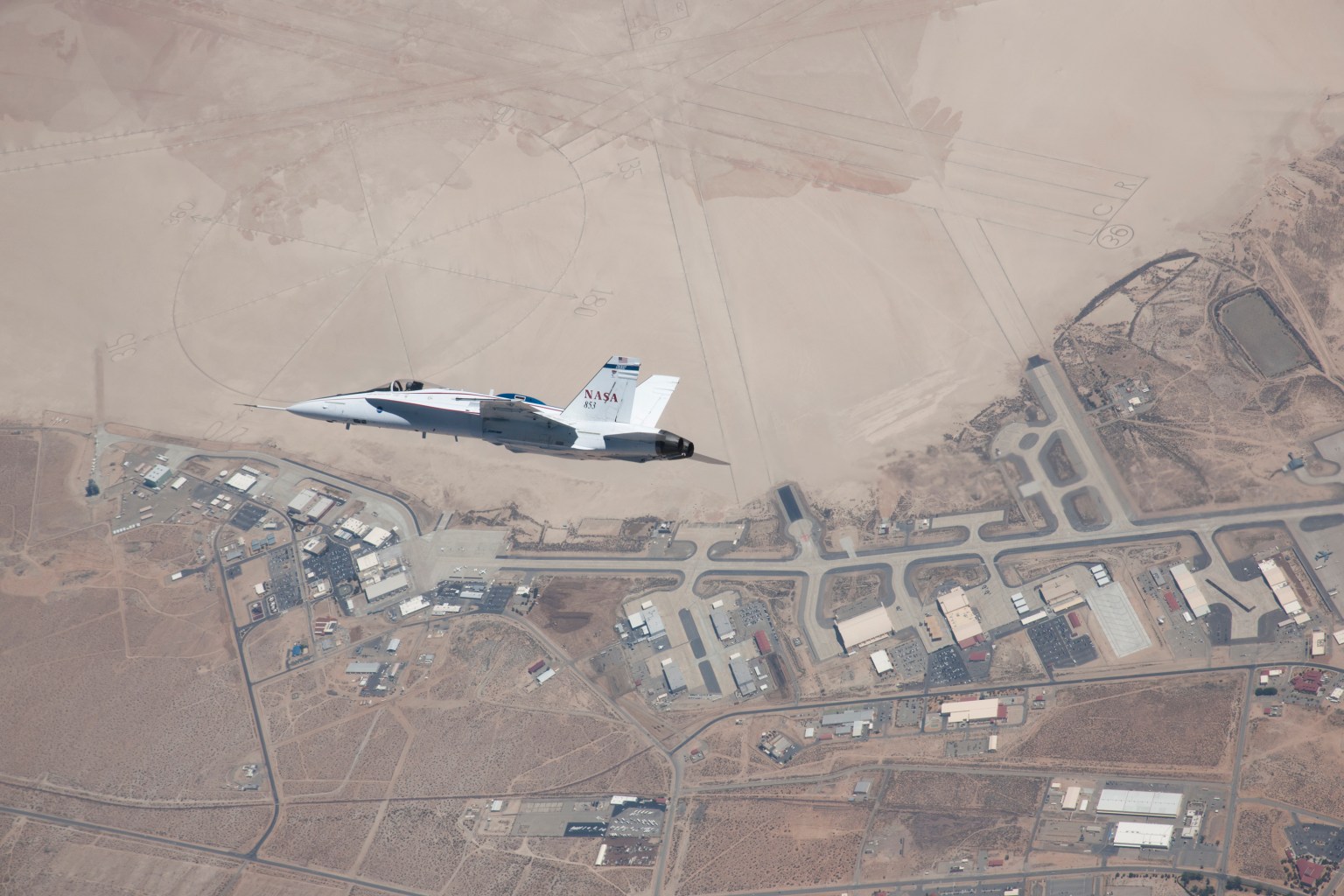
The center sits on Rogers Dry Lake, a 44-square-mile slat flat area used for aviation research and test operations. Rogers and the adjacent Rosamond Dry Lake have seen everything from space shuttle landings to emergency test flight recoveries. The Rogers lakebed continues to serve as an important piece of Armstrong’s test missions.
For NASA Armstrong, it all started with the first attempt by a human to fly faster than the speed of sound in the Bell X-1. In 1946, 13 employees from NASA’s predecessor agency, the National Advisory Committee for Aeronautics (NACA), arrived at what was then known as Muroc Army Airfield to prepare for the X-1 tests. A year later, NACA’s Muroc Flight Test Unit was established as a permanent facility at the airfield.
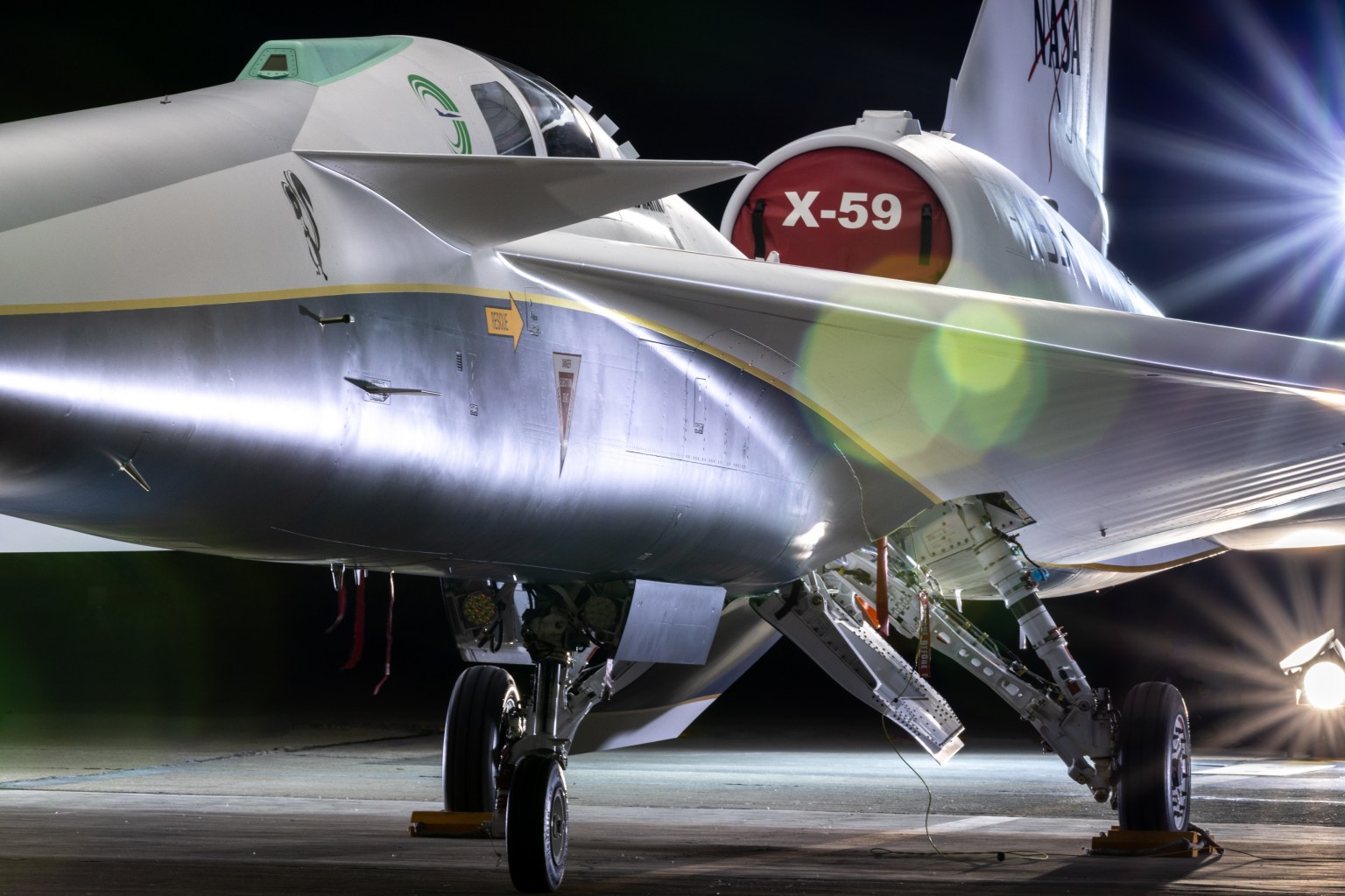
The center has gone by several names over the years, most recently changing from NASA’s Dryden Flight Research Center to NASA Armstrong in 2014. But its legacy has never shifted: The Bell X-1E, the last of the X-1 series of aircraft, now sits in front of NASA Armstrong, welcoming the newest test pilots, engineers, scientists, explorers, and dreamers. And they’re using the aircraft of today to break new barriers.
“I don’t think there is another place in the world with a more diverse fleet of aircraft. We have everything from a low-altitude powered glider to ER-2s, which are flying at high altitudes, and a multitude of aircraft in between,” Cole said.
From sourcing rare components to machining custom parts in-house, NASA Armstrong’s teams transform these aircraft into research workhorses. The center continues its crucial role in leading aeronautics testing, Earth science research, and supporting government and industry partners.
Share
Details
Related Terms
Explore More


NASA Welcomes Paraguay as 67th Artemis Accords Signatory
2026-05-07 20:41

The Republic of Paraguay signed the Artemis Accords on Thursday during a ceremony in Asunción, becoming the latest nation to commit to the shared principles guiding civil space exploration.
“Today, I am proud to welcome Paraguay as the 67th signatory to the Artemis Accords,” said NASA Administrator Jared Isaacman. “They join an ever-growing coalition of like-minded nations committed to the peaceful, transparent, and responsible exploration of space. Established by President Trump in his first term, the Artemis Accords provided the principles for how we explore the Moon, Mars, and beyond. Now, with his national space policy, we are putting the Artemis Accords into practice with our Moon Base. We are creating opportunities for all Artemis Accords signatories, including Paraguay, to join us on the lunar surface and advance our shared objectives in this next era of exploration.”
U.S. Embassy Asunción Chargé d’Affaires ad interim Aaron Pratt shared Isaacman’s remarks during the ceremony. Minister President of the Paraguayan Space Agency Osvaldo Almirón Riveros signed on behalf of Paraguay.
“The signing of the Artemis Accords represents a historic milestone for Paraguay and reflects our commitment to international cooperation, the peaceful use of outer space, scientific development, and the advancement of national space capabilities,” said Almirón Riveros. “This step strengthens Paraguay’s position within the global space community and opens new opportunities for research, innovation, and sustainable development.”
The Paraguayan Space Agency was established in 2014 and has worked to develop capabilities in satellite technology and Earth observation, including with international partners. Its first satellite, GuaraníSat‑1, launched from the International Space Station in 2021. The agency now is preparing to launch its second satellite, GuaraníSat‑2, in October aboard a Falcon 9 from Vandenberg Space Force Base in California. The mission was developed with collaborators from NASA’s Jet Propulsion Laboratory and other partners.
In 2020, the United States, led by NASA and the U.S. State Department, joined with seven other founding nations to establish the Artemis Accords, responding to the growing interest in lunar activities by both governments and private companies. The Artemis Accords introduced the first set of practical principles aimed at enhancing the safety and coordination between like-minded nations as they explore the Moon, Mars, and beyond.
Signing the Artemis Accords means committing to explore peaceably and transparently, to render aid to those in need, to enable access to scientific data that all of humanity can learn from, to ensure activities do not interfere with those of others, and to preserve historically significant sites and artifacts by developing best practices for space exploration for the benefit of all.
More countries are expected to sign the Artemis Accords in the months and years ahead, as NASA continues its work to establish a safe, peaceful, and prosperous future in space.
For more information about the Artemis Accords, visit:
NASA Sends Mars Helicopter Blades Beyond Mach 1
2026-05-07 18:33
NASA Sends Mars Helicopter Blades Beyond Mach 1
NASA/JPL-Caltech
Description
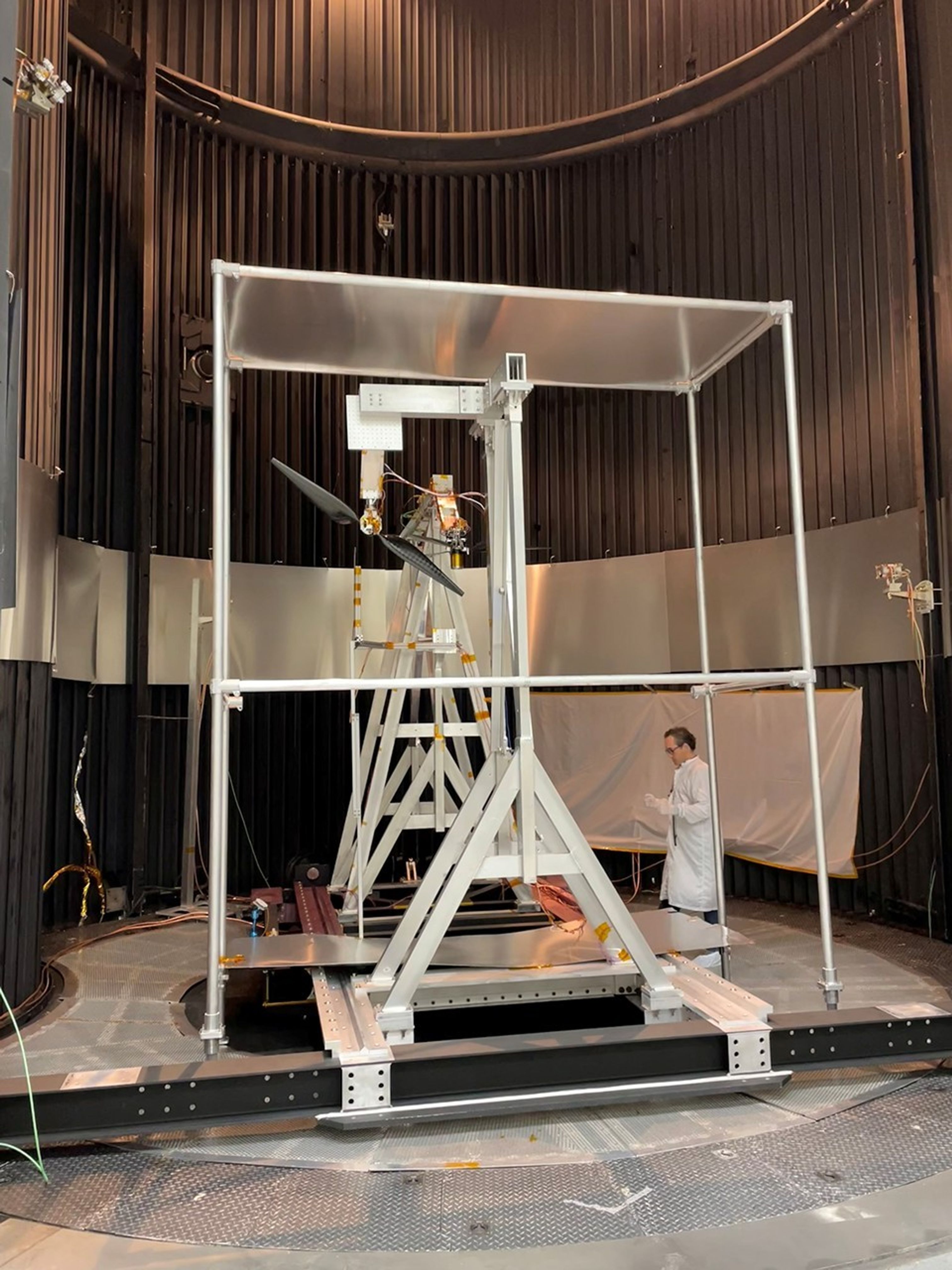
Engineer Fernando Mier-Hicks inspects a test stand used to investigate the performance of next-generation Mars helicopter rotor blades at high speeds inside the 25-Foot Space Simulator at NASA’s Jet Propulsion Laboratory in Southern California in November 2025. Data from the tests indicate that the rotors could surpass the sound barrier without breaking apart.
The test campaign was funded by the agency’s Mars Exploration Program in pursuit of maximizing the capability of future aircraft flying at the Red Planet. A division of Caltech in Pasadena, JPL manages the Mars Exploration Program for NASA’s Science Mission Directorate in Washington.


NASA’s Next-Gen Mars Helicopter Rotors Are Moving Fast
2026-05-07 18:32
NASA’s Next-Gen Mars Helicopter Rotors Are Moving Fast
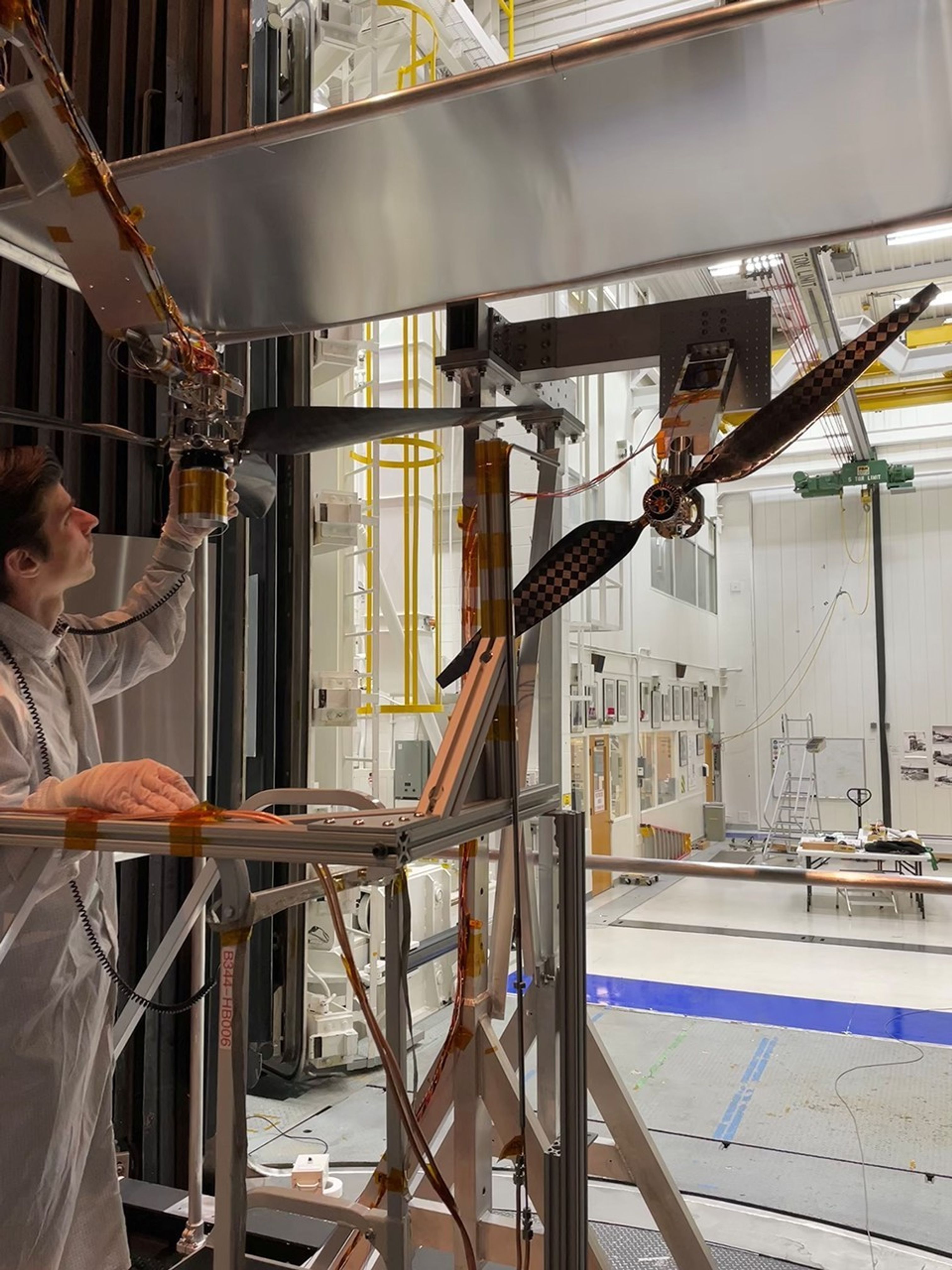
NASA/JPL-Caltech
Description
Engineer Jaakko Karras inspects a next-generation Mars helicopter rotor blade prior to supersonic speed testing in the 25-Foot Space Simulator at NASA’s Jet Propulsion Laboratory in Southern California in November 2025. The three-bladed rotor hanging horizontally in the foreground is the next-gen rotor being tested. The vertically aligned two-bladed rotor provided a “headwind,” enabling the tips of the three-bladed rotor to go beyond Mach 1. Data from the tests indicate that the next-gen rotor could surpass the sound barrier without breaking apart.
The agency’s Mars Exploration Program funded the test campaign in pursuit of maximizing the capability of future aircraft flying at the Red Planet. A division of Caltech in Pasadena, JPL manages the Mars Exploration Program for NASA’s Science Mission Directorate in Washington.
TechCrunch - Latest
Why you can never get your doctor to call you back
2026-05-08 04:42
Ramp in talks to hit $40B+ valuation, 6 months after reaching $32B
2026-05-07 23:11
OpenAI launches new voice intelligence features in its API
2026-05-07 22:24
Kodiak AI raises $100M at a steep discount, sending its stock tumbling 37%
2026-05-07 21:49
Disney looking to make a unified ‘super app,’ report says
2026-05-07 21:40


